In geodesy, conversion among different geographic coordinate systems is made necessary by the different geographic coordinate systems in use across the...
34 KB (5,207 words) - 08:18, 10 August 2024

geodetic altitude. Conversions between ECEF and geodetic coordinates (latitude and longitude) are discussed at geographic coordinate conversion. As with any...
9 KB (912 words) - 16:39, 14 December 2024

Geodetic datum (redirect from Geodetic Coordinate System)
(coordinates) Engineering datum Figure of the Earth Geoid Geographic coordinate conversion Grid reference International Terrestrial Reference System Kilometre...
32 KB (3,377 words) - 03:19, 15 May 2025
ight)}^{2}+{\left(y'z''-y''z'\right)}^{2}}}\end{aligned}}} Geographic coordinate conversion Transformation matrix Arfken, George (2013). Mathematical Methods...
11 KB (2,162 words) - 13:23, 13 February 2025

Latitude (redirect from Geographic latitude)
In geography, latitude is a geographic coordinate that specifies the north-south position of a point on the surface of the Earth or another celestial body...
47 KB (6,166 words) - 00:02, 19 March 2025
The Swiss coordinate system (or Swiss grid) is a geographic coordinate system used in Switzerland and Liechtenstein for maps and surveying by the Swiss...
7 KB (968 words) - 02:16, 21 January 2025

In mathematics, a spherical coordinate system specifies a given point in three-dimensional space by using a distance and two angles as its three coordinates...
43 KB (6,355 words) - 20:55, 14 April 2025

perpendicular, or "normal", radii of curvature of Earth (See also "Geographic coordinate conversion" for their formulas). It is derived by the approximation of...
27 KB (4,054 words) - 15:09, 19 April 2025
]. 新华网 (in Chinese). "Coordinate conversion" (in Chinese). Baidu Maps. Retrieved 7 April 2015. "坐标转换API" [Coordinate Conversion API]. developer.baidu...
29 KB (2,999 words) - 16:40, 10 May 2025

the UTM coordinate system, which means current UTM northing at a given point can differ up to 200 meters from the old. For different geographic regions...
18 KB (2,852 words) - 18:12, 30 March 2025

Specification 2), and in most geographic information system software. The map projection and the geographic coordinate system (GCS, latitude and longitude)...
21 KB (2,805 words) - 11:47, 25 December 2024
Geodetic coordinates (redirect from Geodetic coordinate system)
Geodetic coordinates are a type of curvilinear orthogonal coordinate system used in geodesy based on a reference ellipsoid. They include geodetic latitude...
7 KB (891 words) - 16:33, 18 March 2025

In mathematics, the polar coordinate system specifies a given point in a plane by using a distance and an angle as its two coordinates. These are the point's...
49 KB (6,702 words) - 21:47, 13 May 2025
estimate and should contain a statistical measure of its quality. Geographic coordinate conversion Procrustes analysis Surveying "Equations Used for Datum Transformations"...
14 KB (1,329 words) - 14:24, 27 July 2024

polar stereographic (UPS) coordinate system is used in conjunction with the universal transverse Mercator (UTM) coordinate system to locate positions...
4 KB (499 words) - 18:09, 11 June 2024
Radar geo-warping (category Geographic data and information)
does its scan conversion computations on the graphics processing unit to achieve high performance and visual quality. The bi-linear coordinate interpolation...
13 KB (1,974 words) - 02:14, 23 November 2024

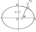
In geometry, the elliptic coordinate system is a two-dimensional orthogonal coordinate system in which the coordinate lines are confocal ellipses and...
9 KB (1,599 words) - 16:25, 17 November 2023
notably used in MapGuide. Simple Features Geography Markup Language Well-known text representation of coordinate reference systems Herring, John R., ed....
11 KB (804 words) - 21:26, 12 February 2025

Vector graphics (redirect from Conversion of vector graphics file formats)
purpose. Vector graphics are based on the mathematics of analytic or coordinate geometry, and is not related to other mathematical uses of the term vector...
28 KB (3,095 words) - 22:12, 28 April 2025

GIScience is often considered a subdiscipline of geography within the branch of technical geography. Geographic information systems are utilized in multiple...
102 KB (13,199 words) - 20:26, 22 May 2025

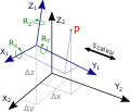
coordinates, projected on the celestial sphere, are analogous to the geographic coordinate system used on the surface of Earth. These differ in their choice...
29 KB (3,971 words) - 18:25, 17 April 2025
EPSG Geodetic Parameter Dataset (category Geographic coordinate systems)
projections Cain, Jim (9 May 2013). "Coordinate Reference Systems (Best Practices for Assignment, Manipulation and Conversion in GIS Systems)" (PDF). 2013 ESRI...
5 KB (444 words) - 20:42, 28 January 2025
or 850 and 4-10ths of an acre". Conversion of units Medieval weights and measures for details of the geographical league of France Mile for the various...
8 KB (949 words) - 04:20, 31 March 2024
English language (redirect from Geographic distribution of english)
variety of processes. One of the most productive processes in English is conversion, using a word with a different grammatical role, for example using a noun...
230 KB (23,432 words) - 01:25, 22 May 2025
support the use of a geographic information system, providing the ability to create, store, manage, query, analyze, and visualize geographic data, that is,...
26 KB (2,782 words) - 17:47, 8 April 2025
Ordnance Survey National Grid (category Geographic coordinate systems)
Irish Transverse Mercator (ITM) coordinate reference system was adopted in 2001 and is now the preferred coordinate reference system across Ireland....
19 KB (2,175 words) - 10:16, 2 May 2025
Web Mercator projection (category Geographic coordinate systems)
misuse.: 87 Mistaking Web Mercator for the standard Mercator during coordinate conversion can lead to deviations as much as 40 km on the ground. For all these...
16 KB (1,712 words) - 00:20, 1 September 2024

primitives include: Feature Geometry Coordinate reference system Topology Time Dynamic feature Coverage (including geographic images) Unit of measure Directions...
32 KB (4,027 words) - 14:55, 12 April 2024
Horizontal position representation (category Geographic coordinate systems)
be the case for ships and ground vehicles/cars. It is a type of geographic coordinate system. There are several options for horizontal position representations...
8 KB (756 words) - 05:26, 11 August 2024
Geocode (redirect from Geographic identifier)
represents a geographic entity (location or object). It is a unique identifier of the entity, to distinguish it from others in a finite set of geographic entities...
36 KB (3,233 words) - 21:55, 19 May 2025