
A hazard map is a map that highlights areas that are affected by or are vulnerable to a particular hazard. They are typically created for natural hazards...
5 KB (310 words) - 21:03, 6 October 2024

A seismic hazard is the probability that an earthquake will occur in a given geographic area, within a given window of time, and with ground motion intensity...
10 KB (1,160 words) - 23:47, 4 May 2025

A hazard is a potential source of harm. Substances, events, or circumstances can constitute hazards when their nature would potentially allow them to...
41 KB (5,248 words) - 15:59, 29 May 2025

USGS and revised in 1992 for the Island of Hawaiʻi, the maps outline the qualitative hazard posed by lava flows based on the history of lava flow activity...
6 KB (800 words) - 03:21, 12 May 2025
the area around the volcano, officials began planning for evacuation. A hazard map was prepared in October; it highlighted the danger from falling ash and...
25 KB (2,899 words) - 03:39, 26 April 2025
outlets about the danger in the weeks and days leading up to the eruption. Hazard maps for the vicinity were prepared but poorly distributed. On the day of...
58 KB (6,519 words) - 18:25, 28 April 2025
erosion hazard, as shown on a flood hazard boundary map or flood insurance rate map. Areas within the SFHA are designated on the flood insurance rate map as...
2 KB (172 words) - 01:30, 30 June 2023
Volcanological Survey of Indonesia (redirect from Vulcanology and Geological Hazard Mitigation Center)
gunungapi (Geologic map of volcano) Peta daerah bahaya gunungapi (Volcanic hazard map) Peta kawasan rawan bencana gunungapi (Volcanic hazard map of volcano) Its...
6 KB (412 words) - 05:04, 19 April 2025

Acceleration Hazard Maps for various periods Revision of Time-Independent Probabilistic Seismic Hazard Maps for Alaska What is a ground shaking hazard map? – Includes...
3 KB (232 words) - 12:56, 25 March 2025
single-writer/multi-reader shared pointer called "hazard pointer." When a reader thread assigns the address of a map to its hazard pointer, it is basically announcing...
6 KB (731 words) - 18:15, 31 October 2024

type of volcano. Eruption fears continued into the 2020s. In 2021, a new hazard map was created to help residents plan for evacuation, stoking fears because...
70 KB (6,224 words) - 17:40, 4 June 2025
made of nitrile rubber are worn when handling fluoride compounds. The hazards of solutions of fluoride salts depend on the concentration. In the presence...
46 KB (4,944 words) - 04:04, 2 June 2025

seismic hazard map showing Bulgaria, as well as the Vrancea Mountains fault in central Romania Bulgarian Academy of Sciences seismic hazard map showing...
8 KB (283 words) - 01:37, 21 February 2025
In digital logic, a hazard is an undesirable effect caused by either a deficiency in the system or external influences in both synchronous[citation needed]...
7 KB (997 words) - 15:41, 23 January 2025

Misti (section Monitoring and hazard management)
awareness campaigns on the dangers of renewed eruptions and published a hazard map. The Inca viewed the volcano as a threat and during the 1440–1470 eruption...
118 KB (14,188 words) - 16:04, 2 June 2025
(including seismic building codes) and it is commonly plotted on seismic hazard maps. In an earthquake, damage to buildings and infrastructure is related...
27 KB (2,265 words) - 04:30, 22 April 2025

Earthquake zones of India (redirect from Earthquake hazard zoning of india)
zoning map, Zone 5 expects the highest level of seismicity whereas Zone 2 is associated with the lowest level of seismicity. Revised earthquake hazard zone...
9 KB (1,020 words) - 13:02, 1 March 2025
Guide to Chemical Hazards. "#0038". National Institute for Occupational Safety and Health (NIOSH). NIOSH Pocket Guide to Chemical Hazards. "#0039". National...
141 KB (15,207 words) - 06:06, 2 June 2025
Government of Canada, Natural Resources Canada. "Simplified seismic hazard map for Canada, the provinces and territories". seismescanada.rncan.gc.ca...
32 KB (3,351 words) - 14:22, 5 June 2025

known as the "921 earthquake" killed more than 2,400 people. The seismic hazard map for Taiwan by the USGS shows 9/10 of the island at the most hazardous...
329 KB (31,712 words) - 01:10, 2 June 2025
insurance rate map (FIRM) is an official map of a community within the United States that displays the floodplains, more explicitly special hazard areas and...
4 KB (514 words) - 22:19, 2 October 2024

Ravi; Bhatia, S. C. (1999). "A new seismic hazard map for the Indian plate region under the global seismic hazard assessment programme". Current Science....
14 KB (1,566 words) - 16:36, 4 June 2025

earthquake. On March 28, 2016 the USGS released the USGS National Seismic Hazard Map which concluded that the primary cause of the earthquake in Oklahoma in...
64 KB (6,282 words) - 01:01, 2 May 2025

Map layout, also called map composition or (cartographic) page layout, is the part of cartographic design that involves assembling various map elements...
20 KB (2,380 words) - 14:07, 23 May 2025

Haleakalā (section Volcanic hazard)
lava-flow hazards are rated on a scale of one through nine with one being the zone of highest hazard and nine being the zone of lowest hazard. For example...
30 KB (2,692 words) - 05:37, 3 June 2025
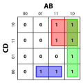
2-variable, 2 × 2 Karnaugh maps. Listed with each is the minterms as a function of ∑ m ( ) {\textstyle \sum m()} and the race hazard free (see previous section)...
30 KB (3,588 words) - 17:11, 17 March 2025

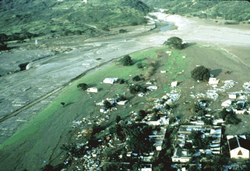
danger the volcano presented; locals even called it the "Sleeping Lion". Hazard maps showing Armero would be completely flooded after an eruption were distributed...
52 KB (5,871 words) - 14:17, 25 May 2025

slopes of the mountain. With USGS geologist Dick Janda, Voight drew a hazard map that included several populated areas within the danger zone. Before Voight...
30 KB (3,330 words) - 03:52, 24 September 2024

Seattle Fault (section Hazard)
Highway 90. The Seattle Fault was first recognized as a significant seismic hazard in 1992, when a set of reports showed that about 1,100 years ago it was...
35 KB (3,384 words) - 17:28, 23 May 2025

geologic hazard or geohazard is an adverse geologic condition capable of causing widespread damage or loss of property and life. These hazards are geological...
11 KB (1,147 words) - 14:02, 25 May 2025