
Newfoundland in the province of Newfoundland and Labrador. It connects the communities of Monkstown and Davis Cove with Route 210 (Heritage Run/Burin Peninsula...
2 KB (134 words) - 15:10, 22 October 2022
This is a list of highways in Newfoundland and Labrador. Newfoundland and Labrador is unusual among jurisdictions in Canada in that it exclusively uses...
39 KB (2,795 words) - 03:06, 2 March 2024

The Trans-Labrador Highway (TLH) is the primary public road in Labrador, the mainland portion of the province of Newfoundland and Labrador, Canada. The...
25 KB (1,536 words) - 11:01, 17 February 2025

of Newfoundland and Labrador. Its eastern terminus is the intersection at the Trans-Canada Highway (Route 1) in the Town of Badger, and the route ends...
4 KB (312 words) - 01:44, 16 July 2024

Route 30 is a 12.0-kilometre-long (7.5 mi) north-south provincial highway in Newfoundland and Labrador, extending from St. John's through Logy Bay-Middle...
3 KB (180 words) - 23:28, 14 February 2024

Route 201 (known as the Osprey Trail) is a provincial road in the Canadian province of Newfoundland and Labrador. It is one of only three loop roads designated...
4 KB (288 words) - 01:44, 16 July 2024

from Goobies to Grand Bank, Newfoundland and Labrador. The maximum speed limit is 90 km/h except through communities and settlements where the speed limit...
15 KB (719 words) - 15:08, 22 October 2022

Route 342 in Newfoundland and Labrador leads from Route 341 in Lewisporte to Embree and then to Little Burnt Bay, all on the island of Newfoundland. The...
3 KB (141 words) - 01:45, 16 July 2024
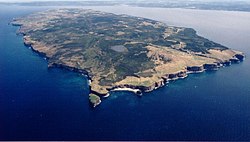
Bell Island is an island that is part of Newfoundland and Labrador, Canada's easternmost province. With an area of 34 square kilometres (13 sq mi), it...
127 KB (15,376 words) - 23:43, 5 June 2025

Route 20 is a 30.2-kilometre-long (18.8 mi) provincial highway in Newfoundland and Labrador, extending from St. John's to the towns of Torbay, Flatrock...
6 KB (302 words) - 21:23, 31 January 2025

Avalon Peninsula of Newfoundland in the Canadian province of Newfoundland and Labrador. Its southern terminus is at Route 10 in Goulds and its northern terminus...
4 KB (295 words) - 01:44, 16 July 2024

in the Canadian province of Newfoundland and Labrador. It connects the town of Burgeo with the Trans-Canada Highway (Route 1). The highway is a winding...
4 KB (286 words) - 16:35, 18 April 2023

example of a road concurrency in the entire province of Newfoundland and Labrador. Route 461/Route 490 now cross a bridge over an inlet to enter Stephenville...
4 KB (234 words) - 15:38, 15 July 2024

province of Newfoundland and Labrador. The road provides a direct link from the Trans-Canada Highway (TCH) to downtown St. John's, Newfoundland, which was...
10 KB (653 words) - 22:11, 30 August 2024
turn and coming to an end shortly thereafter at another intersection with Route 235 (Church Street). As with most highways in Newfoundland and Labrador, the...
12 KB (593 words) - 01:43, 16 July 2024

Newfoundland in the Canadian province of Newfoundland and Labrador. It begins at a junction of Route 430 in Wiltondale and terminates at Trout River. It serves...
4 KB (244 words) - 18:21, 5 April 2024

highway on the Avalon Peninsula of Newfoundland. It runs between the town of Cupids and the city of St. John's. Route 60 begins as Topsail Road at the west...
8 KB (342 words) - 06:57, 16 January 2023
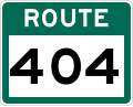
Route 404 is a short provincial highway on the west coast of Newfoundland in the Canadian province of Newfoundland and Labrador. It is one of four provincial...
4 KB (213 words) - 01:44, 16 July 2024

Canadian province of Newfoundland and Labrador. The route begins at the intersection of Route 1 (The Trans Canada Highway) in Deer Lake and ends in St. Anthony...
14 KB (825 words) - 18:21, 5 April 2024

Route 403 is a minor highway in the western region of Newfoundland in the Canadian province of Newfoundland and Labrador. The highway begins at a junction...
2 KB (134 words) - 01:45, 16 July 2024

Cove-St. Philips in Newfoundland and Labrador, Canada. Route 40 also serves as the primary access to St. John's International Airport and the Bell Island...
4 KB (271 words) - 21:09, 30 August 2024

Route 440 (also known as Admiral Palliser's Trail) is a relatively short highway in the Canadian province of Newfoundland and Labrador, on the West Coast...
4 KB (342 words) - 01:44, 16 July 2024

intersection between Route 320 (Road to the Shore) and a local road to Wesleyville. List of Newfoundland and Labrador highways "Route 330" (Map). Google...
7 KB (355 words) - 21:46, 21 May 2024
Route 1 is a highway in the Canada province of Newfoundland and Labrador, and is the easternmost stretch of the Trans-Canada Highway. Route 1 is the primary...
32 KB (1,175 words) - 00:58, 24 December 2024

province of Newfoundland and Labrador. It straddles the line between the provinces two largest cities, the capital city of St. John's and the city Mount...
7 KB (610 words) - 21:57, 8 March 2025

the Avalon Peninsula of Newfoundland. The highway also carries the designation of Baccalieu Trail for its entire length. Route 70 begins in Roaches Line...
9 KB (348 words) - 01:43, 16 July 2024

Newfoundland in the province of Newfoundland and Labrador. It connects the towns of Boat Harbour, Brookside, and Petit Forte with Route 210 (Heritage Run/Burin...
4 KB (246 words) - 15:11, 22 October 2022

the Canadian province of Newfoundland and Labrador. The highway begins at a junction with Route 1 (Trans-Canada Highway) and continues to its west terminus...
3 KB (186 words) - 15:42, 22 October 2022

Route 470, also known as La Poile Highway, is a highway on the West Coast of the Canadian province of Newfoundland and Labrador. It is the last provincial...
5 KB (368 words) - 01:44, 16 July 2024
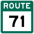
Route 71 (also known as Hodgewater Line) is a highway in the Canadian province of Newfoundland and Labrador. It serves as a bypass road to Route 70 and...
3 KB (118 words) - 01:45, 16 July 2024