
Route 330 Beaton Tulk Highway, also known as Road to the Shore or more commonly Gander Bay Road, is a highway that extends from Gander, Newfoundland across...
7 KB (355 words) - 21:46, 21 May 2024
This is a list of highways in Newfoundland and Labrador. Newfoundland and Labrador is unusual among jurisdictions in Canada in that it exclusively uses...
39 KB (2,795 words) - 03:06, 2 March 2024

The Trans-Labrador Highway (TLH) is the primary public road in Labrador, the mainland portion of the province of Newfoundland and Labrador, Canada. The...
25 KB (1,536 words) - 11:01, 17 February 2025

in the Canadian province of Newfoundland and Labrador. It connects the town of Burgeo with the Trans-Canada Highway (Route 1). The highway is a winding...
4 KB (286 words) - 16:35, 18 April 2023

of Newfoundland and Labrador. Its eastern terminus is the intersection at the Trans-Canada Highway (Route 1) in the Town of Badger, and the route ends...
4 KB (312 words) - 01:44, 16 July 2024
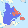
The border between the province of Newfoundland and Labrador and the province of Quebec is the longest interprovincial border in Canada. It stretches...
59 KB (6,527 words) - 15:45, 23 May 2025

Newfoundland in the Canadian province of Newfoundland and Labrador. It serves as a loop route off of Route 330 (Gander Bay Road), connecting several communities...
3 KB (180 words) - 15:21, 22 October 2022
Route 1 is a highway in the Canada province of Newfoundland and Labrador, and is the easternmost stretch of the Trans-Canada Highway. Route 1 is the primary...
32 KB (1,175 words) - 00:58, 24 December 2024
in the northeastern part of the island of Newfoundland in the Canadian province of Newfoundland and Labrador, approximately 40 km (25 mi) south of Gander...
36 KB (2,690 words) - 20:28, 9 May 2025
Labrador City is a town in western Labrador (part of the Canadian province of Newfoundland and Labrador), near the Quebec border. With a population of...
22 KB (1,077 words) - 23:33, 29 April 2025
Route 450A, also known as Lewin Parkway, is an alternate route of Route 450 in the city of Corner Brook, Newfoundland and Labrador. The route runs from...
3 KB (172 words) - 23:55, 10 May 2023

Route 20 is a 30.2-kilometre-long (18.8 mi) provincial highway in Newfoundland and Labrador, extending from St. John's to the towns of Torbay, Flatrock...
6 KB (302 words) - 21:23, 31 January 2025

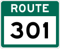
Avalon Peninsula of Newfoundland in the Canadian province of Newfoundland and Labrador. Its southern terminus is at Route 10 in Goulds and its northern terminus...
4 KB (295 words) - 01:44, 16 July 2024

two being where Route 320 transitions to Route 330 (Road to the Shore/Gander Bay Road). List of Newfoundland and Labrador highways "Route 320" (Map). Google...
4 KB (210 words) - 15:29, 15 July 2024

Route 360, also known as Bay d'Espoir Highway, is a provincial highway in Newfoundland and Labrador. It runs from the Bishop's Falls area to Bay d'Espoir...
7 KB (426 words) - 01:44, 16 July 2024

Route 239 is a highway in the Trinity Bight portion of Newfoundland in the Canadian province of Newfoundland and Labrador. It is a short route, running...
3 KB (216 words) - 15:16, 22 October 2022

Route 201 (known as the Osprey Trail) is a provincial road in the Canadian province of Newfoundland and Labrador. It is one of only three loop roads designated...
4 KB (288 words) - 01:44, 16 July 2024

Route 403 is a minor highway in the western region of Newfoundland in the Canadian province of Newfoundland and Labrador. The highway begins at a junction...
2 KB (134 words) - 01:45, 16 July 2024

province of Newfoundland and Labrador. The road provides a direct link from the Trans-Canada Highway (TCH) to downtown St. John's, Newfoundland, which was...
10 KB (653 words) - 22:11, 30 August 2024

Canadian province of Newfoundland and Labrador. The route begins at the intersection of Route 1 (The Trans Canada Highway) in Deer Lake and ends in St. Anthony...
14 KB (825 words) - 18:21, 5 April 2024

Route 213 is a highway on the Burin Peninsula of the island of Newfoundland in the Canadian province of Newfoundland and Labrador. It is one of a small...
3 KB (189 words) - 15:10, 22 October 2022

Newfoundland in the province of Newfoundland and Labrador. It connects the town of Boyd's Cove with the Gander Bay area of the island. Route 331 begins in Boyd's...
4 KB (196 words) - 15:21, 22 October 2022

Newfoundland and Labrador. Its southern terminus is at Route 90 in St. Vincent's-St. Stephen's-Peter's River, and its northern terminus is at Route 2...
7 KB (338 words) - 23:27, 14 February 2024

highway on the Avalon Peninsula of Newfoundland. It runs between the town of Cupids and the city of St. John's. Route 60 begins as Topsail Road at the west...
8 KB (342 words) - 06:57, 16 January 2023

Newfoundland in the Canadian province of Newfoundland and Labrador. It begins at a junction of Route 430 in Wiltondale and terminates at Trout River. It serves...
4 KB (244 words) - 18:21, 5 April 2024

island of Newfoundland in the Canadian province of Newfoundland and Labrador. It is a relatively short highway with no other towns on the route other than...
2 KB (100 words) - 01:44, 16 July 2024

Route 100 (also known as The Cape Shore Highway and Argentia Access Road) is a major highway in Newfoundland and Labrador. The highway begins at its northern...
8 KB (472 words) - 23:31, 14 February 2024
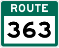
of Newfoundland. It is located entirely with the town of St. Jacques-Coomb's Cove, connecting the communities on the western half of town with Route 362...
3 KB (166 words) - 14:20, 27 April 2024
in the province of Newfoundland and Labrador. It serves as the only road connection to the town of Terra Nova, connecting with Route 1 (Trans-Canada Highway)...
3 KB (173 words) - 13:17, 5 March 2025

Connaigre Peninsula of the island of Newfoundland. It connects the communities along the western side of Fortune Bay with Route 360 (Bay d'Espoir Highway). Cell...
5 KB (267 words) - 14:20, 27 April 2024