
Oregon Route 223 is a state highway in the U.S. State of Oregon, which runs between the town of Wren, Oregon and the city of Dallas, Oregon. It is known...
4 KB (245 words) - 21:20, 21 January 2024

intersections with Oregon Route 223 and Oregon Route 99W, along with a spur route of OR 223 further to the west. East of the OR 223 interchange, OR 22...
14 KB (918 words) - 02:56, 26 April 2024

(5 km) south of Monmouth to Oregon Route 223 near Lewisville following today's Elkins Rd. In those days, Oregon Route 223 followed today's Airlie Rd and...
7 KB (686 words) - 09:25, 23 June 2023
numbered 223: Nova Scotia Route 223 Prince Edward Island Route 223 Quebec Route 223 China National Highway 223 National Route 223 Japan National Route 223 U...
2 KB (161 words) - 23:27, 4 April 2024

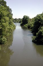
census-designated place in Benton County, Oregon, United States. It is located on the Luckiamute River and Oregon Route 223, the Kings Valley Highway. As of the...
3 KB (247 words) - 02:21, 28 May 2024

unincorporated community in Polk County, Oregon, United States. Pedee is at the intersection of Oregon Route 223 and Maple Grove Road. It is part of the...
959 bytes (72 words) - 00:10, 18 November 2023

Oregon Route 99 is a state highway that runs between the southern border of Oregon, and the city of Junction City. Oregon Route 99 was formed from parts...
16 KB (532 words) - 07:42, 23 June 2023
crosses under Route 20 again, turns east, receives Gellatly Creek and La Bare Creek, both from the left, and passes under Oregon Route 223 at about 22 miles...
11 KB (1,071 words) - 14:17, 27 May 2024

U.S. Route 30 (US 30) in the U.S. state of Oregon is a major east–west United States Numbered Highway that runs from its western terminus in Astoria to...
36 KB (2,200 words) - 22:34, 25 May 2024

Oregon Route 194 is an Oregon state highway running from OR 223 near Dallas to OR 99W and OR 51 in Monmouth. OR 194 is known as the Monmouth Highway No...
2 KB (238 words) - 07:43, 23 June 2023
state of Oregon, there are two systems for categorizing roads in the state highway system: named state highways and numbered state routes. Named highways...
93 KB (600 words) - 15:53, 11 May 2024

Oregon Route 99W is a state-numbered route in Oregon, United States, that runs from OR 99 and OR 99E in Junction City north to I-5 in southwestern Portland...
14 KB (1,249 words) - 22:58, 16 May 2024

licensed to the city. Dallas' only hospital is West Valley Hospital. Oregon Route 223 is the only state highway that serves the city. Jeri Ellsworth, self-taught...
20 KB (1,845 words) - 17:13, 16 May 2024

U.S. Route 20 (US 20) is a major west–east cross-state highway in the northern part of the U.S. state of Oregon, especially east of the Cascade Mountains...
19 KB (943 words) - 01:56, 16 October 2023

U.S. Route 26 (US 26) is a major cross-state United States Numbered Highway with its western terminus in the U.S. state of Oregon, connecting US 101 on...
25 KB (1,490 words) - 15:33, 21 March 2024

community in Polk County, Oregon, United States. Bridgeport is 5 miles (8.0 km) southwest of Dallas and just west of Oregon Route 223. "Bridgeport". Geographic...
852 bytes (64 words) - 23:39, 17 November 2023

The route from here to the Maumee River is also known as Woodville Road. The route interchanges with Interstate 280 before entering southwest Oregon and...
7 KB (383 words) - 02:31, 19 May 2024

unincorporated community in Benton County, Oregon, United States. It is located at the junction of U.S. Route 20 and Oregon Route 223 on the Marys River. Wren was named...
2 KB (190 words) - 00:57, 21 May 2024
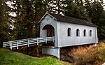
Ritner Creek Bridge (category National Register of Historic Places in Polk County, Oregon)
Bridge was the last covered bridge on a state highway in Oregon. It carried Oregon Route 223 (OR 223) over Ritner Creek between Pedee and Kings Valley, about...
3 KB (302 words) - 00:10, 31 December 2023

U.S. Route 97 (US 97) in the U.S. state of Oregon is a major north–south United States highway which runs from the California border, south of Klamath...
27 KB (2,121 words) - 15:47, 1 June 2024

state of Oregon, there are two systems for categorizing roads in the state highway system: named state highways and numbered state routes. Named highways...
42 KB (235 words) - 04:49, 2 January 2024

Lanark, Mount Morris, Oregon, Sycamore, Lily Lake, Saint Charles and the western suburbs of Chicago before terminating at U.S. Route 41 (US 41, Lake Shore...
15 KB (818 words) - 03:45, 25 January 2024

Oregon Route 222 (OR 222) is an Oregon state highway, consisting of two disconnected sections in Lane County. The north section runs from OR 126 Business...
4 KB (418 words) - 17:18, 25 May 2024

Little Luckiamute River (category Rivers of Polk County, Oregon)
the right, then passes under Oregon Route 223 at about RM 8 (RK 13). Fern Creek enters from the left just beyond Route 223, and Cooper Creek enters from...
7 KB (539 words) - 09:37, 10 May 2020

to Oregon pioneers and as a comfort station for travelers on the Historic Columbia River Highway. The site, on a rocky promontory, is 733 feet (223 m)...
7 KB (621 words) - 15:39, 27 February 2024

Ritner Creek (category Rivers of Polk County, Oregon)
Sheythe, Love, Clayton, and Kinsey creeks. Ritner Creek passes under Oregon Route 223 just before entering the river. The Ritner Creek Bridge, a 75-foot...
5 KB (374 words) - 02:34, 11 May 2020

Mount Hood (redirect from Mount Hood (Oregon))
snowfields. It is the highest point in Oregon and the fourth highest in the Cascade Range. Mount Hood is considered the Oregon volcano most likely to erupt, though...
55 KB (4,695 words) - 16:47, 8 May 2024

Interstate 82 (redirect from Interstate 82 (Oregon))
with U.S. Route 97 (US 97) between Ellensburg and Union Gap; US 12 from Yakima to the Tri-Cities; and US 395 from Kennewick to Umatilla, Oregon. I-82 primarily...
96 KB (8,852 words) - 23:38, 3 May 2024

Arlington is a city in Gilliam County, Oregon, United States. The city's population was 586 at the 2010 census and has a 2019 estimate of 591. The account...
29 KB (2,058 words) - 00:05, 29 May 2024

the Northern Oregon Coast Range along the South Yamhill River. Sheridan lies west of the county seat of McMinnville, along Oregon Route 18. This highway...
42 KB (3,985 words) - 20:04, 21 May 2024