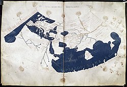
The Ptolemy world map is a map of the world known to Greco-Roman societies in the 2nd century. It is based on the description contained in Ptolemy's book...
7 KB (724 words) - 17:11, 27 January 2025

Ptolemy's map of Ireland is a part of his "first European map" (depicting the British Isles) in the series of maps included in his Geography, which he...
22 KB (1,920 words) - 21:19, 24 May 2025
the Roman era, with Ptolemy's world map (2nd century CE), which would remain authoritative throughout the Middle Ages. Since Ptolemy, knowledge of the approximate...
73 KB (8,596 words) - 22:27, 18 May 2025

from an earlier map, although this could not have been an exact copy of Ptolemy's work: his Prime Meridian was 10° east of Ptolemy's, he adds some places...
68 KB (6,475 words) - 07:08, 27 May 2025

Cartography of the United States (redirect from Map of florida)
States is the history of surveying and creation of maps of the United States. Maps of the New World had been produced since the 16th century. The history...
2 KB (201 words) - 09:40, 30 May 2025
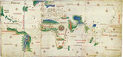
exist) Map of Maximus Planudes (c. 1300), earliest extant realization of Ptolemy's world map (2nd century) Gangnido (Korea, 1402) Bianco world map (1436)...
4 KB (372 words) - 23:00, 5 December 2022
Cartography of Europe (redirect from Map of italy)
Mediterranean, an arrangement that was adhered to in medieval T and O maps. Ptolemy's world map of the 2nd century already had a reasonably precise description...
2 KB (229 words) - 00:47, 28 May 2025

Cartography of Africa (redirect from Map of africa)
Catabathmus Magnus (the escarpment of Akabah el-Kebir in western Egypt). Ptolemy's world map (2nd century) shows a reasonable awareness of the general topography...
4 KB (419 words) - 05:26, 5 August 2024

Printed Maps. British Museum Press. Taub, Liba Chia (1993). Ptolemy's Universe: The natural philosophical and ethical foundations of Ptolemy's astronomy...
77 KB (8,229 words) - 10:06, 3 June 2025
Cape Route (redirect from Indo-Atlantic world)
Ptolemy's world map, on which the geographic knowledge of medieval Europe was founded, displays the oceans as separated from each other, with Ptolemy...
7 KB (800 words) - 13:21, 20 May 2025

Chittagong (section World War II)
the world's oldest ports with a functional natural harbor for centuries, Chittagong appeared on ancient Greek and Roman maps, including on Ptolemy's world...
116 KB (10,522 words) - 19:34, 2 June 2025

Cartography (redirect from Map making)
wrote his treatise on cartography, Geographia. This contained Ptolemy's world map – the world then known to Western society (Ecumene). As early as the 8th...
65 KB (7,642 words) - 16:26, 14 May 2025
Cantino planisphere (redirect from Cantino World Map)
The Cantino planisphere or Cantino world map is a manuscript Portuguese world map preserved at the Biblioteca Estense in Modena, Italy. It is named after...
18 KB (2,381 words) - 10:38, 5 June 2025

The map of Juan de la Cosa is a world map that includes the earliest known representation of the New World and the first depiction of the equator and the...
10 KB (1,187 words) - 11:36, 24 May 2025
The "Old World" (Latin: Mundus vetus) is a term for Afro-Eurasia coined by Europeans after 1493, when they became aware of the existence of the Americas...
4 KB (324 words) - 16:47, 26 May 2025
Cartography of India (redirect from Map of india)
Al-Ma'mun improved on Ptolemy's work and depicted the Indian Ocean as an open body of water instead of a land-locked sea as Ptolemy had done. The Iranian...
19 KB (2,265 words) - 05:09, 20 May 2025

Chernobyl (section Identity of Ptolemy's "Azagarium")
Eastern Europe mention "Czernobol" (Chernobyl) with reference to Ptolemy's world map (2nd century AD). Czernobol is identified as Azagarium [uk] "oppidium...
47 KB (4,029 words) - 04:30, 13 May 2025

Nicolaus Germanus (section Ptolemy's Geographia)
was a German cartographer who modernized Ptolemy's Geography by applying new projections, adding additional maps, and contributing other innovations that...
9 KB (995 words) - 19:10, 6 May 2025

topological map is a type of diagram that has been simplified so that only vital information remains and unnecessary detail has been removed. These maps lack...
2 KB (135 words) - 06:47, 31 May 2025
History of Chittagong (section World War II)
the world's oldest ports with a functional natural harbor for centuries, Chittagong appeared on ancient Greek and Roman maps, including on Ptolemy's world...
35 KB (4,172 words) - 21:30, 11 March 2025

Vespucci. The map also first showed the Pacific Ocean, separating the Americas from Asia. The map is drafted on a modification of Ptolemy's second projection...
52 KB (7,139 words) - 19:54, 6 April 2025

the world's oldest ports with a functional natural harbor for centuries, Chittagong appeared on ancient Greek and Roman maps, including on Ptolemy's world...
8 KB (435 words) - 17:58, 28 February 2025

Catalan Atlas (category Historic maps of the world)
(Catalan: Atles català, Eastern Catalan: [ˈatləs kətəˈla]) is a medieval world map, or mappa mundi, probably created in the late 1370s or the early 1380s...
38 KB (3,439 words) - 13:54, 25 May 2025

utility and general significance of Ptolemy’s Theorem, it is especially useful to study its main Corollaries. Ptolemy's Theorem yields as a corollary a theorem...
28 KB (5,051 words) - 22:17, 19 April 2025

borrowing their attributes and being frequently conflated with them. Ptolemy's world map listed 12 winds: Septentrio (N), Aquilo (NNE), Vulturnus (NE), Subsolanus...
18 KB (2,037 words) - 21:44, 15 March 2025

Tetrabiblos (section Ptolemy's philosophical arguments)
transmitted to Ptolemy Greek astronomy – the astronomy of Ptolemy's era Ptolemy's world map – map of the ancient world as described by Ptolemy Quoted by Luck...
121 KB (14,884 words) - 17:12, 28 February 2025

first became a chain of freshwater lakes and marshes, as shown by Ptolemy's world map, then it became extinct about 2000 years ago.: 28 Abundant prehistoric...
3 KB (283 words) - 05:19, 16 July 2024

The Cassini Map or Academy's Map is the first topographic and geometric map made of the Kingdom of France as a whole. It was compiled by the Cassini family...
6 KB (779 words) - 06:30, 20 May 2025

with the world map. Lucio Russo has speculated about a probable arrival of Phoenicians in the Americas in his philologic analyses of Ptolemy's Geography...
15 KB (1,792 words) - 07:49, 23 April 2025
Cartography of France (redirect from Map of Cassini)
world; toponyms known as "Cassini signs" still exist, revealing where triangulated measurements at that time were made. The "map of Cassini" or "map of...
13 KB (1,566 words) - 00:53, 19 November 2023