
Spring Creek Pass, elevation 10,898 ft (3,322 m), is a mountain pass on the Continental Divide in the San Juan Mountains of Colorado. The pass is traversed...
3 KB (259 words) - 23:20, 29 March 2025

from this spot toward Spring Creek Pass. The road sign at the high point refers to Slumgullion Summit rather than Slumgullion Pass in order to reflect this...
7 KB (410 words) - 01:25, 28 October 2024

Rollins Pass are the following creeks: the South Fork of Ranch Creek, the Middle Fork of Ranch Creek (fed by Deadman's Lake), and Ranch Creek (fed by...
219 KB (19,302 words) - 00:25, 25 May 2025

Wolf Creek Pass is a high mountain pass on the Continental Divide, in the San Juan Mountains of Colorado. It is the route through which U.S. Highway 160...
20 KB (1,253 words) - 16:05, 31 January 2025

Smuts Pass, Alberta Soldier Summit, Utah South Pass, Wyoming Spring Creek Pass, Colorado Spring Valley Summit, Idaho Stone Man Pass, Colorado Stony Pass, Colorado...
44 KB (3,246 words) - 18:07, 16 April 2025

pass crosses the Continental Divide of the Americas. Cottonwood Pass is normally closed from about November 7 through about May 25. Independence Pass...
53 KB (720 words) - 05:02, 24 April 2025
Mountain passes on the Continental Divide of the Americas. Note Column:A=Automobile road R=Railway E=Used by early explorers *=not strictly a mountain pass on...
42 KB (273 words) - 19:36, 23 March 2024

Creek Pass, elevation 9,346 ft (2,849 m), is a mountain pass located in the Rocky Mountains of south-central Colorado in the United States. The pass sits...
4 KB (339 words) - 07:06, 10 May 2025

follows the Rio Grande River through Creede and rejoins the main CDT at Spring Creek Pass San Juan Mountains and Weminuche Wilderness. The CDT follows high...
41 KB (4,800 words) - 12:03, 27 February 2025
of the western United States. The pass is located west of Denver, and provides a high route between upper Clear Creek Canyon to the upper valley of the...
15 KB (1,121 words) - 02:07, 23 May 2025

the pass to Cebolla Creek and then upstream to what is now known as Spring Creek Pass on their way to the headwaters of the Rio Grande. By the mid-1870s...
6 KB (598 words) - 04:53, 24 August 2023

Grande Wolf Creek Pass is the route of U.S. Highway 160 between Del Norte, Colorado and Pagosa Springs, Colorado, while Spring Creek Pass is the route...
46 KB (5,403 words) - 19:48, 4 May 2025

Visitors must walk across the wide and shallow Medano Creek to reach the dunes in spring and summer. The creek typically has a peak flow from late May to early...
77 KB (8,177 words) - 17:44, 22 April 2025

Cold Creek is an unincorporated community in Clark County, Nevada, United States located within the Spring Mountains National Recreation Area and approximately...
8 KB (659 words) - 01:42, 21 May 2025

Juniper Creek that winds its way to Lake George in the Saint Johns River. It is one of the oldest and best known recreation areas. The springs, set in...
5 KB (456 words) - 03:57, 9 January 2025

the head of the Peru Creek, a tributary that joins the Snake River just north of Montezuma. The continental divide at Argentine Pass serves as the boundary...
14 KB (1,680 words) - 15:42, 21 May 2024

Southern Rocky Mountains (section Mountain passes)
Platte River; and the drainage running southwest from the pass down Pacific Creek and Sandy Creek to the Green River. This divide between the Southern Rockies...
58 KB (5,092 words) - 23:25, 1 January 2025

Thread Scenic and Historic Byway crosses the Continental Divide on Spring Creek Pass at 10,898 feet (3,322 m) elevation, but reaches its highest elevation...
47 KB (3,155 words) - 02:40, 18 February 2025
Beartooth Highway (redirect from Beartooth pass)
opened in 1936, it essentially followed Sheridan's route over the pass. During the spring of 2005, several large mudslides and rockslides on May 19–20 damaged...
12 KB (1,058 words) - 06:33, 24 February 2025

Deep Creek Hot Springs, DCHS, are natural hot springs located in the northern Mojave Desert section of the San Bernardino National Forest, near Hesperia...
7 KB (414 words) - 05:50, 15 February 2025

The Spring Creek Fire was a wildfire near Fort Garland and La Veta, Colorado in Costilla and Huerfano counties in southern Colorado. The fire burned a...
6 KB (490 words) - 02:34, 25 May 2025

Wolf Creek Ski Area (WCSA) is a ski area in southwest Colorado, located on the Wolf Creek Pass between Pagosa Springs and South Fork. It is best known...
19 KB (2,416 words) - 04:54, 17 April 2025

The spring is 100 miles (160 km) further than the spot Meriwether Lewis reported in 1805 as the source of the Missouri above Lemhi Pass on Trail Creek. Both...
3 KB (420 words) - 21:11, 14 February 2025
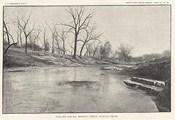
species of flora and fauna. The creek passes through Barton Creek Greenbelt and is fed by Barton Springs. The creek begins in northern Hays County and...
7 KB (595 words) - 14:52, 3 February 2025

South Boulder Creek is a tributary of Boulder Creek in central Colorado in the United States. Its source is near Rogers Pass on the Continental Divide...
2 KB (98 words) - 05:09, 4 February 2025

"خون"-"Khun" means house and "جراب"-"Jerab" means a creek coming from a spring or a waterfall. The Khunjerab Pass holds several distinctions, including being...
9 KB (935 words) - 03:41, 6 March 2025
of mountain passes Rocky Mountains Canadian Rockies Central Rocky Mountains Western Rocky Mountains Southern Rocky Mountains Mountain pass List of mountain...
104 KB (294 words) - 15:14, 5 April 2024
Johnson Springs (now known as Enoch) and the meadow by 15 miles (24 km), avoiding the longer route via Cedar Spring, Antelope Spring, Pyute Creek to Road...
30 KB (2,642 words) - 19:38, 11 March 2024

Altamont Pass even farther north. On the west side of the pass lies Casa de Fruta, an extensive trading post in the valley of Pacheco Creek. Originally...
11 KB (1,121 words) - 20:11, 13 October 2024
to the west, along Missouri Route J, which passes through the community. A post office called Spring Creek was established in 1868, and remained in operation...
2 KB (206 words) - 01:22, 18 May 2025