
Vertical exaggeration (VE) is a scale that is used in raised-relief maps, plans and technical drawings (cross section perspectives), in order to emphasize...
3 KB (304 words) - 17:54, 4 November 2024

using "vertical exaggeration" in order to make subtle elevation differences more noticeable. Some scientists, however, object to vertical exaggeration as...
31 KB (3,352 words) - 04:25, 21 February 2025
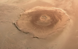
data, showing the volcano's asymmetry. The view is from the NNE; vertical exaggeration is 10×. The wider, gently sloping northern flank is to the right...
30 KB (3,606 words) - 05:14, 17 May 2025

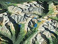
south. Oblique Landsat image draped over digital elevation data (x3 vertical exaggeration), Goat Paddock crater (circular feature in centre); screen capture...
3 KB (262 words) - 00:28, 7 May 2024

Earth's rate of curvature as shown in Zetetic Astronomy. Vertical exaggeration 1000×....
16 KB (1,932 words) - 09:50, 9 April 2025

Puerto Rico Trench formed at the plate boundary zone between the Caribbean and obliquely subducting North American plates. Vertical exaggeration is 5:1....
14 KB (1,419 words) - 21:00, 4 November 2024

Tabun-Khara-Obo crater draped over digital elevation model (x5 vertical exaggeration); screen capture from NASA World Wind. View to north across the...
4 KB (344 words) - 06:32, 11 March 2024
Day, or V-E Day Viva Emptiness, a music album by Katatonia Vertical exaggeration, a vertical scaling used in technical diagrams Vocational expert, an authority...
2 KB (338 words) - 21:14, 28 July 2024

Geoid (category Vertical datums)
The geoid in turn serves as a reference coordinate surface for various vertical coordinates, such as orthometric heights, geopotential heights, and dynamic...
29 KB (3,445 words) - 00:20, 12 May 2025
through southern England, showing the Weald Basin, which was inverted during the Alpine Orogeny forming the Wealden Anticline. Vertical exaggeration 1:5....
9 KB (1,127 words) - 06:02, 30 December 2024

Landsat image of Oasis crater draped over digital elevation model (x5 vertical exaggeration); screen capture from NASA World Wind "Oasis". Earth Impact Database...
4 KB (376 words) - 08:12, 21 April 2025
the base for architectural models, and is usually done without vertical exaggeration. For models of landforms, the stack can then be smoothed by filling...
13 KB (1,663 words) - 21:06, 4 April 2025
of meters due to regional deviations in the direction of the plumbline (vertical). These regional geodetic datums, such as ED 50 (European Datum 1950) or...
38 KB (4,261 words) - 06:28, 6 May 2025

Oblique Landsat image of Ouarkziz crater draped over digital elevation model (x2 vertical exaggeration); screen capture from NASA World Wind...
4 KB (363 words) - 17:27, 3 April 2025

Oblique Landsat image draped over digital elevation data (x3 vertical exaggeration), eroded remnant of Piccaninny crater (circular feature in centre);...
4 KB (277 words) - 23:19, 11 August 2024

Puerto Rico Trench formed at the plate boundary zone between the Caribbean and obliquely subducting North American Plates. Vertical exaggeration is 5:1....
3 KB (230 words) - 22:29, 18 November 2022
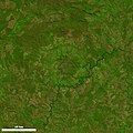
Oblique Landsat image of Araguainha crater draped over digital elevation model (5× vertical exaggeration); screen capture from NASA World Wind...
17 KB (1,393 words) - 04:08, 15 May 2025

and light green represent high elevations; dark green and blue are lower elevations. Image is approximately 175 km across. Vertical exaggeration is 3X....
2 KB (172 words) - 03:50, 13 February 2024

Oblique Landsat image draped over digital elevation model (x10 vertical exaggeration), Lawn Hill crater (circular depression in centre); screen capture...
5 KB (452 words) - 02:09, 24 January 2025

Oblique Landsat image draped over digital elevation model (x5 vertical exaggeration), Foelsche crater (beneath circular hill in centre); screen capture...
4 KB (393 words) - 00:28, 7 May 2024

Oblique Landsat image of Talemzane crater draped over digital elevation model (x3 vertical exaggeration); screen capture from NASA World Wind...
4 KB (386 words) - 22:04, 13 April 2025

image of Lake Acraman draped over digital elevation model (10x vertical exaggeration), looking east towards the Flinders Ranges where ejecta has been...
9 KB (848 words) - 03:50, 7 March 2025

Oblique Landsat image of Gweni-Fada crater draped over digital elevation model (x2 vertical exaggeration); screen capture from NASA World Wind...
6 KB (566 words) - 08:26, 21 April 2025

Maat Mons with a vertical exaggeration of 22.5. Maat Mons is the second-highest mountain on Venus, and is a recently active shield volcano....
22 KB (2,743 words) - 07:38, 14 February 2025

Oblique Landsat image draped over digital elevation data (×5 vertical exaggeration), Spider crater; screen capture from NASA WorldWind...
4 KB (365 words) - 00:30, 7 May 2024

medium depths at sea, light comes from above, so a mirror that is oriented vertically makes animals such as fish invisible from the side. In the shallower epipelagic...
74 KB (8,402 words) - 02:21, 27 September 2024
Anticline, note the unsymmetrical lower Cretaceous/Jurassic sediments in the core of the anticline. The diagram has undergone extensive vertical exaggeration...
12 KB (1,445 words) - 17:14, 1 April 2025
image of Holleford crater draped over digital elevation model (x10 vertical exaggeration). Although the crater itself is buried, its location (arrows) is...
7 KB (419 words) - 06:13, 18 August 2024
its slopes; they can be circular (craters) or linear (fissures). vertical exaggeration A scale used in certain maps, such as raised-relief maps, that deliberately...
212 KB (20,351 words) - 18:30, 6 May 2025

boundary is marked by a monocline, the Purbeck Monocline, resulting in a near-vertical chalk ridge which forms the Purbeck Hills of Dorset, running under the...
10 KB (1,240 words) - 16:58, 28 July 2023