In aviation, vertical navigation (VNAV, usually pronounced vee-nav) is glidepath information provided during an instrument approach, independently of...
7 KB (919 words) - 18:55, 5 July 2025
aviation, lateral navigation (LNAV, usually pronounced el-nav) is azimuth navigation, without vertical navigation (VNAV). Area navigation (RNAV) approach...
2 KB (188 words) - 04:33, 6 March 2024
such as horizontal navigation bars and vertical navigation bars. And with a dynamic website project including JavaScript, navigation bars can be designed...
4 KB (381 words) - 06:42, 11 June 2025
Required navigation performance (RNP) is a type of performance-based navigation (PBN) that allows an aircraft to fly a specific path between two 3D-defined...
27 KB (3,644 words) - 03:29, 24 February 2025
surveying, hydrography and navigation, vertical datum or altimetric datum is a reference coordinate surface used for vertical positions, such as the elevations...
11 KB (1,529 words) - 10:36, 3 February 2025
Flight management system (category Navigational flight instruments)
normally called LNAV or Lateral Navigation for the lateral flight plan and VNAV or vertical navigation for the vertical flight plan. VNAV provides speed...
14 KB (1,963 words) - 15:59, 23 May 2025
be used to control heading, speed, altitude, vertical speed, vertical navigation and lateral navigation. It may also be used to engage or disengage both...
18 KB (2,261 words) - 22:47, 1 January 2025
out VNAV vertical navigation Or: V/NAV VNC VFR navigation chart VNE Never exceed speed VNO Maximum structural cruising speed VNR VHF navigation receiver...
72 KB (315 words) - 22:25, 15 July 2025
The field of navigation includes four general categories: land navigation, marine navigation, aeronautic navigation, and space navigation. It is also the...
84 KB (9,536 words) - 09:16, 18 July 2025
phase. Its design includes a 275-meter main span and a 47-meter vertical navigation clearance. Environmentalists and right-of-way owners opposed the...
10 KB (695 words) - 14:38, 1 July 2025
A navigational aid (NAVAID), also known as aid to navigation (ATON), is any sort of signal, markers or guidance equipment which aids the traveler in navigation...
12 KB (1,407 words) - 13:10, 11 July 2025
Wide Area Augmentation System (category Navigational aids)
(4 ft 11 in) vertically throughout most of the contiguous United States and large parts of Canada and Alaska. Integrity of a navigation system includes...
42 KB (4,012 words) - 16:26, 17 March 2025
approach The lack of situational awareness of the flight crew regarding vertical navigation, proximity to terrain, and the relative location of critical radio...
33 KB (3,332 words) - 13:53, 18 July 2025
Celestial navigation, also known as astronavigation, is the practice of position fixing using stars and other celestial bodies that enables a navigator...
39 KB (5,086 words) - 03:38, 8 May 2025
ICAO performance-based navigation (PBN) specifies that aircraft required navigation performance (RNP) and area navigation (RNAV) systems performance requirements...
18 KB (2,433 words) - 04:44, 6 March 2024
each link on the page in turn. In this text navigation mode the ‘cursor’, often depicted as a blinking vertical line, appears within the text on-screen....
7 KB (832 words) - 13:37, 24 June 2025
shoulders, with 150 feet (46 m) of vertical navigational clearance and 630 feet (190 m) of horizontal navigational clearance. The bridge spans the shipping...
8 KB (817 words) - 03:18, 2 February 2025
BeiDou (redirect from Compass navigation system)
The BeiDou Navigation Satellite System (BDS; Chinese: 北斗卫星导航系统; pinyin: běidǒu wèixīng dǎoháng xìtǒng) is a satellite-based radio navigation system owned...
68 KB (5,934 words) - 00:36, 15 July 2025
area's design is uncommon for the Dark Souls series, focusing on vertical navigation and avoiding long-ranged enemy hazards that incentivize a restrained...
18 KB (1,744 words) - 01:54, 9 December 2024
Localizer performance with vertical guidance (LPV) are the highest precision GPS (SBAS enabled) aviation instrument approach procedures currently available...
5 KB (450 words) - 15:24, 31 December 2024
Area navigation (RNAV, usually pronounced as /ˈɑːrnæv/) is a method of instrument flight rules (IFR) navigation that allows aircraft to fly along a desired...
11 KB (1,326 words) - 09:50, 14 February 2025
A vertical stabilizer or tail fin is the static part of the vertical tail of an aircraft. The term is commonly applied to the assembly of both this fixed...
26 KB (3,388 words) - 15:15, 23 June 2025
that "in some cases, increases in navigational precision increase collision risk". He further notes "that if vertical station-keeping is sloppy, then if...
9 KB (1,240 words) - 19:45, 10 February 2025
An inertial navigation system (INS; also inertial guidance system, inertial instrument) is a navigation device that uses motion sensors (accelerometers)...
48 KB (6,003 words) - 19:55, 13 July 2025
Role Locking 17 April 2018 1.17.0 HTTP proxy for outgoing requests, Vertical navigation, Host interfaces auditing, Warning for unsupported PXE loader combinations...
15 KB (298 words) - 06:53, 8 January 2025
Under keel clearance (category Vertical position)
In seafaring, under keel clearance (UKC) is the vertical distance between seabed and the keel or hull of a ship. It is used to ensure sufficient navigable...
6 KB (566 words) - 01:43, 21 January 2025
Bridge to begin with. The new bridge provides 185 feet (56 m) of vertical navigational clearance for oceangoing vessels. Its horizontal clearance is 1...
9 KB (898 words) - 00:47, 15 April 2025
Mechanical engineering Thesis Decision-Aiding and Optimization for Vertical Navigation of Long-Haul Aircraft (1996) Doctoral advisor Thomas B. Sheridan...
10 KB (876 words) - 18:45, 25 January 2025
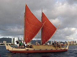
Polynesian navigation or Polynesian wayfinding was used for thousands of years to enable long voyages across thousands of kilometres of the open Pacific...
59 KB (6,995 words) - 03:51, 15 July 2025
Radio navigation or radionavigation is the application of radio waves to determine a position of an object on the Earth, either the vessel or an obstruction...
40 KB (5,315 words) - 22:23, 16 January 2025


