Waitākere Ranges. The first of these projects was the Waitākere Dam in the north-eastern Waitākere Ranges, which was completed in 1910. The Waitākere...
48 KB (4,361 words) - 10:04, 23 July 2025

Waitākere Ranges Local Board is one of the 21 local boards of the Auckland Council, and is one of the two boards overseen by the council's Waitākere Ward...
15 KB (942 words) - 06:36, 4 July 2025

originated in the Waitākere Reservoir in the Waitākere Ranges, and begins flowing northwards after leaving the Waitākere Dam. The Waitākere Falls can be found...
10 KB (876 words) - 18:04, 22 July 2025

Titirangi (category Waitākere Ranges Local Board Area)
Titirangi is a suburb of West Auckland in the Waitākere Ranges local board area of the city of Auckland in northern New Zealand. It is an affluent, residential...
29 KB (2,412 words) - 20:03, 7 July 2025

Glen Eden (category Waitākere Ranges Local Board Area)
foothills of the Waitākere Ranges. Originally known as Waikumete, the suburb gained the name Glen Eden in 1921. The suburb is in the Waitākere Ward, one of...
41 KB (3,576 words) - 03:34, 30 June 2025
Waitākere, often called Waitākere Township or Waitākere Town, is a small, mostly rural settlement to the northwest of Auckland, New Zealand. The settlement...
11 KB (943 words) - 10:03, 23 July 2025
members were elected to local boards in the 2013 Auckland local board elections, an election held as part of the 2013 New Zealand local elections. This table...
41 KB (58 words) - 04:47, 23 July 2025
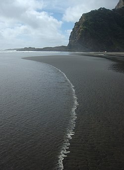
Karekare, New Zealand (category Waitākere Ranges Local Board Area)
coastal settlement in West Auckland, New Zealand, sandwiched between the Waitākere Ranges and a large black sand surf beach. It is located 35 kilometres (22 mi)...
19 KB (2,053 words) - 03:23, 5 June 2025

Swanson, New Zealand (category Waitākere Ranges Local Board Area)
Each area elects a local board, and the residents of the Waitākere Ranges and Henderson-Massey elect two councillors from the Waitākere ward to sit on the...
26 KB (2,799 words) - 21:46, 25 April 2025

Arataki Visitor Centre (category Waitākere Ranges Local Board Area)
from fallen kauri from the Waitākere Ranges. In late 2017, Te Kawerau ā Maki placed a rāhui on the tracks of the Waitākere Ranges, due to the effects of Kauri...
8 KB (724 words) - 20:50, 28 July 2024

Piha (category Waitākere Ranges Local Board Area)
coast to the north of the Manukau Harbour, on the western edge of the Waitākere Ranges. Immediately to the north of Piha is Whites Beach, and immediately...
20 KB (2,031 words) - 01:35, 1 July 2025

Anawhata (category Waitākere Ranges Local Board Area)
along the West Coast of West Auckland, between the Tasman Sea and the Waitākere Ranges. It is located south of Te Henga / Bethells Beach, and north of Piha...
5 KB (419 words) - 09:25, 28 May 2025

Fairy Falls (New Zealand) (category Waitākere Ranges Local Board Area)
The Fairy Falls are a waterfall in the eastern Waitākere Ranges of Auckland, New Zealand. The falls are a part of the Fairy Falls Stream, a stream that...
3 KB (254 words) - 15:50, 1 June 2025

Whatipu (category Waitākere Ranges Local Board Area)
the north is Karekare. Whatipu is located at the southern end of the Waitākere Ranges. Shifting sands have substantially changed the beach since the 1940s...
12 KB (1,329 words) - 18:25, 6 May 2025

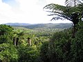
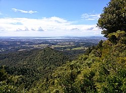
Te Toiokawharu (category Waitākere Ranges Local Board Area)
hill in the Waitākere Ranges of the Auckland Region of New Zealand's North Island. At 474-metres, it is the tallest peak of the Waitākere Ranges. The peak...
7 KB (711 words) - 19:40, 9 October 2024
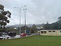
Waiatarua (redirect from Waitakere Ranges South)
Waiatarua is a small settlement near the top of the Waitākere Ranges in West Auckland, close to the junction of Scenic Drive, West Coast Road and Piha...
14 KB (1,194 words) - 17:11, 22 July 2025

Parrs Park (category Waitākere Ranges Local Board Area)
and as of 2025, is jointly governed by elected members of the Waitākere Ranges Local Board, as part of Auckland Council. The park is situated on what was...
46 KB (4,499 words) - 03:11, 29 July 2025

Laingholm (category Waitākere Ranges Local Board Area)
Laingholm is a small community situated in the Waitākere Ranges of West Auckland, New Zealand. The name is derived from George and John Laing, who farmed...
9 KB (798 words) - 11:00, 13 January 2025

Pukematekeo (category Waitākere Ranges Local Board Area)
Waitākere Ranges of the Auckland Region of New Zealand's North Island. It is located west of Henderson, and is the northernmost hill in the Waitākere...
8 KB (791 words) - 21:50, 25 April 2025

Te Henga / Bethells Beach (category Waitākere Ranges Local Board Area)
Wai-tākere ("cascading water"), which was later applied to the Waitākere River, Ranges, and West Auckland in general. In the mid 1800s, much of the area...
26 KB (2,767 words) - 03:35, 5 June 2025

Te Unuhanga-a-Rangitoto / Mercer Bay (category Waitākere Ranges Local Board Area)
cliffs above the bay. After kauri dieback led to the closure of many Waitākere Ranges tracks, the Mercer Bay Loop Track grew significantly in popularity...
6 KB (551 words) - 23:51, 28 July 2024

Te Rau-o-te-Huia / Mount Donald McLean (category Waitākere Ranges Local Board Area)
highest peak of the Waitākere Ranges that borders the Manukau Harbour. The hill is a 389 m (1,276 ft) peak in the Waitākere Ranges, approximately 2 km...
9 KB (880 words) - 19:34, 5 January 2025

Ruaotuwhenua (category Waitākere Ranges Local Board Area)
the Waitākere Ranges of the Auckland Region of New Zealand's North Island. At 440 metres (1,440 ft), it is one of the tallest of the Waitākere Ranges, and...
7 KB (593 words) - 14:14, 13 May 2025

Parau (category Waitākere Ranges Local Board Area)
Auckland in the Auckland Region. It is under the local governance of the Waitākere Ranges Local Board within the Auckland Council. It is a coastal community...
12 KB (1,167 words) - 08:03, 13 January 2025

Huia, New Zealand (category Waitākere Ranges Local Board Area)
coastal settlement in West Auckland, New Zealand and forms part of the Waitākere Ranges Regional Park. The majority of houses in Huia are located along Huia...
20 KB (1,701 words) - 03:36, 5 June 2025

Scenic Drive, Auckland (category Waitākere Ranges Local Board Area)
Scenic Drive is a road that runs through the bush-clad Waitākere Ranges from Titirangi to Swanson on the western outskirts of Auckland, New Zealand. It...
6 KB (712 words) - 04:49, 1 May 2025

Lake Kawaupaka (category Waitākere Ranges Local Board Area)
2022. Waitākere Ranges Local Board (October 2015). "Local Area Plan: Te Henga (Bethells Beach) and the Waitākere River Valley. Waitākere Ranges Heritage...
5 KB (498 words) - 06:51, 12 April 2024

further $250,000 to complete the work. Funded and supported by Waitākere Ranges Local Board the Theatre has continued to be used by their resident company...
36 KB (3,343 words) - 10:52, 2 May 2025

Waitākere Reservoir is a reservoir on the Waitakere River in the Waitākere Ranges, west of Auckland in New Zealand. The dam was completed in 1910 and...
6 KB (559 words) - 07:11, 12 April 2024

Pararaha Stream (category Waitākere Ranges Local Board Area)
Island. It flows westwards from its sources in the Waitākere Ranges through the Waitākere Ranges Regional Park, and enters the Tasman Sea at Pararaha...
9 KB (739 words) - 20:12, 10 October 2024