Department of Transport and Main Roads, and about the state-controlled roads that intersect with it. The Bruce Highway runs from Bald Hills to Cairns in...
40 KB (3,348 words) - 15:45, 4 April 2024
Department of Transport and Main Roads, and about the state-controlled roads that intersect with it. The Warrego Highway runs from Ipswich to Charleville...
23 KB (1,932 words) - 00:40, 22 January 2024
Department of Transport and Main Roads, and about the state-controlled roads that intersect with it. The Cunningham Highway runs from Goodna to Goondiwindi...
22 KB (1,802 words) - 22:38, 9 February 2024
Marlborough–Sarina Road is a state-controlled district road (number 512) rated as a local road of regional significance (LRRS). It runs from the Bruce Highway in Marlborough...
18 KB (1,471 words) - 05:56, 19 December 2023

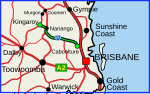
The Bruce Highway is a major highway in Queensland, Australia. Commencing in the state capital, Brisbane, it passes through areas close to the eastern...
101 KB (5,398 words) - 13:50, 10 May 2024
Department of Transport and Main Roads, and about the state-controlled roads that intersect with it. The Mount Lindesay Highway runs from Drewvale to Mount...
6 KB (516 words) - 02:20, 5 March 2024
Transport and Main Roads, and about the state-controlled roads that intersect with it. The Queensland segment of the New England Highway runs from Yarraman...
12 KB (1,052 words) - 01:05, 22 January 2024

Bay Highway is a short state highway of Queensland, Australia running between Goomeri on the Burnett Highway and a junction on the Bruce Highway. From...
8 KB (647 words) - 00:30, 21 January 2024
article. Mulgrave Road is a state-controlled regional road (number 809). It runs from the Bruce Highway in Woree to the Captain Cook Highway in Cairns City...
6 KB (528 words) - 21:15, 5 April 2024

Gavial–Gracemere Road is a state-controlled district road (number 450). It runs from the Bruce Highway in Midgee to the Capricorn Highway in Gracemere, a...
15 KB (930 words) - 06:03, 27 April 2024
Connection Road is a state-controlled district road (number 1411) rated as a local road of regional significance (LRRS). It runs from the Bruce Highway in Gympie...
14 KB (1,179 words) - 23:06, 28 March 2024
Downs Highway, and the Mackay Ring Road, the network consists of the following state-controlled roads: Glenella Connection Road Mackay–Slade Point Road Rockleigh–North...
8 KB (686 words) - 01:49, 10 February 2024

addition to the Bruce, Leichhardt, Gregory and Landsborough Highways, and the Fitzroy Developmental Road, the following state-controlled roads, from east to...
18 KB (1,323 words) - 20:53, 18 May 2024
The D'Aguilar Highway is a two-lane highway linking the Bruce Highway near Caboolture with the Bunya Highway in Kingaroy in the state of Queensland, Australia...
22 KB (1,114 words) - 05:42, 20 January 2024
following state-controlled roads intersect with this road: Eumundi–Kenilworth Road Emu Mountain Road Eumundi–Kenilworth Road is a state-controlled district...
12 KB (1,026 words) - 23:20, 8 May 2024
Maryland highway system has several hundred former state highways. These highways were constructed, maintained, or funded by the Maryland State Roads Commission...
104 KB (12,452 words) - 18:24, 21 August 2023
state-controlled district road (number 837). It runs from Bruce Highway exit and entry ramps in Douglas to the Douglas–Garbutt Road (University Road)...
28 KB (2,361 words) - 08:55, 6 May 2024
district road (number 914). Known as Old Bruce Highway, It runs from Cooroy Connection Road on the Black Mountain / Pomona midpoint to the Bruce Highway in...
10 KB (693 words) - 01:31, 31 October 2023

Highways and main roads in the Wheatbelt region of Western Australia form the basis of a road network, which is primarily used by the mining, agriculture...
44 KB (2,661 words) - 02:22, 11 May 2024
Maryland highway system has several hundred former state highways. These highways were constructed, maintained, or funded by the Maryland State Roads Commission...
72 KB (8,399 words) - 01:10, 30 October 2023
This road intersects with the following state-controlled roads: Homebush Road Peak Downs Highway Mirani–Eton Road North Eton Road Mackay–Eungella Road Homebush...
12 KB (1,021 words) - 21:30, 1 April 2024

currently leading a project to replace the controlled intersection at MN 36 and County State-Aid Highway 17 (CSAH 17, Lake Elmo Avenue) in Grant and...
24 KB (2,170 words) - 03:23, 27 May 2024
state highways in Maryland shorter than one mile (1.6 km) in length with route numbers between 2 and 699. Most of these highways act as service roads...
89 KB (7,809 words) - 21:37, 4 May 2024
Wallaville, this road was part of the Bruce Highway. This road intersects with the following state-controlled roads: Isis Highway Moore Park Road Bundaberg–Miriam...
12 KB (1,025 words) - 06:36, 14 December 2023

the Bruce, Burnett, Leichhardt, Carnarvon and Gregory Highways, and the Fitzroy and Dawson Developmental Roads, the following state-controlled roads, from...
20 KB (1,305 words) - 02:29, 29 April 2024
of the following state-controlled roads: Brighton–Redcliffe Road (see below for component bridges and roads) Clontarf–Anzac Avenue Road (Elizabeth Avenue...
12 KB (1,137 words) - 18:45, 23 April 2024
Bli Bli before reaching the Bruce Highway, which it passes under at a dumbbell intersection. It runs southeast as State Route 10, and then northeast...
11 KB (732 words) - 23:27, 8 May 2024
highways act as service roads, old alignments of more prominent highways, or connectors between one or more highways. Many of these highways are unsigned and...
96 KB (8,306 words) - 02:37, 5 May 2024
Dawson Highway, the network consists of the following state-controlled roads: Gladstone–Benaraby Road Boyne Island Road Gladstone Port Access Road Gladstone–Mount...
3 KB (267 words) - 00:03, 5 March 2024
highways act as service roads, old alignments of more prominent highways, or connectors between one or more highways. Many of these highways are unsigned and...
97 KB (8,242 words) - 21:28, 4 May 2024