
A satellite navigation or satnav system is a system that uses satellites to provide autonomous geopositioning. A satellite navigation system with global...
44 KB (4,550 words) - 11:44, 15 May 2025
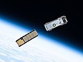
Galileo is a global navigation satellite system (GNSS) created by the European Union through the European Space Agency (ESA) and operated by the European...
104 KB (10,185 words) - 12:18, 21 May 2025

A satellite navigation (satnav) device or GPS device is a device that uses satellites of the Global Positioning System (GPS) or similar global navigation...
39 KB (4,142 words) - 23:23, 17 April 2025

Indian Regional Navigation Satellite System (IRNSS), with an operational name of NavIC (acronym for Navigation with Indian Constellation; also, nāvik 'sailor'...
63 KB (5,276 words) - 11:26, 20 March 2025
BeiDou (redirect from Beidou satellite navigation system)
The BeiDou Navigation Satellite System (BDS; Chinese: 北斗卫星导航系统; pinyin: běidǒu wèixīng dǎoháng xìtǒng) is a satellite-based radio navigation system owned...
67 KB (5,855 words) - 03:24, 17 April 2025
Satellite navigation software or GNSS navigation software a category of software that provide positioning services by utilizing data from satellite navigation...
6 KB (589 words) - 05:06, 25 March 2025
GLONASS (redirect from GLObal NAvigation Satellite System)
lit. 'Global Navigation Satellite System') is a Russian satellite navigation system operating as part of a radionavigation-satellite service. It provides...
72 KB (6,243 words) - 04:16, 16 May 2025
The Global Positioning System (GPS) is a satellite-based hyperbolic navigation system owned by the United States Space Force and operated by Mission Delta...
185 KB (19,124 words) - 16:20, 13 May 2025

The field of navigation includes four general categories: land navigation, marine navigation, aeronautic navigation, and space navigation. It is also the...
82 KB (9,369 words) - 16:49, 21 April 2025
European Satellite Navigation Industries, formerly called Galileo Industries until legal action prompted a name change, was a joint venture of the companies...
3 KB (317 words) - 04:22, 2 February 2025
Satellite navigation solution for the receiver's position (geopositioning) involves an algorithm. In essence, a GNSS receiver measures the transmitting...
13 KB (1,920 words) - 11:40, 2 January 2025
GNSS augmentation (redirect from Satellite navigation augmentation system)
Augmentation of a global navigation satellite system (GNSS) is a method of improving the navigation system's attributes, such as precision, reliability...
15 KB (1,588 words) - 13:54, 20 April 2025

Celestial navigation is performed without using satellite navigation or other similar modern electronic or digital positioning means. Celestial navigation uses...
39 KB (5,086 words) - 03:38, 8 May 2025

military satellite is an artificial satellite used for a military purpose. The most common missions are intelligence gathering, navigation and military...
17 KB (1,592 words) - 17:49, 7 January 2025

NNSS (for Navy Navigation Satellite System), was the first satellite navigation system to be used operationally. The radio navigation system was primarily...
32 KB (3,712 words) - 16:21, 2 March 2025

Michibiki (みちびき, "guidance"), is a four-satellite regional satellite navigation system and a satellite-based augmentation system developed by the Japanese government...
23 KB (1,908 words) - 01:40, 26 February 2025

Differential GPS (redirect from Differential satellite navigation)
supplement and enhance the positional data available from global navigation satellite systems (GNSSs). A DGPS can increase accuracy of positional data...
26 KB (2,943 words) - 22:01, 14 April 2025
The GPS-aided GEO augmented navigation (GAGAN) is an implementation of a regional satellite-based augmentation system (SBAS) by the Government of India...
24 KB (2,667 words) - 03:41, 24 March 2025

GPS satellite blocks are the various production generations of the Global Positioning System (GPS) used for satellite navigation. The first satellite in...
15 KB (1,558 words) - 08:27, 31 March 2025
the first Soviet satellite navigation system, developed in the former Soviet Union. From 1967 to 1978 a total of 31 Zaliv satellites were launched onboard...
1 KB (105 words) - 21:20, 3 April 2025
remote places. The signal delay from satellites and their orbit's predictability are used in satellite navigation systems, such as GPS. Crewed spacecrafts...
61 KB (6,426 words) - 17:26, 27 April 2025

navigation system is part of the automobile controls or a third party add-on used to find direction in an automobile. It typically uses a satellite navigation...
21 KB (2,335 words) - 22:46, 5 May 2025
This is a list of notable commercial satellite navigation software (also known as GPS software) for various devices, with a specific focus on mobile phones...
16 KB (246 words) - 07:10, 7 May 2025
aircraft, and reduces sortie times. It uses both GLONASS satellite navigation and internal navigation systems, improving accuracy over extended distances....
10 KB (727 words) - 18:40, 16 May 2025

The European Geostationary Navigation Overlay Service (EGNOS) is a satellite-based augmentation system (SBAS) developed by the European Space Agency and...
18 KB (1,748 words) - 14:46, 17 February 2025

Geostationary orbit (redirect from Geostationary satellite)
located. Weather satellites are also placed in this orbit for real-time monitoring and data collection, as are navigation satellites in order to provide...
49 KB (4,893 words) - 06:24, 20 May 2025

needed] Satellite navigation systems send several signals that are used to decode the satellite's position, distance between the user satellite, and the...
40 KB (5,315 words) - 22:23, 16 January 2025

Sputnik 1 (redirect from First artificial satellite)
of Sputnik also planted the seeds for the development of modern satellite navigation. Two American physicists, William Guier and George Weiffenbach, at...
79 KB (8,409 words) - 23:57, 17 May 2025

European Union Agency for the Space Programme (redirect from European Global Navigation Satellite System Supervisory Authority)
European Global Navigation Satellite Systems Supervisory Authority (GSA) in 2004, reorganised into the European Global Navigation Satellite Systems Agency...
16 KB (1,685 words) - 20:35, 11 May 2025
TERCOM (redirect from TERCOM-Aided Inertial Navigation System)
Terrain contour matching, or TERCOM, is a navigation system used primarily by cruise missiles. It uses a contour map of the terrain that is compared with...
12 KB (1,701 words) - 20:43, 17 May 2025