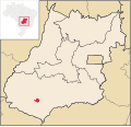
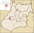
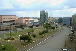
Aparecida do Rio Doce is a municipality in southwest Goiás state, Brazil. The municipality of Aparecida do Rio Doce belongs to the Sudoeste de Goiás Microregion...
5 KB (415 words) - 14:39, 7 May 2024
R$46.632.000 billion Anápolis - R$13.301.000 billion Aparecida de Goiânia - R$11.518.000 billion Rio Verde - R$8.078.000 billion Catalão - R$5.679.000 billion...
19 KB (1,894 words) - 21:10, 28 June 2025

most populous municipality is Rio Verde with 149,3821 inhabitants (2007). The least populous is Aparecida do Rio Doce with 2,702 inhabitants (2007)....
3 KB (188 words) - 00:13, 21 September 2021
Nossa Senhora Aparecida, a municipality in Sergipe, Brazil Aparecida de Goiânia, a municipality in Goiás, Brazil Aparecida do Rio Doce, a municipality...
690 bytes (121 words) - 19:52, 16 May 2016

mainly cerrado, with some residual forests. The bordering cities are Aparecida do Rio Doce, Cachoeira Alta, Caiapônia, Castelândia, Jataí, Maurilândia, Montividiu...
13 KB (1,020 words) - 09:59, 27 December 2024

Carmo do Rio Verde is a municipality in central Goiás state, Brazil. The population was 8,897 (2007) in a total area of 457.5 km2. Carmo do Rio Verde...
5 KB (406 words) - 23:42, 12 March 2025

the entrance to the city Rivers that cross the municipality are: Rio Vermelho, Urú, do Peixe, Ferreira and Índio Eligible voters: 17,813 (2016) Mayor:...
19 KB (1,380 words) - 23:52, 2 April 2025

the mouth of the Paraíba do Sul and Doce Rivers, but it may already be extinct. Other threatened species in the Paraíba do Sul basin are the bivalves...
12 KB (1,248 words) - 09:28, 17 January 2025
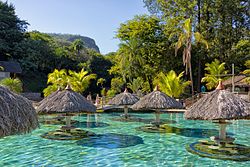
Rio Quente (Brazilian Portuguese: [ˈʁi.u ˈkẽtʃi]; "Hot River") is a municipality in the south of the state of Goiás, Brazil. It is the site of a hot water...
7 KB (631 words) - 00:15, 13 March 2025

Pires do Rio is a municipality in Goiás state, Brazil. It is a prosperous town and a major producer of poultry. It is located in the Pires do Rio Microregion...
7 KB (658 words) - 00:40, 13 March 2025

Caldas Novas (section Rio Quente)
Santa Cruz de Goiás and Piracanjuba South: Corumbaíba East: Ipameri West: Rio Quente and Morrinhos The city and region are served by Nelson Ribeiro Guimarães...
11 KB (1,165 words) - 14:03, 25 March 2025

Bulhões and Silvânia. It is in the Pires do Rio Microregion and has boundaries with Orizona, Pires do Rio, São Miguel do Passa Quatro and Silvânia. Mayor: Antônio...
5 KB (329 words) - 00:44, 13 March 2025

Paranaiguara Quirinópolis São Simão Sudoeste de Goias Aparecida do Rio Doce Aporé Caiapônia Castelândia Chapadão do Céu Doverlândia Jataí Maurilândia Mineiros Montividiu...
36 KB (99 words) - 14:44, 2 March 2025

BR-352 / Bela Vista de Goiás / Cristianópolis / GO-020 / BR-352 / Pires do Rio / GO-330 / Ipameri. Municipal boundaries are with: North: Campo Alegre de...
16 KB (1,295 words) - 05:22, 9 July 2025

Adelândia, Turvânia, Firminópolis, Aurilândia, Sanclerlândia and Córrego do Ouro. The distance to Goiânia is 129 km. Highway communications are made by...
6 KB (618 words) - 18:27, 20 February 2022

Veadeiros National Park, already mentioned; the Maytreia Garden; the Canyon of Rio Preto (black river); Sertão Zen; Baleia Hill (the whale hill, because of...
15 KB (1,597 words) - 11:38, 27 December 2024

Planaltina is part of micro-region 12 of the state, the so-called Entorno do Distrito Federal. It borders Água Fria de Goiás, Formosa, Mimoso de Goiás...
8 KB (652 words) - 19:59, 9 March 2023

Mochileiro Tur. Retrieved 11 November 2010. "Bacia do rio Paranaíba". Secretaria de Planejamento do estado de Goiás (SEPLAN-Goiás). Archived from the original...
70 KB (6,114 words) - 20:48, 11 July 2025

Antônio da Barra / Rio Verde. See Sepin Geographical limits: Caiapônia, Mineiros, Itarumã, Aparecida do Rio Doce, Caçu, Cachoeira Alta, Rio Verde, Mineiros...
12 KB (1,032 words) - 04:29, 31 January 2024

Atlantic coast in the state of Rio Grande do Sul. The city's landscape is distinguished as the only beach in Rio Grande do Sul featuring prominent rocky...
128 KB (14,316 words) - 20:26, 11 July 2025

North: Piracanjuba South: Buriti Alegre and Goiatuba East: Caldas Novas, Rio Quente, and Água Limpa West: Joviânia, Aloândia, and Pontalina Mayor: Rogério...
11 KB (1,202 words) - 00:12, 13 March 2025

and states are: north: Tocantins south: Alto Paraíso de Goiás west: Colinas do Sul and Minaçu east: Teresina de Goiás The first settlers arrived in the region...
7 KB (693 words) - 00:03, 13 March 2025

Rio Verde / GO-174 / GO-422 / Aparecida do Rio Doce / BR-364. See Sepin Neighboring municipalities are: north and east: Quirinópolis and Aparecida do...
6 KB (465 words) - 18:27, 20 February 2022

Trinidade, Goias". PaddockTalk. 8 September 2014. Frigoletto Sepin Portal do Governo Municipal de Trindade Web Trindade - News and photos about Trindade/GO...
8 KB (784 words) - 05:42, 9 August 2024
Arenópolis. There are low mountains: Serra do Caiapó, Serra dos Pilões, Serra do Rio Claro, and Morro do Macaco, where there are deposits of nickel....
7 KB (576 words) - 13:48, 1 June 2025
Paranaiguara Quirinópolis São Simão Sudoeste de Goias Aparecida do Rio Doce Aporé Caiapônia Castelândia Chapadão do Céu Doverlândia Jataí Maurilândia Mineiros Montividiu...
5 KB (366 words) - 23:08, 12 March 2025

Municipal boundaries are with Itapaci, Nova Glória, São Patrício, Carmo do Rio Verde, Rialma and Rubiataba. Highway links are made by GO-080 / Nerópolis...
7 KB (590 words) - 04:22, 16 December 2024

Minas Sul/Sudoeste de Minas Triângulo Mineiro/Alto Paranaiba Vale do Mucuri Vale do Rio Doce Zona da Mata Geography of Brazil List of cities in Brazil...
24 KB (88 words) - 22:14, 14 January 2024
Rio Verde, 99 km away. Highway connections from Goiânia are by BR-060 / Guapó / Indiara / Acreúna / Rio Verde / GO-174/GO-422 / Aparecida do Rio Doce...
6 KB (514 words) - 00:56, 13 March 2025

Central, southwest of Brasília and is part of the area known as the Entorno do Distrito Federal. The distance to the state capital, Goiânia, is 188 km and...
6 KB (530 words) - 13:44, 18 July 2025