Brithdir and Llanfachreth is a community in the county of Gwynedd, Wales, near Dolgellau, and is 93.1 miles (149.8 km) from Cardiff and 178.4 miles (287...
3 KB (143 words) - 01:13, 4 February 2025

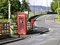
Brithdir is a small hamlet on the outskirts of Dolgellau, Gwynedd in the community of Brithdir and Llanfachreth. The Arts and Crafts Movement St Mark's...
2 KB (80 words) - 12:57, 15 February 2025

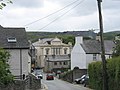
Llanfachreth is a village approximately three miles north-east of Dolgellau, Gwynedd, in the community of Brithdir and Llanfachreth within the historic...
18 KB (2,029 words) - 13:04, 15 February 2025

Dwyfor Meirionnydd (UK Parliament constituency) (redirect from Dwyfor and Meirionydd)
Botwnnog, Bowydd and Rhiw, Brithdir and Llanfachreth/Ganllwyd/Llanelltyd, Bryn-crug/Llanfihangel, Clynnog, Corris/Mawddwy, Criccieth, Diffwys and Maenofferen...
22 KB (917 words) - 08:10, 15 April 2025

Nannau Hall (category Registered historic parks and gardens in Gwynedd)
'the place of many streams'') is a Georgian mansion and estate near the village of Llanfachreth, Gwynedd, North Wales. The mansion was initially inhabited...
37 KB (4,302 words) - 14:51, 11 March 2025

Aran Fawddwy (category Brithdir and Llanfachreth)
Snowdonia above 900m, and higher than anywhere in the United Kingdom outside Northern Snowdonia, the Scottish Highlands (and islands) and the Lake District...
7 KB (555 words) - 03:39, 5 May 2025
on 7 June 2011, retrieved 31 July 2010 St Mark's Church, Brithdir, Brithdir and Llanfachreth, British Listed Buildings, retrieved 31 July 2010 Bayley...
11 KB (981 words) - 21:49, 14 February 2024

Gwynedd Council (redirect from Caernarfonshire and Merionethshire council)
administrative counties of Anglesey, Caernarfonshire, most of Merioneth, and a small part of Denbighshire. The new county created in 1974 was named "Gwynedd"...
30 KB (2,141 words) - 20:41, 3 May 2025
Snowdonia National Park) List of places in Gwynedd for all villages, towns and cities in Gwynedd. "The County of Gwynedd (Electoral Changes) Order 2002...
4 KB (123 words) - 18:32, 21 March 2022

Waun Camddwr (category Brithdir and Llanfachreth)
between the summits of Aran Fawddwy and Glasgwm. It was surveyed after the first Nuttall list was compiled, and found to have just enough prominence...
2 KB (138 words) - 09:06, 3 May 2024

Pen y Brynfforchog (category Brithdir and Llanfachreth)
summit is bare and marked by a few stones. The views to the Dyfi hills: include direct view of the Craig Portas ridge, with Maesglase and Cribin Fawr. Nuttall...
2 KB (116 words) - 04:19, 5 May 2025

Bont Newydd railway station (category Brithdir and Llanfachreth)
Originally a single-line station, a crossing loop was installed in 1923 and a second platform constructed out of old sleepers. A corrugated iron shelter...
3 KB (235 words) - 07:01, 15 March 2025

Wnion Halt railway station (category Brithdir and Llanfachreth)
(2002). Railway passenger stations in England, Scotland and Wales – a chronology. Richmond: Railway and Canal Historical Society. p. 462. OCLC 931112387. Mitchell...
3 KB (176 words) - 06:50, 15 March 2025

Cribin Fawr (category Brithdir and Llanfachreth)
the west is Waun-oer, to the north Cadair Idris, to the south Maesglase and Glasgwm to the east. Nuttall, John & Anne (1999). The Mountains of England...
2 KB (119 words) - 04:52, 18 February 2024

Drws-y-Nant railway station (category Brithdir and Llanfachreth)
this station in 1956: G, P, L & H and there was no crane. Part of the station survives today with two whole platforms, and a nearby crossing cottage. The...
3 KB (168 words) - 23:00, 8 December 2024

Rhobell Fawr (category Brithdir and Llanfachreth)
Goriwared, a couple of miles north-north-east of the small village of Llanfachreth. Geoscience Wales (2015). "Rhobell Fawr: The First Signs of Ordovician...
3 KB (125 words) - 21:03, 17 September 2024

"Election results for Bowydd and Rhiw". Gwynedd Council. Retrieved 8 May 2022. "Election results for Brithdir and Llanfachreth / Y Ganllwyd / Llanelltyd"...
56 KB (1,065 words) - 12:21, 11 January 2025

Glasgwm (category Brithdir and Llanfachreth)
make up the range, the others being Aran Fawddwy and Esgeiriau Gwynion. To the west is Maesglase and the Dyfi hills, while to the south-west lies Cadair...
3 KB (195 words) - 03:55, 5 May 2025

Dolserau Halt railway station (category Brithdir and Llanfachreth)
The platform edge was made of timber and was situated on the north side of the line. It had a timber shelter and a name-board with the suffix "FOR THE...
2 KB (140 words) - 22:55, 8 December 2024
Barmouth (town) Beddgelert Bethesda Betws Garmon Bontnewydd Botwnnog Brithdir and Llanfachreth Bryn-crug Buan Caernarfon (royal town) Clynnog Corris Criccieth...
112 KB (5,623 words) - 19:39, 19 April 2025

Waun-oer (category Brithdir and Llanfachreth)
of Maesglase and the summit consists of a trig point that crowns an uneven grassy plateau. It is connected to Cribin Fawr to the east and Mynydd Ceiswyn...
2 KB (122 words) - 19:47, 11 July 2024
Bethesda, Gwynedd (section Commerce and industry)
(/bɛˈθɛzdə/; Welsh: [bɛθ'ɛsda]) is a town and community in Gwynedd, Wales. It is on the banks of Afon Ogwen and on the edge of Snowdonia. It is about 5...
17 KB (1,821 words) - 08:18, 19 April 2025

"Election results for Bowydd and Rhiw". Gwynedd County Council. Retrieved 3 June 2019. "Election results for Brithdir and Llanfachreth / Y Ganllwyd / Llanelltyd"...
55 KB (965 words) - 07:02, 5 December 2024

Sarn Helen (category Brithdir and Llanfachreth)
still traceable. However, there are sizeable stretches that have been lost and are unidentifiable. The route is named after Saint Elen of Caernarfon, a...
8 KB (808 words) - 11:13, 26 January 2024

Allt y Benglog National Nature Reserve (category Brithdir and Llanfachreth)
combination of numerous waterfalls and good tree coverage, and allows an unusually rich variety of moisture-loving mosses, plants and trees to thrive. "Allt y Benglog...
1 KB (111 words) - 16:15, 5 April 2021

Drws-y-Nant (category Brithdir and Llanfachreth)
Drws-y-Nant is a village in Gwynedd, Wales, located between Dolgellau and Bala. It was formerly served by the Drws-y-Nant railway station but this closed...
2 KB (59 words) - 00:24, 20 February 2025
MACHREATH'S CHURCH, LLANFACHRETH | Coflein". www.coflein.gov.uk. Retrieved 2017-07-21. "FFRWD,Y, INDEPENDENT CHAPEL (SILOH), LLANFACHRETH | Coflein". www...
159 KB (5,592 words) - 02:13, 4 May 2025

elections to Gwynedd County Council Ganllwyd is part of a combined Brithdir and Llanfachreth/Ganllwyd/Llanelltyd electoral ward. Wikimedia Commons has media...
5 KB (381 words) - 23:50, 5 April 2025
List of works by Clough Williams-Ellis (category Lists of buildings and structures by architect)
[PA442/15(1-3)], demolished 2006 to make way for new building Brithdir and Llanfachreth Braich y Ceunant: Design for alterations & additions to house...
52 KB (7,600 words) - 21:57, 10 February 2025
List of prehistoric scheduled monuments in Gwynedd (former Merionethshire) (category Buildings and structures in Gwynedd)
Wales. The northern half includes the high mountains of Snowdonia and the mixed farmland and hills of the Llŷn Peninsula, which between them make up the historic...
114 KB (3,560 words) - 10:49, 21 September 2024