
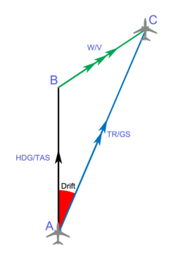
In navigation, the course of a watercraft or aircraft is the cardinal direction in which the craft is to be steered. The course is to be distinguished...
5 KB (361 words) - 21:21, 11 January 2025

The field of navigation includes four general categories: land navigation, marine navigation, aeronautic navigation, and space navigation. It is also the...
83 KB (9,369 words) - 14:32, 23 May 2025

In navigation, bearing or azimuth is the horizontal angle between the direction of an object and north or another object. The angle value can be specified...
15 KB (1,960 words) - 07:26, 6 March 2025
Look up course, 'course, or courses in Wiktionary, the free dictionary. Course may refer to: Course (navigation), the path of travel Course (orienteering)...
2 KB (345 words) - 18:38, 10 September 2024

Great-circle navigation or orthodromic navigation (related to orthodromic course; from Ancient Greek ορθός (orthós) 'right angle' and δρόμος (drómos) 'path')...
22 KB (4,006 words) - 15:40, 28 March 2025

Proportional navigation (also known as PN or Pro-Nav) is a guidance law (analogous to proportional control) used in some form or another by most homing...
9 KB (1,188 words) - 17:42, 20 March 2025

A course deviation indicator (CDI) is an avionics instrument used in aircraft navigation to determine an aircraft's lateral position in relation to a course...
5 KB (661 words) - 10:51, 1 February 2025
segment where an aircraft can be assured of receiving signals from off-course navigation aids like VOR that define a fix. An MRA is determined by FAA flight...
1 KB (146 words) - 01:05, 31 December 2023
also refer to: Bicycle path Bridle path, used by people on horseback Course (navigation), the intended path of a vehicle Desire path, created by human or...
3 KB (416 words) - 14:05, 13 November 2024

Celestial navigation, also known as astronavigation, is the practice of position fixing using stars and other celestial bodies that enables a navigator...
39 KB (5,086 words) - 03:38, 8 May 2025

Dead reckoning (category Navigation)
In navigation, dead reckoning is the process of calculating the current position of a moving object by using a previously determined position, or fix,...
27 KB (3,572 words) - 11:05, 27 May 2025

Rhumb line (category Navigation)
constant azimuth (bearing as measured relative to true north). Navigation on a fixed course (i.e., steering the vessel to follow a constant cardinal direction)...
21 KB (2,870 words) - 08:32, 14 January 2025

Marine navigation is the art and science of steering a ship from a starting point (sailing) to a destination, efficiently and responsibly. It is an art...
30 KB (2,841 words) - 09:03, 25 May 2025
The most common use of the TVMDC method is deriving compass courses during nautical navigation from maps. The inverse correction from compass heading to...
9 KB (1,217 words) - 02:48, 2 February 2025

Low-frequency radio range (redirect from Cone of silence (navigation))
the four-course radio range, LF/MF four-course radio range, A-N radio range, Adcock radio range, or commonly "the range", was the main navigation system...
31 KB (3,349 words) - 17:54, 10 January 2025

Azimuth (category Navigation)
Azimuthal equidistant projection Azimuth recording Bearing (navigation) Clock position Course (navigation) Inclination Longitude Latitude Magnetic declination...
14 KB (1,767 words) - 17:57, 28 May 2025

the course within the 4-hour time frame. Examples of events include rappelling, building and crossing a one-rope bridge, obstacle course navigation, combat...
10 KB (1,169 words) - 13:16, 8 May 2025
Look up navigation in Wiktionary, the free dictionary. Navigation is the theory and practice of navigating, especially the charting of a course for a ship...
2 KB (231 words) - 15:18, 19 April 2024
according to the Mercator projection, a loxodromic course appears as a straight line. Great circle navigation Windrose network Map Portolan map Marine sandglass...
2 KB (165 words) - 00:01, 15 April 2022
2015-08-15. Pratt, Jeremy M. (2003) [1996]. The Private Pilot's Licence Course: Navigation, Meteorology (3rd ed.). met22 – met23. ISBN 1-874783-18-7. AGL in...
7 KB (778 words) - 10:46, 27 May 2025
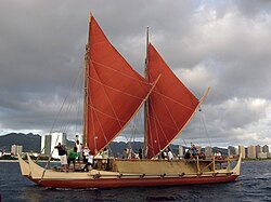
Polynesian navigation or Polynesian wayfinding was used for thousands of years to enable long voyages across thousands of kilometres of the open Pacific...
59 KB (6,995 words) - 19:59, 23 May 2025

River Great Ouse (redirect from Ouse Navigation Act 1790)
important both for drainage and for navigation for centuries, and these dual roles have not always been complementary. The course of the river has changed significantly...
42 KB (4,865 words) - 21:37, 13 May 2025
the concept of "off-course navigation" (steering to one side so you know which way the error is) is probably as old as navigation, Chichester was the...
16 KB (2,118 words) - 13:24, 21 April 2025

Area navigation (RNAV, usually pronounced as /ˈɑːrnæv/) is a method of instrument flight rules (IFR) navigation that allows aircraft to fly along a desired...
11 KB (1,326 words) - 09:50, 14 February 2025

The Mersey and Irwell Navigation was a river navigation in North West England, which provided a navigable route from the Mersey estuary to Salford and...
12 KB (1,188 words) - 15:01, 22 March 2025
Piloting (redirect from Directing (navigation))
Divers use related techniques for underwater navigation. Depending on whether one is navigating on a water course, in the air or on land, a different chart...
17 KB (1,837 words) - 10:56, 23 May 2025

satellite navigation (satnav) device or GPS device is a device that uses satellites of the Global Positioning System (GPS) or similar global navigation satellite...
39 KB (4,142 words) - 23:23, 17 April 2025

the course of the river, much of it followed secondary streams. New undertakers were not appointed as old ones died, and by 1767, the navigation was effectively...
43 KB (5,903 words) - 01:06, 13 September 2024
Plotter (instrument) (category Navigational equipment)
rulers plotter The triangle The Breton plotter Yeoman plotter Course (navigation) "Plotting course with a plotter". Archived from the original on 2009-02-24...
1 KB (73 words) - 04:51, 29 March 2023

competition for the course. Students have the opportunity to retake written exams, the 12 mile road march, and the land navigation course, and successful...
20 KB (2,304 words) - 00:41, 15 April 2025