
Geophysical imaging (also known as geophysical tomography) is a minimally destructive geophysical technique that investigates the subsurface of a terrestrial...
7 KB (732 words) - 15:34, 2 February 2025

In archaeology, geophysical survey is ground-based physical sensing techniques used for archaeological imaging or mapping. Remote sensing and marine surveys...
19 KB (2,215 words) - 09:55, 6 December 2024

An imaging spectrometer is an instrument used in hyperspectral imaging and imaging spectroscopy to acquire a spectrally-resolved image of an object or...
17 KB (2,348 words) - 17:08, 9 September 2024

Document imaging, replicating documents commonly used in business Geophysical imaging Industrial process imaging Medical imaging, creating images of the...
9 KB (990 words) - 04:17, 2 June 2025

Electrical resistivity tomography (redirect from Electrical resistivity imaging)
resistivity tomography (ERT) or electrical resistivity imaging (ERI) is a geophysical technique for imaging sub-surface structures from electrical resistivity...
12 KB (1,389 words) - 03:45, 30 April 2025
Induced polarization (category Geophysical imaging)
Induced polarization (IP) is a geophysical imaging technique used to identify the electrical chargeability of subsurface materials, such as ore. The polarization...
7 KB (595 words) - 19:26, 9 November 2024

Ground-penetrating radar (category Geophysical imaging)
Ground-penetrating radar (GPR) is a geophysical method that uses radar pulses to image the subsurface. It is a non-intrusive method of surveying the sub-surface...
33 KB (4,633 words) - 03:06, 26 May 2025
Transient electromagnetics (category Geophysical imaging)
Reflection seismology Electrical resistivity tomography, another geophysical technique of imaging SNMR Nabighian, M.N., 1979, Quasi-static Transient Response...
4 KB (526 words) - 01:23, 30 September 2023
Seismic tomography (category Geophysical imaging)
(July 1967). "Numerical Applications of a Formalism for Geophysical Inverse Problems". Geophysical Journal International. 13 (1–3): 247–276. Bibcode:1967GeoJ...
54 KB (6,134 words) - 15:54, 22 May 2025

Tomography (redirect from Tomographic imaging)
Chemical imaging 3D reconstruction Discrete tomography Geometric tomography Geophysical imaging Industrial computed tomography Johann Radon Medical imaging Network...
19 KB (1,694 words) - 05:11, 17 January 2025

Seismic interferometry (category Geophysical imaging)
Kyle, P.R. (2012). "Imaging of Erebus volcano using body wave seismic interferometry of Strombolian eruption coda". Geophysical Research Letters. 39...
18 KB (2,238 words) - 15:15, 23 May 2025

Hydrocarbon indicator (category Geophysical imaging)
In reflection seismology, a hydrocarbon indicator (HCI) or direct hydrocarbon indicator (DHI) is an anomalous seismic attribute value or pattern that could...
2 KB (213 words) - 09:02, 9 November 2024

The Geophysical Tomography Group was part of the Institut de Physique du Globe de Paris (Jussieu Campus). During the years 1985-2000 it made developments...
2 KB (194 words) - 01:25, 2 May 2020
Electrode array (category Geophysical imaging)
Loke, Meng Heng (2004-07-26) [1996]. Tutorial: 2-D and 3-D electrical imaging surveys. Archived from the original (PDF) on 2007-09-27. Retrieved 2007-06-11...
3 KB (307 words) - 08:00, 6 July 2024
Identity preserved, an agricultural designation Induced polarization, a geophysical imaging technique Intercept point, a measure in amplifiers and mixers Ion...
4 KB (451 words) - 22:29, 17 March 2025
Spectral induced polarisation (category Geophysical imaging)
or complex resistivity (CR) and also complex conductivity (CC), is a geophysical survey technique and an extension of the induced polarization (IP) method...
2 KB (145 words) - 14:17, 16 January 2022

Magnetic survey (archaeology) (category Geophysical imaging)
used in both terrestrial and marine archaeology. Magnetometers used in geophysical survey may use a single sensor to measure the total magnetic field strength...
10 KB (1,174 words) - 02:00, 27 May 2025
Electrical resistance survey (category Geophysical imaging)
structures. Electrical resistance surveying is one of the most popular geophysical methods thanks to the fact it is a nondestructive and economically favorable...
8 KB (946 words) - 16:33, 18 January 2025

appeared to be a subterranean tomb using aerial photographs and geophysical imaging tools on a ridge between two other pyramids. The ridge had long been...
4 KB (446 words) - 00:29, 15 March 2025
Radioglaciology (category Geophysical imaging)
ISSN 0022-1430. Maurer, Hansruedi; Hauck, Christian (2007). "Geophysical imaging of alpine rock glaciers". Journal of Glaciology. 53 (180): 110–120...
68 KB (6,907 words) - 11:48, 22 May 2025
Subsurface mapping by ambient noise tomography (category Geophysical imaging)
but are not limited to borehole drilling, foundation construction and geophysical surveys. Shoreline reclamation has been actively carried out by many...
18 KB (2,039 words) - 00:08, 23 May 2025
J.; Stock, G. M.; Greenwood, W. J. (1 May 2015). "Near-Surface Geophysical Imaging of a Talus Deposit in Yosemite Valley, California". Environmental...
22 KB (2,618 words) - 06:42, 1 June 2025
Here are the key details: Company Overview: Name: ION Geophysical Corporation Industry: Geophysical solutions for oil and gas Headquarters: Houston, Texas...
12 KB (1,219 words) - 21:05, 15 October 2024
Life sciences based on drill cores, borehole imaging, observatory data, and related geophysical imaging obtained from beneath the ocean floor using specialized...
11 KB (1,257 words) - 04:58, 25 March 2025
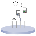
Vertical electrical sounding (category Geophysical imaging)
Vertical electrical sounding (VES) is a geophysical method for investigation of a geological medium. The method is based on the estimation of the electrical...
3 KB (334 words) - 11:18, 16 June 2022

Fiducial marker (redirect from Image fiducial mark)
needed] Airborne geophysical surveys also use the term "fiducial" as a sequential reference number in the measurement of various geophysical instruments during...
17 KB (1,957 words) - 07:04, 18 May 2025

302–303. ISBN 978-3-030-54633-5. Obi, Jeremiah Chukwunonso (2016). Geophysical Imaging of Karst Features in Missouri (PhD). Missouri University of Science...
3 KB (287 words) - 19:54, 8 March 2025

Magnetotellurics (category Geophysical imaging)
Magnetotellurics (MT) is an electromagnetic geophysical method for inferring the earth's subsurface electrical conductivity from measurements of natural...
35 KB (3,753 words) - 15:56, 23 May 2025
geologic materials and affect geophysical signatures. The activities of the microbes are measured using geophysical imaging techniques. A lot of these techniques...
3 KB (285 words) - 00:10, 2 January 2021
Atmospheric Chemistry Suite (category Geophysical imaging)
The Atmospheric Chemistry Suite (ACS) is a science payload consisting of three infrared spectrometer channels aboard the ExoMars Trace Gas Orbiter (TGO)...
8 KB (650 words) - 00:19, 11 October 2024