Spatial analysis software is software written to enable and facilitate spatial analysis. Currently, there are several packages, both free software and...
15 KB (58 words) - 09:37, 6 May 2025
Spatial analysis is any of the formal techniques which study entities using their topological, geometric, or geographic properties, primarily used in Urban...
62 KB (9,958 words) - 19:09, 5 June 2025
revolution of geography began writing computer programs to perform spatial analysis, especially at the University of Washington and the University of Michigan...
26 KB (2,782 words) - 17:47, 8 April 2025
SaTScan (category Spatial analysis)
SaTScan is a software tool that employs scan statistics for the spatial and temporal analysis of clusters of events. The software is trademarked by Martin...
11 KB (1,142 words) - 14:48, 26 December 2024
In geographic information systems (GIS) and spatial analysis, buffer analysis is the determination of a zone around a geographic feature containing locations...
6 KB (714 words) - 04:55, 28 November 2023
lines. The digital representation of these networks, and the methods for their analysis, is a core part of spatial analysis, geographic information systems...
13 KB (1,503 words) - 12:37, 27 June 2024
database management systems now have spatial extensions, and some GIS software vendors have developed their own spatial extensions to database management...
22 KB (2,041 words) - 12:04, 3 May 2025
Spatial computing is any of various 3D human–computer interaction techniques that are perceived by users as taking place in the real world, in and around...
18 KB (2,104 words) - 21:15, 18 June 2025
update spatial data stored in a repository. Hence, the basic software components of an SDI are: Software client - to display, query, and analyse spatial data...
11 KB (880 words) - 09:00, 6 June 2025

code analysis – the analysis of computer software that is performed without actually executing programs built from that Structured systems analysis and...
22 KB (2,498 words) - 02:20, 1 June 2025
type of extract, transform, load (ETL) process, with software tools and libraries specialised for geographical information. A common use of spatial ETL...
6 KB (650 words) - 22:47, 6 August 2024
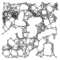
with networks in the real world. Hyperbolic geometric graph Spatial network analysis software Cascading failure Complex network Planar graphs Percolation...
10 KB (1,111 words) - 06:01, 12 April 2025
formats and mapping capabilities. The software is able to plot latitude and longitude coordinates and connect to spatial files like Esri Shapefiles, KML, and...
21 KB (1,776 words) - 17:59, 7 May 2025

Geographic information system (redirect from Gis software)
These tools can come in the form of add-ins to existing wider-purpose software such as spreadsheets. GIS spatial analysis is a rapidly changing field, and...
103 KB (13,339 words) - 03:39, 19 June 2025
assignment problem Location-allocation Dijkstra's algorithm List of spatial analysis software Competitive facility location game Vertex k-center problem...
21 KB (3,149 words) - 02:24, 24 December 2024
Tropes Zoom (section Tropes text analysis)
Tropes Zoom was a desktop search engine and semantic analysis software from Acetic/Semantic-Knowledge. Originally written by Pierre Molette in 1994 in...
5 KB (436 words) - 00:05, 20 January 2024
R (programming language) (redirect from RGL (software package))
the fields of data mining, bioinformatics, data analysis, and data science. The core R language is extended by a large number of software packages, which...
69 KB (6,003 words) - 18:16, 16 June 2025
available as a consumer tool (see the list of SNA software). Social network analysis has its theoretical roots in the work of early sociologists such as Georg...
58 KB (6,294 words) - 00:08, 19 June 2025
Cornerstone OnDemand (category Software companies of the United States)
Cornerstone OnDemand, Inc. is a cloud-based development software provider and learning technology company. The company was publicly traded on the NASDAQ...
8 KB (520 words) - 16:27, 4 April 2025
type of analysis needed, different methods should be employed. Two different methods to create hotspots are STAC (spatial and temporal analysis of crime)...
27 KB (3,757 words) - 12:29, 24 May 2025

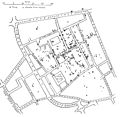
Geospatial topology (redirect from Spatial topology)
this is a feature of GIS software such as ArcGIS Pro and QGIS. Several spatial analysis tools are ultimately based on the discovery of topological relationships...
14 KB (1,620 words) - 23:46, 30 May 2024
Mass spectrometry software is used for data acquisition, analysis, or representation in mass spectrometry. In protein mass spectrometry, tandem mass spectrometry...
82 KB (3,996 words) - 22:38, 22 May 2025

Geomatics (redirect from Spatial science)
spatial database management and geographic information technology (GeoIT) Spatial analysis, spatial data mining and knowledge discovery, and spatial statistics...
17 KB (1,712 words) - 19:18, 14 April 2025

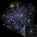
Network theory (redirect from Science of networks)
problem, routing problem, critical path analysis, and program evaluation and review technique. The analysis of electric power systems could be conducted...
35 KB (3,959 words) - 04:41, 15 June 2025

Space syntax is a set of theories and techniques for the analysis of spatial configurations. It was conceived by Bill Hillier, Julienne Hanson, and colleagues...
14 KB (1,834 words) - 23:29, 2 May 2025
Alignments of random points Almost surely Alpha beta filter Alternative hypothesis Analyse-it – software Analysis of categorical data Analysis of covariance...
87 KB (8,280 words) - 23:04, 12 March 2025
incorporating temporal and spatial visual attention with convolutional neural network and long short-term memory. Video analysis software is also being paired...
17 KB (1,449 words) - 00:02, 24 May 2025
Geodatabase (Esri) (category Spatial database management systems)
format developed in the late 1990s by Esri (a GIS software vendor) to represent, store, and organize spatial datasets within a geographic information system...
31 KB (3,473 words) - 01:38, 24 May 2025

Semantic network (section Software tools)
networks. There are also elaborate types of semantic networks connected with corresponding sets of software tools used for lexical knowledge engineering...
22 KB (2,561 words) - 18:20, 13 June 2025
Particle image velocimetry (category CS1 maint: multiple names: authors list)
systems had limited spatial resolution and were labor-intensive, but they provided valuable insights into fluid flow behavior. The advent of lasers in the 1960s...
53 KB (7,418 words) - 08:17, 29 November 2024