
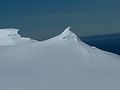
Miziya Peak (Bulgarian: връх Мизия, romanized: vrah Miziya, IPA: [ˈvrɤx ˈmizijɐ]) is the 604 m summit of Vidin Heights on Varna Peninsula, eastern Livingston...
4 KB (399 words) - 18:26, 15 September 2023
Mizia (town) (redirect from Miziya)
old name and village status. Miziya Peak on Livingston Island in the South Shetland Islands, Antarctica is named after Miziya. (in English) Bulgarian National...
1 KB (128 words) - 17:00, 24 August 2022
11 km northeast of Miziya Peak, 930 m north of Dospat Peak, 380 m southwest of Passy Peak and 1.73 km west-northwest of Madara Peak (Bulgarian mapping...
2 KB (221 words) - 22:49, 23 March 2020
1993–96. The peak is located at 62°31′43″S 60°08′27″W / 62.52861°S 60.14083°W / -62.52861; -60.14083, which is 1.4 km northeast of Miziya Peak, 8.6 km south...
2 KB (248 words) - 03:12, 1 November 2023
which is 1.28 km southeast of Miziya Peak, 4.2 km northeast of Leslie Hill and 6.58 km north of Melnik Peak. The peak was first mapped in the Bulgarian...
3 KB (212 words) - 12:44, 2 May 2023
east of Helis Nunatak, 3.73 km northeast of Samuel Peak and 5.08 km east-northeast of Miziya Peak (British survey in 1957-59 and mapping in 1968, Spanish...
2 KB (215 words) - 05:05, 30 June 2017
Leslie Hill, 1.9 km east-southeast of Miziya Peak, 5.7 km west of Edinburgh Hill and 6.76 km north by east of Melnik Peak. (British mapping in 1968, Bulgarian...
2 KB (209 words) - 12:25, 2 May 2023

05 km southeast by south of Castra Martis Hill, and 7.4 km south of Miziya Peak (Bulgarian topographic survey Tangra 2004/05, and mapping in 2005 and...
3 KB (346 words) - 18:26, 15 September 2023
10000, which is 1.58 km west of Sharp Peak, 3.6 km northeast of Miziya Peak and 1.38 km north-northeast of Madara Peak (Bulgarian topographic survey Tangra...
2 KB (218 words) - 13:10, 2 July 2019
Edinburgh Hill. The heights feature also Samuel Peak 1.9 m (6.2 ft) east-southeast of Miziya Peak, and Sharp Peak at their east-northeast extremity. The heights...
6 KB (491 words) - 04:18, 18 December 2023
Bulgaria. The peak is located at 62°32′23″S 60°08′45″W / 62.53972°S 60.14583°W / -62.53972; -60.14583 which is 1 km east-southeast of Miziya Peak, 930 m south...
2 KB (244 words) - 12:43, 2 May 2023
Point and 3 km southwest of Kotis Point and 4.9 km west-southwest of Miziya Peak. The feature was named after the settlement of Bezmer in Southeastern...
2 KB (210 words) - 07:00, 8 July 2019
26 km northeast of Samuel Peak, 1.25 km north-northwest of Sakar Peak, 1.3 km northeast of Samuel Peak, 2.6 km east of Miziya Peak, 1.4 km south-southwest...
2 KB (271 words) - 12:26, 2 May 2023
which is 5.17 km southeast of Williams Point, 7.61 km northeast of Miziya Peak in Vidin Heights, 5.49 km northwest of Inott Point, 4.36 km south-southwest...
3 KB (299 words) - 09:43, 11 July 2019

survey. The peak is located at 62°32′36.4″S 60°10′37″W / 62.543444°S 60.17694°W / -62.543444; -60.17694 which is 1.08 km southwest of Miziya Peak, 2.42 km...
4 KB (381 words) - 17:19, 15 September 2023

Mountains Great Needle Peak from Kuzman Knoll, with Helmet Peak in the left background Great Needle Peak from Miziya Peak, with Sliven Peak and Atanasov Nunatak...
11 KB (1,094 words) - 04:33, 26 March 2024
45222°S 60.13639°W / -62.45222; -60.13639 which is 9.47 km north of Miziya Peak in Vidin Heights, 8.8 km east of Desolation Island, 1.5 km south of Zed...
4 KB (469 words) - 04:49, 12 December 2018

Yavorov Peak (Bulgarian: Яворов връх, romanized: Yavorov vrah, IPA: [ˈjavorov ˈvrɤx]) is an ice-covered peak of elevation 640 m in the Delchev Ridge of...
3 KB (327 words) - 11:27, 15 September 2023
Paisiy Peak (Bulgarian: връх Паисий, romanized: vrah Paisiy, IPA: [ˈvrɤx pɐˈisij]) rises to approximately 550 m in the Delchev Ridge, Tangra Mountains...
2 KB (267 words) - 09:50, 1 December 2022

6.1 m (20 ft) north of Omurtag Pass and 1.29 m (4.2 ft) southwest of Miziya Peak (British mapping in 1968, rough Argentine mapping in 1980, and Bulgarian...
5 KB (352 words) - 04:22, 18 December 2023
Elena Peak (Bulgarian: връх Елена, romanized: vrah Elena, IPA: [ˈvrɤx ɛˈlɛnɐ]) is a 700 m peak in Delchev Ridge, Tangra Mountains on Livingston Island...
4 KB (447 words) - 22:45, 20 February 2024
Islands, Antarctica and bounded by Rayna Knyaginya Peak in Bowles Ridge to the southeast and by Hemus Peak to the northwest. The pass separates the glacial...
4 KB (449 words) - 18:12, 2 May 2023
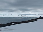
Esperanto Island Zed Islands from Miziya Peak; Esperanto Island is the leftmost one in the background Location of Esperanto Island Esperanto Island Geography...
4 KB (250 words) - 14:13, 23 June 2023
Antarctica. They are separated from Leslie Hill by Elhovo Gap, and from Hemus Peak off the northwest extremity of Bowles Ridge by Gurev Gap. The feature is...
3 KB (417 words) - 12:56, 15 September 2023
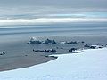
Bruix Cove (in the background) from Miziya Peak, surmounted by Delchev Peak and Ruse Peak....
2 KB (257 words) - 07:51, 12 July 2019
'kas-tra 'mar-tis\) is a 453 m hill near Leslie Hill in Livingston Island. The peak was named after the Roman settlement of Castra Martis, ancestor of the present...
2 KB (241 words) - 12:48, 2 May 2023
of elevation 450 m extending 3 km in south-north direction between Hemus Peak and Gleaner Heights in eastern Livingston Island in the South Shetland Islands...
4 KB (420 words) - 11:48, 17 March 2023
-60.01694 which is 13.15 km northwest of Renier Point, 7.52 km east of Miziya Peak, 2 km south-southwest of Inott Point, and 7 km southwest of Yovkov Point...
2 KB (230 words) - 12:28, 2 May 2023

summit of Gleaner Heights and 3.15 km (1.96 mi) south-southwest of Radnevo Peak. The hill was named by the UK Antarctic Place-Names Committee in 1958 for...
4 KB (304 words) - 04:26, 18 December 2023
Rakovski Nunatak, 2.2 km north of Zhelyava Hill, 7.18 km north by east of Miziya Peak and 4.9 km northeast of Kotis Point (British mapping in 1968, Spanish...
2 KB (309 words) - 22:51, 23 March 2020