
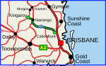
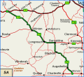
Wide Bay Highway is a short state highway of Queensland, Australia running between Goomeri on the Burnett Highway and a junction on the Bruce Highway...
8 KB (647 words) - 00:30, 21 January 2024

continues east of Goomeri as the Wide Bay Highway, connecting it to Gympie. In 2008, the intersection with Burnett Highway was reconstructed to favour Murgon-bound...
8 KB (448 words) - 02:42, 15 January 2024

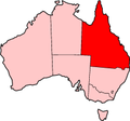
25°25′0″S 152°42′0″E / 25.41667°S 152.70000°E / -25.41667; 152.70000 Wide Bay–Burnett is a region of the Australian state of Queensland, located between...
14 KB (1,320 words) - 05:17, 8 December 2023

"Bruce Highway—Gentle Annie Road to St Arnauds Creek". Queensland Government. 15 July 2022. Retrieved 3 September 2022. "Bruce Highway—Wide Bay Highway intersection...
101 KB (5,398 words) - 13:50, 10 May 2024

Bunya, Wide Bay, Isis, Dawson and Leichhardt Highways, the following state-controlled roads, from south to north, intersect with the Burnett Highway: Kingaroy–Barkers...
15 KB (930 words) - 06:03, 27 April 2024
Captain Cook Highway Carnarvon Highway Balonne Highway Bunya Highway Moonie Highway Wide Bay Highway Gillies Highway Isis Highway Carnarvon Highway Castlereagh...
5 KB (381 words) - 10:22, 16 March 2024
Tin Can Bay Road Gympie–Woolooga Road Gympie Connection Road The following state-controlled roads intersect with section 10B: Wide Bay Highway Miva Road...
40 KB (3,348 words) - 15:45, 4 April 2024
The D'Aguilar Highway is a two-lane highway linking the Bruce Highway near Caboolture with the Bunya Highway in Kingaroy in the state of Queensland, Australia...
22 KB (1,114 words) - 05:42, 20 January 2024

Highway (State Route 70) Capricorn Highway (A4) Burnett Highway (A3) Dawson Highway (State Route 60) Isis Highway (State Route 52) Wide Bay Highway (State...
9 KB (592 words) - 04:05, 16 May 2024

Bunya and Wide Bay Highways, 255 kilometres (158 mi) from the state capital, Brisbane. The main street is Moore Street; the Burnett Highway follows Moore...
24 KB (1,987 words) - 15:17, 9 January 2024
Orillia), Highway 11 forms part of the Trans-Canada Highway and is part of MOM's Way between Thunder Bay and Rainy River. The original section of Highway 11...
131 KB (9,529 words) - 18:49, 4 June 2024

Highway 1 along either coast. Roads that make up the highway are: Great Central Road Gunbarrel Highway Lasseter Highway Stuart Highway Plenty Highway...
9 KB (315 words) - 05:03, 11 February 2024

Trans-Canada Highway, some of which have their driveways directly onto the highway. Highway 11/Highway 17 proceeds southeast for 65 km (40 mi) to Thunder Bay, then...
63 KB (7,875 words) - 07:31, 2 June 2024
King's Highway 17, more commonly known as Highway 17, is a provincially maintained highway and the primary route of the Trans-Canada Highway through the...
89 KB (6,792 words) - 21:13, 16 January 2024
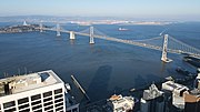
The San Francisco–Oakland Bay Bridge, known locally as the Bay Bridge, is a complex of bridges spanning San Francisco Bay in California. As part of Interstate...
120 KB (13,143 words) - 20:37, 28 May 2024

bridges on the Oregon Coast Highway designed by him. It superseded the last ferry crossing on the highway. Work on the Yaquina Bay Bridge began on August 1...
7 KB (658 words) - 07:43, 12 April 2024

continues further north with the Dalton Highway in Alaska. With this route, the Pan-American Highway begins in Prudhoe Bay, Alaska near Deadhorse. Traveling...
70 KB (8,694 words) - 11:06, 3 June 2024
well known by their official names. In addition to the Bruce Highway, the Peak Downs Highway, and the Mackay Ring Road, the network consists of the following...
8 KB (686 words) - 01:49, 10 February 2024
Bay is the town of Kāneʻohe. The Bay is approximately 8 mi (13 km) long and 2.7 mi (4.3 km) wide, with a mouth opening of about 4.6 mi (7.4 km) wide and...
6 KB (470 words) - 09:04, 2 November 2022
Landsborough Highway is a highway in western Queensland, Australia, running in the northwest–southeast direction from Morven to Cloncurry. The Landsborough...
10 KB (542 words) - 11:07, 27 July 2023

The Moonie Highway is a state highway of Queensland, Australia. Part of State Route 49, it leaves the Warrego Highway at Dalby and runs for over 290 km...
7 KB (549 words) - 10:25, 20 December 2023

Eyre Highway is a 1,664-kilometre (1,034 mi) highway linking Western Australia and South Australia via the Nullarbor Plain. Signed as National Highways 1...
51 KB (4,855 words) - 20:15, 31 May 2024

Birdsville Track (category Highways in Australia)
Queensland portal South Australia portal Highways in Australia List of highways in Queensland List of highways in South Australia Google (30 May 2022)...
10 KB (862 words) - 10:23, 13 October 2023
as a highway, but without a highway name. For example, Great Southern Highway is classified as a main road, not as a highway, or Hereward Highway in the...
24 KB (397 words) - 08:34, 6 June 2024
New England Highway state-controlled roads in Queensland presents information about how the Queensland segment of the New England Highway is described...
12 KB (1,052 words) - 01:05, 22 January 2024

The Balonne Highway, a state highway of Queensland, is the continuation westward of State Route 49 (Moonie Highway) from the town of St George to its termination...
7 KB (344 words) - 10:44, 20 December 2023

The Barkly Highway is a national highway in Queensland and the Northern Territory in Australia. It is the only sealed road between Queensland and the...
13 KB (834 words) - 05:26, 21 May 2024
Warrego Highway state-controlled roads presents information about how the Warrego Highway is described for administrative and funding purposes by the...
23 KB (1,932 words) - 00:40, 22 January 2024

endpoint of the highway. The entire highway is part of the National Highway system linking Darwin and Brisbane: formerly National Highway 54, Queensland...
30 KB (2,105 words) - 12:42, 9 March 2024
well known by their official names. In addition to the Bruce Highway and the Dawson Highway, the network consists of the following state-controlled roads:...
3 KB (267 words) - 00:03, 5 March 2024