
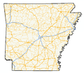
Highway 301 (AR 301, Ark. 301 and Hwy. 301) is a north–south state highway in Pike County, Arkansas. The route of 22.90 miles (36.85 km) runs from Highway 26/Highway 27...
5 KB (364 words) - 16:36, 16 February 2024
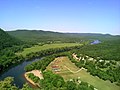
unincorporated community in Pike County, Arkansas, United States. Billstown is located on Arkansas Highway 301 near the Little Missouri River. First settled...
6 KB (378 words) - 17:43, 22 April 2024
of state highways in the U.S. state of Arkansas. The state does not use a numbering convention. Generally, the two-digit odd numbered highways run north–south...
244 KB (1,754 words) - 02:30, 7 April 2024
N301 highway (Philippines) U.S. Route 301 (former) U.S. Route 301 Arkansas Highway 301 Georgia State Route 301 Indiana State Road 301 Iowa Highway 301 (former)...
3 KB (221 words) - 22:58, 4 April 2024

Arkansas Highway 29 is a state highway that extends 77.2 miles (124.2 km) in South Arkansas. It runs north from the Louisiana state line to its terminus...
9 KB (471 words) - 16:29, 16 February 2024

U.S. Route 278 (redirect from U.S. Highway 278 (Arkansas))
universities located along the highway including Georgia State University, the University of Mississippi, and the University of Arkansas at Monticello. US 278...
22 KB (2,529 words) - 04:23, 15 June 2024

Donaldson is a town in Hot Spring County, Arkansas, United States. The population was 301 at the 2010 census. Donaldson is located in southern Hot Spring...
7 KB (614 words) - 18:48, 3 May 2024

Interstate 30 (redirect from Interstate 30 (Arkansas))
Interstate 30 (I-30) is a major Interstate Highway in the southern states of Texas and Arkansas in the United States. I-30 travels 366.76 miles from I-20...
52 KB (2,380 words) - 23:40, 14 June 2024

U.S. Route 78 (redirect from U.S. Route 78 in Arkansas)
(US 78) is an east–west United States Numbered Highway that runs for 843.3 miles (1,357.2 km) from Cash, Arkansas to Charleston, South Carolina. From Byhalia...
23 KB (2,039 words) - 00:55, 23 April 2024

Arkansas Highway 195 (AR 195, Ark. 195, and Hwy. 195) is the designation for a state highway in the U.S. state of Arkansas. The route is split into three...
7 KB (420 words) - 16:33, 10 June 2022

U.S. Route 70 (redirect from Arkansas Highway 70)
Atlas (Map). Rand McNally. 2014. p. 82–83. Arkansas State Highway Map (Map) (2007 ed.). Arkansas State Highway and Transportation Department. The 2014 Road...
46 KB (5,177 words) - 21:55, 6 January 2024

U.S. Highway 412 (US 412) runs east-to-west through northern Arkansas for about 290 miles (470 km). The route begins at the Oklahoma state line near Siloam...
24 KB (946 words) - 23:28, 21 April 2024

through truss bridge carrying Arkansas Highway 7 and Arkansas Highway 51 across the Ouachita River at Arkadelphia, Arkansas. The trusses of the bridge were...
3 KB (236 words) - 23:20, 4 August 2022

U.S. Route 82 (redirect from U.S. Highway 82 (Arkansas))
east–west United States highway in the Southern United States. Created on July 1, 1931 across central Mississippi and southern Arkansas, US 82 eventually became...
23 KB (2,187 words) - 17:56, 24 March 2024

Arkansas Highway 27 (AR 27, Ark. 27, and Hwy. 27) is a designation for two north–south state highways in Arkansas. One route begins at US Highway 59 (US 59)...
17 KB (815 words) - 16:29, 16 February 2024

Highway 300 (AR 300, Ark. 300 and Hwy. 300) is a designation for two state highway segments in Central Arkansas. The main route of 34.11 miles (54.89 km)...
9 KB (663 words) - 15:47, 8 June 2024

Highway 26 (AR 26, Ark. 26 and Hwy. 26) is the designation for a state Highway in the U.S. state of Arkansas. The highway is mainly located in Southwest...
9 KB (519 words) - 04:55, 8 September 2023

2012. General Highway Map, White County, Arkansas (PDF) (Map). 1:62500. Cartography by Planning and Research Division. Arkansas State Highway and Transportation...
37 KB (3,435 words) - 17:55, 6 May 2024

U.S. Route 64 (redirect from United States Highway 64)
Rocky Mount US 301 in Rocky Mount US 258 in Tarboro. The highways travel concurrently to Princeville. US 13 north of Bethel. The highways travel concurrently...
32 KB (2,917 words) - 15:28, 28 May 2024

S. Highway 62 U.S. Highway 71 U.S. Highway 412 Highway 12 Highway 16 Highway 43 Highway 59 Highway 72 Highway 94 Highway 102 Highway 112 Highway 127...
33 KB (2,104 words) - 20:04, 16 June 2024
access to two concurrent United States highways: U.S. Highway 62 (US 62) and US 412, and thirteen Arkansas state highways. Baxter County is served by two public...
61 KB (5,534 words) - 03:22, 10 June 2024

Highway 302 (AR 302, Ark. 302, and Hwy. 302) is a designation for three east–west state highways in the Arkansas Grand Prairie. All three are low traffic...
12 KB (926 words) - 16:36, 16 February 2024

miles (301 km2) is land and 0.6 square miles (1.6 km2) (0.52%) is water. Little Rock is on the south bank of the Arkansas River in Central Arkansas. Fourche...
66 KB (6,367 words) - 14:45, 30 May 2024
business district, ending at AR 8. The route was created by the Arkansas State Highway Commission (ASHC) on August 2, 1962, following construction of a...
61 KB (4,600 words) - 21:57, 8 May 2024

Arkansas Highway 19 (AR 19 and Hwy. 19) is a designation for two state highway in South Arkansas. The first route of 18.05 miles (29.05 km) runs from Louisiana...
12 KB (840 words) - 16:31, 16 February 2024

U.S. Route 66 (redirect from United States Highway 66 -- Historic)
U.S. Route 66 or U.S. Highway 66 (US 66 or Route 66) was one of the original highways in the United States Numbered Highway System. It was established...
85 KB (8,875 words) - 04:43, 11 June 2024

Sterling Highway, marker at Anchor Point, the westernmost point on the North American contiguous highway system. I-30; Marker is at the Arkansas Welcome...
46 KB (3,280 words) - 01:03, 5 June 2024

U.S. Route 50 in Colorado (redirect from U.S. Highway 50 (Colorado))
connects the Western Slope with the lower Front Range and the Arkansas Valley. The highway serves the areas of Pueblo and Grand Junction as well as many...
26 KB (1,622 words) - 17:36, 15 February 2024

Interstate 29 (redirect from Interstate 29 in Arkansas)
Interstate 29 (I-29) is an Interstate Highway in the Midwestern United States. I-29 runs from Kansas City, Missouri, at a junction with I-35 and I-70...
18 KB (1,725 words) - 16:25, 17 May 2024

United States Numbered Highway System is a route that branches off a U.S. Highway in order to divert traffic from the main highway. Special routes are distinguished...
253 KB (15,220 words) - 21:34, 10 June 2024