
The Cassini Map or Academy's Map is the first topographic and geometric map made of the Kingdom of France as a whole. It was compiled by the Cassini family...
6 KB (779 words) - 06:30, 20 May 2025

later named the Cassini Division. Cassini was also the first of his family to begin work on the project of creating a topographic map of France. In addition...
24 KB (2,610 words) - 21:03, 26 February 2025

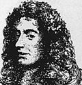
César-François Cassini de Thury (17 June 1714 – 4 September 1784), also called Cassini III or Cassini de Thury, was a French astronomer and cartographer. Cassini de...
7 KB (552 words) - 09:34, 6 December 2024

Cartography of the United States (redirect from Map of florida)
United States is the history of surveying and creation of maps of the United States. Maps of the New World had been produced since the 16th century....
2 KB (201 words) - 19:12, 20 May 2025
Cartography of France (redirect from Map of Cassini)
were made. The "map of Cassini" or "map of the Academy" is the first general map of the kingdom of France. It was drawn up by the Cassini family—primarily...
13 KB (1,566 words) - 00:53, 19 November 2023
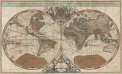
world maps date to classical antiquity, the oldest examples of the 6th to 5th centuries BCE still based on the flat Earth paradigm. World maps assuming...
73 KB (8,596 words) - 22:27, 18 May 2025
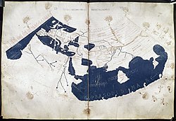
The Ptolemy world map is a map of the world known to Greco-Roman societies in the 2nd century. It is based on the description contained in Ptolemy's book...
7 KB (724 words) - 17:11, 27 January 2025

topological map is a type of diagram that has been simplified so that only vital information remains and unnecessary detail has been removed. These maps lack...
2 KB (133 words) - 23:02, 25 May 2025

Cassini–Huygens (/kəˈsiːni ˈhɔɪɡənz/ kə-SEE-nee HOY-gənz), commonly called Cassini, was a space-research mission by NASA, the European Space Agency (ESA)...
131 KB (12,225 words) - 12:20, 23 May 2025
The Cassini Grid was a grid coordinate system used on British military maps during the first half of the twentieth century, particularly during World...
7 KB (974 words) - 03:29, 21 June 2022
map) Maps of Russia Godunov map (1667) Maps of Scandinavia Carta marina (c. 1530) Det Kongelige danske Søkortarkiv (1784) French cartography: Cassini...
4 KB (372 words) - 23:00, 5 December 2022
Iapetus Cassini, South Australia Cassini oval, a mathematical curve described by Giovanni Cassini Cassini projection, in map making Cassini Glacier,...
1 KB (212 words) - 12:52, 16 December 2024

as generic for topographic surveys and maps. The earliest scientific surveys in France were the Cassini maps after the family who produced them over...
17 KB (1,988 words) - 19:00, 7 May 2025

Cartography (redirect from Map making)
chartēs, 'papyrus, sheet of paper, map'; and γράφειν graphein, 'write') is the study and practice of making and using maps. Combining science, aesthetics...
65 KB (7,642 words) - 16:26, 14 May 2025

Beaufour-Druval (category Pages using infobox settlement with image map1 but not image map)
French). Beaufou and Druval on the 1750 Cassini Map Beaufou and Druval on the 1790 Cassini Map Des villages de Cassini aux communes d'aujourd'hui: Commune...
8 KB (576 words) - 09:48, 9 January 2025

increasing latitude. Cesar-François Cassini de Thury completed the Cassini map, which was published by his son Cassini IV in 1790. Moreover, the Paris meridian...
33 KB (3,940 words) - 04:35, 27 January 2025

Rings of Saturn (redirect from Cassini Division)
suggested they formed early in the Solar System's existence, newer data from Cassini suggests a more recent date of formation. In September 2023, astronomers...
132 KB (13,395 words) - 14:47, 24 May 2025

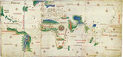
The map of Juan de la Cosa is a world map that includes the earliest known representation of the New World and the first depiction of the equator and...
10 KB (1,187 words) - 11:36, 24 May 2025

Bauquay (category Pages using infobox settlement with image map1 but not image map)
BnF 36174448w p. 59 (in French) Beaugnay on the 1750 Cassini Map Beaugnay on the 1790 Cassini Map List of Mayors of France (in French) Reelection 2014:...
7 KB (469 words) - 11:40, 20 January 2025

Bayonne (category Pages using infobox settlement with image map1 but not image map)
Basque-French Dictionary by Pierre Lhande, 1926. Cassini 1750: 1750 Cassini Map Cassini 1790: 1790 Cassini Map Origins: Chapter: Titles of the Chapter of Bayonne...
119 KB (13,097 words) - 10:26, 2 May 2025
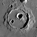
irregular outer rampart. Cassini is a crater of Lower (Early) Imbrian age. For unknown reasons, this crater was omitted from early maps of the Moon. This crater...
7 KB (523 words) - 14:13, 23 May 2024

The Cassini projection (also sometimes known as the Cassini–Soldner projection or Soldner projection) is a map projection first described in an approximate...
5 KB (771 words) - 00:03, 1 September 2024

Barbeville (category Pages using infobox settlement with image map1 but not image map)
December 2024. INSEE commune file Barbeville on the 1750 Cassini Map Barbeville on the 1790 Cassini Map List of Mayors of France (in French) Le nom des habitants...
6 KB (480 words) - 09:33, 9 January 2025
Cantino planisphere (redirect from Cantino World Map)
The Cantino planisphere or Cantino world map is a manuscript Portuguese world map preserved at the Biblioteca Estense in Modena, Italy. It is named after...
18 KB (2,415 words) - 14:31, 24 May 2025

Châteauneuf-du-Pape (category Pages using infobox settlement with image map1 but not image map)
1972, p. 74. Portes 1993, pp. 269–277. "France 1750, Cassini map". David Rumsey Historical Map Collection. Retrieved 9 February 2021.. Base Mérimée:...
39 KB (4,976 words) - 09:37, 25 April 2025
son, Cassini de Thury or Cassini III, to create a new French map. This map was known as the Carte de Cassini, and was to be a very accurate map of France...
7 KB (799 words) - 14:45, 24 May 2025

Barneville-la-Bertran (category Pages using infobox settlement with image map1 but not image map)
Barneville-la-Bertran appears as Barneville-la-Bertrand on the 1750 Cassini Map and as Barneville on the 1790 version. List of Successive Mayors The...
9 KB (614 words) - 13:25, 25 September 2024

Titan (moon) (section Cassini–Huygens)
light spectrum. The Cassini spacecraft used infrared instruments, radar altimetry and synthetic aperture radar (SAR) imaging to map portions of Titan during...
121 KB (11,888 words) - 18:24, 27 May 2025

Cartography of Africa (redirect from Map of africa)
Whereas most known early maps of Africa were prepared in the framework of the colonial enterprise, some indigenous maps have been recently uncovered, particularly...
4 KB (419 words) - 05:26, 5 August 2024

Catalan Atlas (category 14th-century maps)
(Catalan: Atles català, Eastern Catalan: [ˈatləs kətəˈla]) is a medieval world map, or mappa mundi, probably created in the late 1370s or the early 1380s (often...
38 KB (3,439 words) - 13:54, 25 May 2025