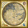
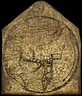
The Fra Mauro map is a map of the world made around 1450 by the Italian (Venetian) cartographer Fra Mauro, which is “considered the greatest memorial...
25 KB (3,464 words) - 09:40, 18 May 2025

He created the most detailed and accurate map of the world up until that time, the Fra Mauro map. Mauro was a monk of the Camaldolese Monastery of St...
9 KB (1,214 words) - 19:33, 6 May 2025
also collaborated with Fra Mauro on the Fra Mauro world map of 1459. Mainly a decoration piece, the Borgia map is a world map made sometime in the early...
73 KB (8,596 words) - 22:27, 18 May 2025
early 15th century. He was one of the sources used to create the 1450 Fra Mauro map, which indicated that there was a sea route from Europe around Africa...
16 KB (1,873 words) - 14:37, 12 April 2025
Fra Mauro may refer to: Fra Mauro (crater), a crater on the Moon Fra Mauro formation, landing site of Apollo 14, named after Fra Mauro crater Fra Mauro...
331 bytes (80 words) - 03:24, 6 July 2013
cartography, leading to the introduction of the Catalan Atlas and the Fra Mauro map. Marco Polo was born around 1254 in Venice, but the exact date and place...
103 KB (12,430 words) - 17:50, 17 May 2025

The Fra Mauro formation (or Fra Mauro Highlands) is a formation on the near side of Earth's Moon that served as the landing site for the American Apollo...
10 KB (1,172 words) - 09:34, 17 August 2024

Fra Mauro is the worn remnant of a walled lunar plain. It is part of the surrounding Fra Mauro formation, being located to the northeast of Mare Cognitum...
9 KB (643 words) - 03:45, 18 March 2025

Cape of Good Hope (category Articles containing OSM location maps)
died on the journey. In the 1450 Fra Mauro map, the Indian Ocean is depicted as connected to the Atlantic. Fra Mauro puts the following inscription by...
41 KB (4,681 words) - 08:41, 23 March 2025

story is not clear. The map later disappeared with its owners; a Jewish family from Heidelberg. Ancient world maps Fra Mauro map 1421 hypothesis De Smet...
6 KB (847 words) - 17:50, 26 March 2025


Apollo 14 (redirect from Statio fra mauro)
program. Shepard and Mitchell made their lunar landing on February 5 in the Fra Mauro formation – originally the target of Apollo 13. During the two walks on...
75 KB (9,089 words) - 14:06, 26 February 2025
Biancho in Venice, 1436." Andrea Bianco also collaborated with Fra Mauro on the Fra Mauro world map of 1459. The first page, or Tavola 1, shows a diagram of...
2 KB (298 words) - 17:48, 26 March 2025
world Fra Mauro map (1459), the territory of Novgorod-Moscow Rus' between Volga and White Sea is called White Russia (Rossia Biancha). This map gives...
14 KB (1,595 words) - 23:51, 21 March 2025
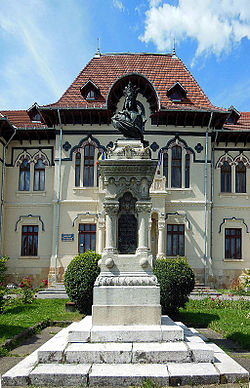
is a city in Argeș County, Muntenia, Romania. It is attested on the Fra Mauro map from 1450 as Campo longo. It is situated among the outlying hills of...
9 KB (938 words) - 22:19, 4 May 2025

Map, which cover the Indian Ocean including South India, Sri Lanka, the Maldives, and East Africa, suggests that the map is a composite of four maps,...
73 KB (9,144 words) - 02:16, 20 May 2025
Names of Japan (section Notation on old European maps)
the first time on a European map with the Fra Mauro map in 1457, although it appears much earlier on Chinese and Korean maps such as the Gangnido. Following...
44 KB (4,547 words) - 20:09, 4 May 2025

Here be dragons (section Dragons on maps)
there are even serpents so large that they could eat an ox whole.") The Fra Mauro Map (c. 1450) shows the "Island of Dragons" (Italian: Isola de' dragoni)...
10 KB (1,110 words) - 01:00, 27 December 2024

conspicuously omitted in the map of Gabriel de Vallseca (1439), the Genoese map (1457), the Fra Mauro map (1459) and the maps of Henricus Martellus Germanus...
40 KB (5,239 words) - 18:35, 2 February 2025
(1436) Fra Mauro map (c. 1450) Map of Bartolomeo Pareto (1455) Genoese map (1457) Map of Juan de la Cosa (1500) Cantino planisphere (1502) Piri Reis map (1513)...
4 KB (372 words) - 23:00, 5 December 2022

Good Hope found eggs of the roc, according to a caption in the 1456 Fra Mauro map of the world, which says that the roc "carries away an elephant or any...
16 KB (1,987 words) - 23:14, 11 May 2025
Edward Ullendorff has argued in support of this identification. In the Fra Mauro map of 1459, the Nile is called Gion, giving more credence to this claim...
4 KB (545 words) - 03:44, 31 March 2025

1430: Abu-l Fida Ishak, Muthir al Ghiram (The Exciter of Desire) 1459: Fra Mauro map 1470: Al-Suyuti: "Syria is divided into five provinces, or sections:—...
311 KB (37,119 words) - 21:34, 5 May 2025
Mappa mundi (category Map types)
massive map of Fra Mauro, may be seen as hybrids, incorporating Portolan-style coastlines into the frame of a traditional mappa mundi. Maps portal World...
15 KB (1,579 words) - 13:57, 9 February 2025

Cartography of Africa (redirect from Map of africa)
European exploration of Africa from the 15th century, maps of Africa became more precise. The Fra Mauro map of 1459 shows a more detailed picture of Africa...
4 KB (419 words) - 05:26, 5 August 2024

French historian of the early medieval forest, Charles Higounet, produced a map in the 1960s, which has been much reproduced since, that purports to show...
57 KB (6,294 words) - 14:00, 19 May 2025

Atlas (c. 1375), the Fra Mauro map (c. 1450), the Erdapfel (c. 1490, &Martin Waldseemüller's Carta marina (1516). A detail from "Map of the Holy Land with...
173 KB (16,364 words) - 10:34, 18 May 2025
during this time. Its name was first used in a European publication in Fra Mauro map made in Venice 1457-59, written as Lalabeda. A Portuguese priest, Francisco...
33 KB (3,357 words) - 09:07, 1 May 2025

more modern development than the Fra Mauro world map, with fairly good proportions given to each continents. The map also depicts a three-masted European...
3 KB (461 words) - 17:40, 26 March 2025

harder-to-interpret groups) are mentioned in the "Province of Russia" on the Venetian Fra Mauro Map (ca. 1450). Several documents mention the Meshchera concerning the Kazan...
24 KB (2,599 words) - 22:03, 29 March 2025