
The Map of Tendre (Carte de Tendre or Carte du Tendre) was a French map of an imaginary land called Tendre produced by several hands (including Catherine...
3 KB (361 words) - 01:53, 26 January 2024
Tendre can refer to: Map of Tendre, French map of fictional country Tendre Mont Tendre, mountain in Jura, Switzerland In musical directions, tenderly;...
226 bytes (60 words) - 05:51, 4 January 2016
Map of the Human Heart (also called Carte du Tendre and La Carte du Tendre; released in the Philippines as War Dragon) is a 1992 film by New Zealand director...
14 KB (1,554 words) - 01:55, 21 March 2024

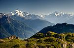
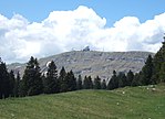
Mont Tendre is a mountain of the Jura, located between the valley of Joux and the basin of Lake Geneva in the canton of Vaud. With an elevation of 1,679...
2 KB (172 words) - 17:40, 16 April 2022

François Chauveau (category Members of the Académie royale de peinture et de sculpture)
illustrations for works by Mademoiselle de Scudéry (he engraved the famous Map of Tendre and the frontispiece for her Artamène), Scarron, Molière, Racine and...
4 KB (313 words) - 22:11, 6 January 2024
le blues" by Mad in Paris "Paris a le cœur tendre" by Georges Moustaki "Paris, a Night Piece - The Song of a Great City" by Frederick Delius "Paris à...
97 KB (14,156 words) - 23:55, 11 May 2024

description of Sapho in vol. 10 of Le Grand Cyrus the author paints herself. In Clélie, Scudéry invented the famous Carte de Tendre, a map of an Arcadia...
13 KB (1,450 words) - 02:05, 22 January 2024

Le Chasseron (category Mountains of the canton of Vaud)
topographic map. The key col is Col de Jougne (1,017 m). Retrieved from Google Earth. The nearest point of higher elevation is northeast of Mont Tendre. Media...
2 KB (88 words) - 01:27, 6 May 2022
director Alfred Hitchcock has a small cameo as a saloon bartender. Le Pied-tendre is a Lucky Luke comic written by Goscinny and illustrated by Morris. The...
98 KB (11,504 words) - 12:19, 4 April 2024

Matterhorn (redirect from List of references to the Matterhorn)
and Horn ("horn"), and is often translated as "the peak of the meadows". In the Schalbetter map, printed by Sebastian Münster in 1545, the valley is labelled...
101 KB (12,203 words) - 07:53, 30 April 2024

Map all coordinates using OpenStreetMap Download coordinates as: KML GPX (all coordinates) GPX (primary coordinates) GPX (secondary coordinates) The following...
13 KB (197 words) - 20:03, 1 April 2024
Map all coordinates using OpenStreetMap Download coordinates as: KML GPX (all coordinates) GPX (primary coordinates) GPX (secondary coordinates) This...
60 KB (466 words) - 18:50, 12 June 2024
original on April 11, 2013. Retrieved April 2, 2013. LeTendre, Brian (August 14, 2009). "The Gameplay of Batman: Arkham Asylum". Comic Book Resources. Boiling...
148 KB (12,121 words) - 12:42, 30 May 2024

Lyskamm (category Mountains of the Alps)
Alpine Journal, 5: 23–32 Alps portal List of Alpine four-thousanders Retrieved from the Swisstopo topographic maps. The key col is the Lisjoch (4,153 m)....
7 KB (744 words) - 07:42, 30 April 2024

Tödi (category Mountains of the canton of Glarus)
mountains of Switzerland List of most isolated mountains of Switzerland Retrieved from the Swisstopo topographic maps. The key col is the Oberalp Pass...
8 KB (991 words) - 08:24, 16 November 2022

Thuringia (redirect from Freestate of Thuringia)
blafarde, tendre sœur" for the Kunstfest art festival, Weimar, summer 1995 Herbert Kroemer (1928-2024), German-American physicist, co-laureate of the Nobel...
72 KB (7,272 words) - 06:18, 12 June 2024

glacier, now appears on the list with a prominence of 312 m. Map all coordinates using OpenStreetMap Download coordinates as: KML GPX (all coordinates)...
76 KB (1,275 words) - 09:36, 22 May 2024

Jura Mountains (redirect from Massif of Jura)
sub-alpine mountain range a short distance north of the Western Alps and mainly demarcate a long part of the French–Swiss border. While the Jura range proper...
16 KB (1,193 words) - 08:34, 17 May 2024

Breithorn (category Four-thousanders of Switzerland)
Jean-Jacques Erin. Alps portal List of mountains of the Alps over 4000 metres Retrieved from the Swisstopo topographic maps. The key col is the Schwarztor...
4 KB (328 words) - 08:08, 30 April 2024

Can of Worms Opened After Iconic Photographer Accused of Rape Commits Suicide". Haaretz. "Watch Tendres Cousines Online | Watch Full HD Tendres Cousines...
25 KB (2,202 words) - 11:38, 3 May 2024

P. G. T. Beauregard (category Members of the Aztec Club of 1847)
of Charleston, South Carolina, at the start of the Civil War at Fort Sumter on April 12, 1861. Three months later he helped win the First Battle of Bull...
84 KB (10,449 words) - 06:15, 24 May 2024

Chevalier de Saint-Georges (category Free people of color)
the music collection of the Bibliothèque Nationale, contains: Allegro: Loin du soleil, in E-flat. Andante: N'êtes vous plus la tendre amie? in F. Ariette:...
111 KB (13,246 words) - 17:25, 8 June 2024

Mönch (category Mountains of the canton of Bern)
(3 x 4.5 inches). Alps portal List of 4000 metre peaks of the Alps Retrieved from the Swisstopo topographic maps. The key col is the Unders Mönchsjoch...
4 KB (274 words) - 14:45, 10 January 2023

maps (1:25,000) VECTOR25 Primary surfaces (Swisstopo) [1] (areas with one decimal were retrieved from Google Earth) Topographical catchment areas of Swiss...
26 KB (248 words) - 17:58, 23 April 2024
La Dôle (category Mountains of the canton of Vaud)
peak in the Swiss portion of the Jura, after Mont Tendre. Administratively, the summit is split between the municipalities of Gingins, Chéserex and La...
8 KB (552 words) - 08:52, 5 May 2023

The Jura Mountains rise in Swiss territory to a height of 1,679 metres (5,509 ft) at Mont Tendre. Other high summits are La Dôle (1,677 metres (5,502 ft))...
65 KB (6,758 words) - 07:27, 2 June 2024

those of the Diablerets (most elevated), the Vanil Noir (most prominent) and Mont Tendre (most isolated). The first table lists the highest summits of the...
11 KB (338 words) - 13:01, 3 May 2024
Archived from the original on May 15, 2015. Retrieved May 25, 2015. LeTendre, Brian (April 24, 2009). "Paul Dini Talks Batman: Arkham Asylum". Comic...
233 KB (19,692 words) - 17:20, 12 June 2024

Jungfrau (category Mountains of the canton of Bern)
topographic maps. The key col is the Jungfraujoch (3,464 m) Retrieved from Google Earth. The nearest point of higher elevation is north of the Aletschhorn...
27 KB (3,714 words) - 08:09, 30 April 2024
list of ski areas, see List of ski areas and resorts in Switzerland. For a general list of mountains, see List of mountains of Switzerland. Map all coordinates...
14 KB (299 words) - 17:25, 15 March 2023