
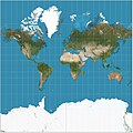
Nautical map Physical map Political map Relief map Resource map Road map Star map Street map Thematic map Topographic map Train track map Transit map Weather...
36 KB (4,374 words) - 12:48, 13 July 2025

example, colors can be used to indicate a classification of roads. These signs are usually explained in the margin of the map, or on a separately published...
20 KB (2,055 words) - 15:28, 25 May 2025
crowdsourced contributions to Google Maps were not discontinued as the company announced those features would be transferred to the Google Local Guides program...
164 KB (14,286 words) - 00:43, 17 July 2025
allowed cartographers to estimate the extent of their geographical knowledge, and to indicate parts of the planet known to exist but not yet explored as terra...
73 KB (8,596 words) - 00:42, 2 July 2025
HTTP 404 (redirect from 404 File Not Found)
standard response code, to indicate that the browser was able to communicate with a given server, but the server could not find what was requested. The...
16 KB (1,945 words) - 23:09, 3 June 2025
informational purposes and are of use to passengers for selection of their seat at booking or check-in. Seat maps usually indicate the basic seating layout; the...
7 KB (957 words) - 23:18, 16 April 2025

References today to the Fuller projection or Dymaxion usually indicate this version. Unlike other polyhedral map projections, the Dymaxion map does not use a gnomonic...
13 KB (1,367 words) - 00:51, 12 July 2025

An emergency position-indicating radiobeacon (EPIRB) is a type of emergency locator beacon for commercial and recreational boats; it is a portable, battery-powered...
86 KB (10,208 words) - 07:25, 3 July 2025
Mercator projection (redirect from Mercator map projection)
generally not believed to be based on any deliberate map projection, included windrose networks of criss-crossing lines which could be used to help set...
49 KB (6,858 words) - 10:56, 5 June 2025

such as Hungarian). Square brackets indicate a term that has not yet been confirmed. The table below indicates the types and, where known, numbers of...
137 KB (2,188 words) - 16:31, 12 July 2025
1964–1970 Since 1970 the map has used a reversed (red on white) British Rail "double arrow" beside the station name to indicate main line interchanges....
73 KB (6,157 words) - 12:37, 12 June 2025

The use of N to indicate "none" long survived in the historic apothecaries' system of measurement: used well into the 20th century to designate quantities...
75 KB (7,544 words) - 08:44, 4 July 2025
act of Congress, and expanded it to the west coast soon afterwards. At first, not all the data on the map was used due to a lack of time standardization...
25 KB (2,826 words) - 23:21, 16 April 2025
the formation of deep and long gullies. Inactive does not necessarily indicate the volcano will not erupt again. Mount Pinatubo had no recorded historical...
64 KB (341 words) - 09:08, 3 July 2025
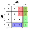
A Karnaugh map (KM or K-map) is a diagram that can be used to simplify a Boolean algebra expression. Maurice Karnaugh introduced the technique in 1953...
30 KB (3,588 words) - 17:11, 17 March 2025

Elevation (section Maps and GIS)
data for spatial analysis or cartography. A topographical map is the main type of map used to depict elevation, often through contour lines. In a Geographic...
6 KB (561 words) - 17:58, 4 May 2025

Pictorial maps (also known as illustrated maps, panoramic maps, perspective maps, bird's-eye view maps, and geopictorial maps) depict a given territory...
13 KB (1,595 words) - 19:44, 26 June 2025
iterations of this map lead to a dynamical system, further investigated by Marc Chamberland. He showed that the conjecture does not hold for positive real...
57 KB (7,098 words) - 19:54, 16 July 2025

Map, also known as the Madaba Mosaic Map, is part of a floor mosaic in the early Byzantine church of Saint George in Madaba, Jordan. The mosaic map depicts...
19 KB (2,084 words) - 12:54, 29 May 2025
Genetic linkage (redirect from Linkage map)
correspond one-to-one with the chromosomes.[citation needed] A linkage map is not a physical map (such as a radiation reduced hybrid map) or gene map.[citation...
31 KB (4,032 words) - 21:43, 15 July 2025

literally meaning "red-line". Japanese police drew a red line on maps to indicate the boundaries of legal red-light districts. In Japanese, the term...
9 KB (744 words) - 19:14, 13 May 2025

Kurdistan (category Articles to be expanded from March 2023)
boundaries they indicate have been readily accepted." At the end of the 1991 Gulf War, the Coalition established a no-fly zone over northern Iraq to provide humanitarian...
72 KB (7,502 words) - 19:15, 16 July 2025

relative to the axis of the Earth's orbit), in the top half. Maps are usually labelled to indicate which direction on the map corresponds to a direction...
14 KB (1,747 words) - 19:39, 13 May 2025

coastline for Asia distinct from the Americas, the Waldseemüller map apparently indicates the existence of a new ocean between the trans-Atlantic regions...
52 KB (7,165 words) - 16:45, 6 July 2025
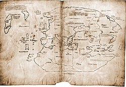
Map is a 20th-century forgery purporting to be a 15th-century mappa mundi with unique information about Norse exploration of North America. The map first...
40 KB (5,137 words) - 05:34, 10 June 2025

Surname maps are maps which display and indicate the highest concentration of residents with a particular surname, or set of surnames. This information...
1 KB (105 words) - 06:11, 21 December 2024
Wardley map, indicating that the service is closer to being a commodity. Other components are mapped similarly. For example, a drone operator needs to be aware...
14 KB (1,651 words) - 11:11, 29 March 2025
After Hours. The French term film noir translates literally to English as "black film", indicating sinister stories often presented in a shadowy cinematographic...
9 KB (988 words) - 07:29, 5 July 2025

Kievan Rus' (category Articles containing Ancient Greek (to 1453)-language text)
on loan to the British Museum for the BP exhibition Vikings: life and legend indicate the extent of Scandinavian settlement from the Baltic to the Black...
116 KB (12,623 words) - 19:54, 14 July 2025

world should sing a mass beneath it". Tolkien's map-notes for the illustrator Pauline Baynes indicate that the city had the latitude of Ravenna, an Italian...
53 KB (6,346 words) - 12:46, 8 July 2025