Route 1 is a highway in the Canada province of Newfoundland and Labrador, and is the easternmost stretch of the Trans-Canada Highway. Route 1 is the primary...
32 KB (1,175 words) - 00:58, 24 December 2024
This is a list of highways in Newfoundland and Labrador. Newfoundland and Labrador is unusual among jurisdictions in Canada in that it exclusively uses...
39 KB (2,795 words) - 03:06, 2 March 2024

primary entry point onto the island of Newfoundland and the western terminus of the Newfoundland and Labrador Route 1 (Trans-Canada Highway) in the province...
29 KB (2,050 words) - 09:52, 18 December 2024

The Trans-Labrador Highway (TLH) is the primary public road in Labrador, the mainland portion of the province of Newfoundland and Labrador, Canada. The...
25 KB (1,536 words) - 11:01, 17 February 2025

of Newfoundland and Labrador. Its eastern terminus is the intersection at the Trans-Canada Highway (Route 1) in the Town of Badger, and the route ends...
4 KB (312 words) - 01:44, 16 July 2024
Highway 1 Manitoba Highway 1 Newfoundland and Labrador Route 1 Prince Edward Island Route 1 Saskatchewan Highway 1 Other instances of Highway 1 New Brunswick...
19 KB (1,110 words) - 03:13, 9 May 2025
is a town on the Avalon Peninsula in Newfoundland and Labrador, Canada in Division 1. Whitbourne, Newfoundland's first inland town, is named after Sir...
8 KB (498 words) - 02:35, 28 January 2023
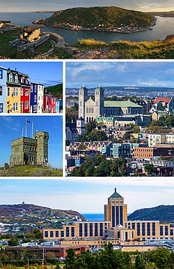
St. John's is the capital and largest city of the Canadian province of Newfoundland and Labrador. It is located on the eastern tip of the Avalon Peninsula...
160 KB (13,404 words) - 11:29, 29 April 2025

Route 201 (known as the Osprey Trail) is a provincial road in the Canadian province of Newfoundland and Labrador. It is one of only three loop roads designated...
4 KB (288 words) - 01:44, 16 July 2024

north–south highway on the western coast of Newfoundland in the Canadian province of Newfoundland and Labrador. It is one of two highways that connects the...
4 KB (260 words) - 15:46, 22 October 2022

Holyrood is a town on the Avalon Peninsula in Newfoundland and Labrador, Canada. It is in Division 1, on Conception Bay. It is approximately a 30-minute...
8 KB (384 words) - 02:29, 30 January 2023

town and designated place in the Canadian province of Newfoundland and Labrador. Located in the northeastern portion of the island of Newfoundland on Freshwater...
7 KB (427 words) - 19:33, 16 February 2025

province of Newfoundland and Labrador. The road provides a direct link from the Trans-Canada Highway (TCH) to downtown St. John's, Newfoundland, which was...
10 KB (653 words) - 22:11, 30 August 2024
local service district and designated place in the Canadian province of Newfoundland and Labrador on the island of Newfoundland. It is located on the southeastern...
12 KB (1,054 words) - 22:18, 27 February 2025
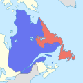
The border between the province of Newfoundland and Labrador and the province of Quebec is the longest interprovincial border in Canada. It stretches...
59 KB (6,527 words) - 20:26, 12 May 2025

Cove-St. Philips in Newfoundland and Labrador, Canada. Route 40 also serves as the primary access to St. John's International Airport and the Bell Island...
4 KB (271 words) - 21:09, 30 August 2024

Route 213 is a highway on the Burin Peninsula of the island of Newfoundland in the Canadian province of Newfoundland and Labrador. It is one of a small...
3 KB (189 words) - 15:10, 22 October 2022

of the island of Newfoundland. It connects the towns of Seal Cove and Hermitage-Sandyville with Route 360 (Bay d'Espoir Highway). Route 364 begins on the...
5 KB (270 words) - 14:19, 27 April 2024
Grand Falls-Windsor (redirect from Windsor, Newfoundland and Labrador)
located in the central region of the island of Newfoundland in the province of Newfoundland and Labrador, Canada, with a population of 13,853 at the 2021...
30 KB (2,605 words) - 05:21, 18 March 2025

Route 403 is a minor highway in the western region of Newfoundland in the Canadian province of Newfoundland and Labrador. The highway begins at a junction...
2 KB (134 words) - 01:45, 16 July 2024

highway on the Avalon Peninsula of Newfoundland. It runs between the town of Cupids and the city of St. John's. Route 60 begins as Topsail Road at the west...
8 KB (342 words) - 06:57, 16 January 2023

in the Canadian province of Newfoundland and Labrador. It connects the town of Burgeo with the Trans-Canada Highway (Route 1). The highway is a winding...
4 KB (286 words) - 16:35, 18 April 2023
Canadian province of Newfoundland and Labrador. St. Anthony serves as a main service centre for northern Newfoundland and southern Labrador. St. Anthony had...
23 KB (1,626 words) - 00:46, 15 April 2025

Route 406, also known as Codroy Road, is a highway on the western portion of Newfoundland in the Canadian province of Newfoundland and Labrador. It is...
4 KB (217 words) - 01:44, 16 July 2024

province of Newfoundland and Labrador. The route's southern terminus is the Trans-Canada Highway (Route 1) in the community of Tompkins, and its northern...
4 KB (228 words) - 01:45, 16 July 2024

Route 20 is a 30.2-kilometre-long (18.8 mi) provincial highway in Newfoundland and Labrador, extending from St. John's to the towns of Torbay, Flatrock...
6 KB (302 words) - 21:23, 31 January 2025
largest of the offshore islands of Newfoundland and Labrador, Canada. It lies off the northeast coast of Newfoundland, northwest of Musgrave Harbour across...
15 KB (1,669 words) - 13:39, 13 March 2025

the Canadian province of Newfoundland and Labrador. The highway begins at a junction with Route 1 (Trans-Canada Highway) and continues to its west terminus...
3 KB (186 words) - 15:42, 22 October 2022

Canadian province of Newfoundland and Labrador. The route begins at the intersection of Route 1 (The Trans Canada Highway) in Deer Lake and ends in St. Anthony...
14 KB (825 words) - 18:21, 5 April 2024

Route 30 is a 12.0-kilometre-long (7.5 mi) north-south provincial highway in Newfoundland and Labrador, extending from St. John's through Logy Bay-Middle...
3 KB (180 words) - 23:28, 14 February 2024