
following outline is provided as an overview of and topical guide to Cornwall: Cornwall – ceremonial county and unitary authority area of England within...
30 KB (2,594 words) - 22:46, 29 April 2024
Duke of Cornwall (Cornish: Duk a Gernow) is a title in the Peerage of England, traditionally held by the eldest son of the reigning British monarch, previously...
26 KB (1,820 words) - 21:39, 25 May 2024

Church of England Primary School. Christianity in Cornwall Index of Cornwall-related articles Outline of Cornwall – overview of the wide range of topics...
142 KB (13,468 words) - 10:36, 21 May 2024
Salem is a hamlet west of Chacewater, Cornwall, England. Cornwall portal Ordnance Survey One-inch Map of Great Britain; Truro and Falmouth, sheet 190...
826 bytes (28 words) - 18:10, 29 January 2024

the south coast of Cornwall, England, in the civil parish of St Austell Bay. It is situated approximately 2 miles (3 km) south east of St Austell town...
16 KB (1,924 words) - 16:13, 20 February 2024

of Towednack, Cornwall, England. Georgia is situated 3.5 miles (5.6 km) south-west from St Ives, Cornwall. Georgia lies within the Cornwall Area of Outstanding...
1 KB (59 words) - 10:23, 20 December 2020

Cape Cornwall (Cornish: Kilgoodh, meaning "goose back") is a small headland in West Cornwall, England. It is 4 miles (6.4 km) north of Land's End near...
5 KB (514 words) - 09:03, 16 April 2023

Cocks is a hamlet in the parish of Perranzabuloe in Cornwall, England. Cocks is southeast of Perranporth. Ordnance Survey: Landranger map sheet 200 Newquay...
1 KB (76 words) - 12:21, 27 September 2023
with a harbour on the south coast of Cornwall, England, United Kingdom. The village is situated in the civil parish of Tywardreath and Par, although West...
13 KB (1,726 words) - 11:32, 20 May 2024

court') in Cornwall is at the southern tip of the Lizard Peninsula. It is situated half-a-mile (800 m) south of Lizard village in the civil parish of Landewednack...
10 KB (897 words) - 09:27, 22 December 2022

civil parish and port in Cornwall, England, United Kingdom. The town lies north of Penzance and west of Camborne on the coast of the Celtic Sea. In former...
58 KB (6,481 words) - 18:52, 21 April 2024

in Cornwall, England, United Kingdom. It is opposite Padstow on the north-east bank of the River Camel estuary. The village is in the civil parish of St...
9 KB (784 words) - 19:23, 15 March 2024

North Cornwall (Cornish: An Tiredh Uhel) is an area of Cornwall, England, United Kingdom. It is also the name of a former local government district, which...
8 KB (596 words) - 11:59, 6 April 2024

Tintagel (redirect from Tintagel, Cornwall, England)
Mountain) is a civil parish and village situated on the Atlantic coast of Cornwall, England, United Kingdom. The village and nearby Tintagel Castle are...
46 KB (5,806 words) - 11:54, 3 May 2024
Coombe, Camborne (redirect from Coombe, Camborne, Cornwall)
a hamlet in west Cornwall, England, United Kingdom. It is situated two miles (3 km) north of the town of Camborne in the valley of the Red River at grid...
732 bytes (75 words) - 23:09, 1 November 2022

is a hamlet south of Kilkhampton in Cornwall, England. Hersham is near Grimscott. It is in the civil parish of Launcells. Cornwall portal Ordnance Survey:...
764 bytes (71 words) - 11:24, 27 October 2022

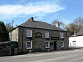
hamlet in the parish of Pelynt in southeast Cornwall, England, UK. Barcelona (grid reference SX 219 536) is a hamlet, in southeast Cornwall, on the A387 road...
3 KB (288 words) - 13:31, 17 May 2024

near St Eval in Cornwall, England. On the coast nearby is Pentire Steps. It should not be confused with Pentire, a western suburb of Newquay (grid ref...
1 KB (63 words) - 17:17, 7 April 2020

south-west Cornwall, England, UK. It is located within the civil parish of Constantine, 1 kilometre (0.62 mi) north-west of the village of the same name...
797 bytes (76 words) - 09:24, 26 April 2022
is a hamlet in the parish of Bude-Stratton, Cornwall, England, UK (where the 2011 census population is included). Cornwall portal Ordnance Survey: Landranger...
680 bytes (63 words) - 19:44, 24 April 2022
Penzance (redirect from Penzance, Cornwall)
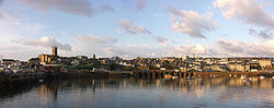
district of Cornwall, England, United Kingdom. It is the most westerly major town in Cornwall and is about 64 miles (103 km) west-southwest of Plymouth...
85 KB (10,985 words) - 16:23, 14 May 2024
Old Park is a hamlet in the parish of Liskeard, Cornwall, England, UK. Cornwall portal Ordnance Survey: Landranger map sheet 201 Plymouth & Launceston...
1 KB (41 words) - 18:07, 10 April 2020
Coldharbour is a hamlet in the parish of Perranzabuloe, Cornwall, England. Cornwall portal Ordnance Survey: Landranger map sheet 204 Truro & Falmouth...
1 KB (38 words) - 15:17, 24 March 2020

in the parish of St Ive and Pensilva in east Cornwall, England, UK. 50°29′24″N 4°23′13″W / 50.49°N 4.387°W / 50.49; -4.387 Cornwall portal Ordnance...
533 bytes (54 words) - 09:24, 23 April 2022
Hill is a hamlet in the parish of Chacewater (where the 2011 Census population was included), Cornwall, England. Cornwall portal Ordnance Survey: Landranger...
708 bytes (64 words) - 19:45, 24 April 2022
Roche parish, mid Cornwall, England, lying about 1+1⁄2 miles (2.4 km) northeast of Roche village at grid reference SX003614. Cornwall portal Ordnance Survey...
1,019 bytes (72 words) - 07:35, 27 September 2023

Northcott is a hamlet in Cornwall, England. Northcott is north of Bude and on the coast close to Northcott Mouth. Cornwall portal Ordnance Survey: Landranger...
787 bytes (69 words) - 04:24, 22 January 2023
Coombe, St Stephen-in-Brannel (redirect from Coombe, St. Austell, Cornwall)
Komm) is a village in mid Cornwall, England, United Kingdom. The village is situated approximately four miles (6 km) west of St Austell at grid reference...
1,005 bytes (79 words) - 21:28, 16 October 2023
Clubworthy (category Hamlets in Cornwall)
is a hamlet in east Cornwall, England, United Kingdom. It is located six miles (8.5 km) north-northwest of Launceston . Cornwall portal Ordnance Survey:...
559 bytes (59 words) - 09:16, 23 April 2022

Woodford lies within the Cornwall Area of Outstanding Natural Beauty (AONB). Cornwall portal Philip's Street Atlas Cornwall. London: Philip's, 2003; p...
1 KB (54 words) - 18:04, 12 July 2021