
Swisstopo is the official name for the Swiss Federal Office of Topography, Switzerland's national mapping agency. The current name was made official in...
17 KB (2,183 words) - 12:11, 5 February 2025

National Maps of Switzerland (redirect from Swisstopo maps)
Switzerland, also referred to as the Swisstopo maps, are a set of official map series designed, edited and distributed by Swisstopo, the Swiss Federal Office of...
4 KB (426 words) - 13:09, 24 February 2025
Liechtenstein for maps and surveying by the Swiss Federal Office of Topography (Swisstopo). A first coordinate system was introduced in 1903 under the name LV03...
7 KB (968 words) - 02:16, 21 January 2025

Map 1:25 000. Berne, Switzerland: Swiss Federal Office of Topography – swisstopo. 2012. ISBN 978-3-302-01208-7. Retrieved 2016-08-21. "Harder Kulm". Jungfrau...
3 KB (236 words) - 14:47, 4 May 2024

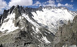
Titlis from Pilatus List of mountains of Switzerland Retrieved from the Swisstopo topographic maps [1] and Google Earth. The key col is the Susten Pass...
8 KB (810 words) - 10:50, 27 October 2024

the Hagenturm, a 40-metre-high observation tower. Retrieved from the swisstopo topographic maps. The key col is the Schwedenschanze (886 m). Map of cantons...
2 KB (96 words) - 17:21, 24 December 2022

"Search.ch" (Map). Schulhaus Hofern. Cartography by search.ch, TomTom, swisstopo, osm. Zurich, Switzerland: Tamedia AG. Retrieved 2015-04-23. "Zentrum...
17 KB (1,525 words) - 10:24, 2 May 2025

above the Morteratsch Glacier View from Diavolezza Retrieved from the Swisstopo topographic maps. The key col is the Maloja Pass (1,812 m). Retrieved...
12 KB (1,310 words) - 13:24, 26 October 2024

List of highest road passes in Switzerland Albula Pass, Swisstopo topographic maps Swisstopo maps, official maps of Switzerland by the Swiss government...
4 KB (340 words) - 02:55, 28 October 2024

border. On its northern side it overlooks the Otemma Glacier. On the Swisstopo map, Becca Rayette is the name of a 3,432 m sub-peak on the SW spur neighboring...
2 KB (106 words) - 19:59, 4 May 2022
is renamed as the Swiss Federal Office of Topography in 1979, with the swisstopo.ch website online since 1997. The first systematic geographical description...
15 KB (1,944 words) - 16:57, 19 July 2021

The Western Lyskamm (German: Liskamm Westgipfel) is a subsidiary peak of the Lyskamm. Swisstopo map v t e v t e...
1 KB (21 words) - 23:34, 5 April 2025

the exit in Geneva According to the Swiss Federal Office of Topography, Swisstopo, Lac de Genève designates that part of the Petit Lac which lies within...
40 KB (2,893 words) - 03:04, 25 May 2025

with the Schleitheimer Randenturm (896 m (2,940 ft)) in Switzerland. Swisstopo topographic maps Wikimedia Commons has media related to Randen. Randen...
2 KB (143 words) - 23:50, 1 November 2024

mountains of Switzerland accessible by public transport Retrieved from the Swisstopo topographic maps and Google Earth. The key col is located east of the...
4 KB (377 words) - 07:18, 26 October 2024

cantons of Fribourg and Bern. It lies south of Jaun. Retrieved from the Swisstopo topographic maps. The key col is Wolfs Ort (1,921 m). Rüdigenspitze on...
1 KB (48 words) - 17:42, 3 May 2022
valley of the Gauli Glacier from the main Aar valley. Retrieved from the Swisstopo topographic maps. The key col is the Ärlenlücke (3,059 m). Steinlauihorn...
1 KB (56 words) - 18:36, 2 May 2022

https://web.archive.org/web/20120607113752/http://www.swisstopo.admin.ch/internet/swisstopo/en/home/topics/knowledge/center_ch.html https://web.archive...
2 KB (203 words) - 07:31, 13 May 2024

transport Retrieved from the Swisstopo topographic maps. The key col is located at Ächerli (1,398 m). Retrieved from the Swisstopo topographic maps. Two intermediate...
8 KB (896 words) - 09:44, 18 November 2024

"Topographic map of Piz Bernina". opentopomap.org. Retrieved 3 July 2023. Swisstopo Wikimedia Commons has media related to Bernina. Visual day-by-day narrative...
7 KB (272 words) - 12:35, 9 April 2025

Switzerland List of mountains of Switzerland above 3000 m Retrieved from the Swisstopo topographic maps. The key col is the Nördliches Eigerjoch (3,605 m). Retrieved...
38 KB (4,857 words) - 17:45, 6 May 2025
Switzerland List of most isolated mountains of Switzerland Retrieved from the Swisstopo topographic maps. The key col is the Grimsel Pass (2,164 m). Retrieved...
3 KB (195 words) - 12:42, 21 April 2024

Switzerland named after people Tourism in Switzerland Retrieved from the Swisstopo topographic maps. The key col is the Glaubenberg Pass (1,543 m). Retrieved...
12 KB (811 words) - 17:53, 18 March 2025
swisstopo). Berne, Switzerland: Swiss Federal Office of Topography – swisstopo. 28 February 2016. Retrieved 2016-10-04. Retrieved from the Swisstopo topographic...
4 KB (384 words) - 12:01, 29 April 2024
from the Swisstopo topographic maps. The key col is located between Estavayer-le-Lac and Bussy at 480 metres. Retrieved from the Swisstopo topographic...
2 KB (126 words) - 17:53, 28 March 2023
It overlooks the Engstligenalp on its western side. Retrieved from the Swisstopo topographic maps. The key col is located south of the mountain at 2,600...
1 KB (56 words) - 18:25, 3 May 2022
separates the valley of Diemtigen from the Simmental. Retrieved from the Swisstopo topographic maps. The key col is located west of the Türmlihorn at 2,179...
1 KB (65 words) - 17:56, 16 April 2022

between the Rhone Glacier and the Damma Glacier. Retrieved from the Swisstopo topographic maps and Google Earth. The key col is the Dammajoch (3,570...
1 KB (61 words) - 16:13, 15 May 2022

Eggstock (2,436 m) and the Vorderer Eggstock (2,449 m). Retrieved from the Swisstopo topographic maps. The key col is located west of the summit at 2,359 metres...
2 KB (105 words) - 17:22, 16 April 2022
lying south of the Bocchetta da Vartegna (2,588 m). Retrieved from the Swisstopo topographic maps. The key col is the Bocchetta da Vartegna (2,588 m)....
2 KB (86 words) - 15:44, 4 May 2022