The World-Wide Navigational Warning Service (WWNWS) is a radio system set up by the International Hydrographic Organization (IHO) which provides hazard...
7 KB (732 words) - 15:03, 22 April 2025
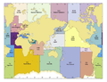
NAVAREA (category Navigation)
"Worldwide Navigational Warnings Service - Guidance Document" which is related to NAVAREAs. World-Wide Navigational Warning Service – Global radio warning system...
2 KB (175 words) - 07:15, 22 May 2024

location-indication navigational systems, outputting the location of the receiver as latitude and longitude. Hyperbolic systems were introduced during World War II...
40 KB (5,315 words) - 22:23, 16 January 2025
collision warning radar AN/APN-128 development of AN/APN-97 navigational radar by Teledyne for C-130 AN/APN-129 improved AN/APN-128 Doppler navigational radar...
120 KB (13,227 words) - 11:49, 10 May 2025

direct routing FMS-generated navigational information that used a different naming convention from that published in navigational charts The Civil Aeronautics's...
33 KB (3,310 words) - 01:12, 15 May 2025

display (HUD), navigational forward-looking IR system NAVFLIR and the Damocles targeting pod. The aircraft carries missile approach warning sensor (MAWS)...
18 KB (1,781 words) - 13:58, 9 March 2025
Beacon (redirect from Navigational beacon)
telegraphy. Beacons help guide navigators to their destinations. Types of navigational beacons include radar reflectors, radio beacons, sonic and visual signals...
22 KB (2,421 words) - 14:30, 27 April 2025
bridge personnel; Improved navigational safety by reducing the administrative workload; Improve confidence in the use of navigational equipment; Enhance the...
13 KB (1,714 words) - 20:14, 23 April 2025

began service in 1928. Radiobeacons are still in use today, although most have recently been decommissioned as improved electronic navigational aids have...
15 KB (1,519 words) - 17:09, 10 April 2025

developed for the Soviet Navy and currently in service in Russia, China, and India in the naval airborne early warning and control role. As with all Kamov helicopters...
13 KB (1,471 words) - 02:30, 22 November 2024

approach warning system (MAW) is part of the avionics package on some military aircraft. A sensor detects attacking missiles. Its automatic warning cues the...
24 KB (3,016 words) - 07:01, 19 March 2025
Hydrographic office (redirect from Hydrographic service)
the publication of nautical charts. In many countries, various navigation-related services are now concentrated in large governmental organizations, sometimes...
17 KB (2,147 words) - 20:59, 17 May 2025

Avionics (section Navigation)
greatly simplifying navigation. Modern weather systems also include wind shear and turbulence detection and terrain and traffic warning systems. In‑plane...
28 KB (3,288 words) - 19:08, 6 May 2025
Battle of the Beams (redirect from Knickebein (navigation))
the Second World War when bombers of the German Air Force (Luftwaffe) used a number of increasingly accurate systems of radio navigation for night bombing...
30 KB (4,306 words) - 22:20, 19 April 2025
Global Positioning System (redirect from Precise Positioning Service)
1960. It used a constellation of five satellites and could provide a navigational fix approximately once per hour. In 1967, the U.S. Navy developed the...
185 KB (19,124 words) - 16:20, 13 May 2025
radio navigational warning service, the collection and analysis of hydrographic and navigational information required for the official navigational charts...
19 KB (1,968 words) - 10:11, 31 March 2024

most widely used tank in the world and has seen service in over 50 countries. It has also served as the platform for a wide variety of specialty armoured...
194 KB (22,714 words) - 20:54, 16 May 2025

The Wide Area Augmentation System (WAAS) is an air navigation aid developed by the Federal Aviation Administration to augment the Global Positioning System...
42 KB (4,012 words) - 16:26, 17 March 2025

Instrument flight rules (section Navigation)
reference to the ground, a means of navigation other than looking outside the window is required. A number of navigational aids are available to pilots, including...
23 KB (2,773 words) - 14:30, 31 March 2025
Water safety (section Lifeboat service)
towing operations to assist mariners in distress and prevent navigational hazards. The World Health Organization has reported that drowning is the third...
10 KB (952 words) - 00:31, 2 September 2024
(VASI) – Visual flight rules (VFR) – VNE – VOR VHF omni-range (type of navigational beacon) – Visual meteorological conditions – Vortex generator War emergency...
16 KB (1,398 words) - 06:32, 26 April 2025

Aviation obstruction lighting (redirect from Aircraft warning lamps)
a distribution system which carries high voltages and wide-range AC current. The ideal warning light must be able to power itself while clamped to a single...
16 KB (1,977 words) - 15:48, 8 May 2025

2025 U.S.–Houthi ceasefire (category Pages using military navigation subgroups without wide style)
ending the March–May 2025 United States attacks in Yemen, as well as the wider US–UK airstrikes on Yemen since the beginning of the Red Sea crisis. The...
13 KB (1,153 words) - 20:57, 14 May 2025

South Carolina was put under a tropical storm warning, and Governor Henry McMaster issued a state-wide state of emergency declaration. Congaree National...
227 KB (19,014 words) - 16:50, 12 May 2025

New Cyrano IVM3 radar, SAGEM inertial navigation system, and head-up display. Equipped with a Sherloc radar warning receiver, and an ALE-40 chaff/flare...
40 KB (4,389 words) - 05:48, 17 May 2025
United States Armed Forces (redirect from United States Armed Services)
to support world-wide operations. Provide rapid global mobility to employ and sustain organic air and space forces and other military service and U. S....
220 KB (18,716 words) - 02:13, 15 May 2025
start in 1942 but service trials showed problems and deployment stopped. Replaced by the FuG 16. Completed units rebuilt as BS 15 navigation radio beacons...
34 KB (5,221 words) - 22:47, 17 January 2025
warning but no directional information. The BTL developed a 500-MHz (0.6-m) fire-control radar designated FA (later, Mark 1). A few went into service...
142 KB (22,260 words) - 00:21, 5 May 2025

Automobile Club (RSAC) erected their own, idiosyncratic warning boards and direction signs on a wide scale. Under the Motor Car Act 1903 four national signs...
107 KB (11,130 words) - 03:34, 29 April 2025

Nimitz-class aircraft carrier (section Service history)
nuclear-powered aircraft carriers in service with the United States Navy. The lead ship of the class is named after World War II United States Pacific Fleet...
78 KB (7,168 words) - 17:46, 4 May 2025