
Mount Atago is a very common name for peaks all over Japan. Mount Atago (愛宕山, Atago-yama/san) is a 924m mountain in the northwestern part of Ukyo-ku,...
2 KB (116 words) - 20:54, 18 October 2023

The Atagoyama Kofun (愛宕山古墳) is a kofun burial mound located in the Atago neighborhood of the city of Mito in Ibaraki Prefecture in the northern Kantō...
5 KB (395 words) - 14:47, 7 December 2023

The Atagoyama Kofun (愛宕山古墳) is a kofun burial mound located in the city of Gyōda, Saitama Prefecture, in the Kantō region of Japan. The tumulus was designated...
4 KB (291 words) - 14:50, 7 December 2023
Raikō (雷光 (らいこう) Voiced by Kenichi Ogata Harimanada's master. Atagoyama (愛宕山 (あたごやま) Voiced by Yuzuru Fujimoto The Chairman of the Sumo Association. He...
6 KB (472 words) - 09:41, 18 March 2023

721306 (The Kawaguchi Ferry and Zenkōji temple) 21 Mount Atago in Shiba (芝愛宕山, Shiba Atagoyama) Atago Shrine, Edo Bay Scene depicts an emissary from Enpuku-ji...
70 KB (884 words) - 19:09, 29 April 2024

Mount Atago (愛宕山, Atago-yama) is a mountain on the border of the cities of Minamibōsō and Kamogawa in Chiba Prefecture, Japan with an altitude of 408...
4 KB (352 words) - 11:40, 9 May 2024
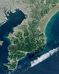
Mountain Japanese name Altitude Location Mount Atago 愛宕山 408.2 m (1,339 ft) Minamibōsō Mount Seichō 清澄山 377 m (1,237 ft) Kamogawa Mount Iyogatake 伊予ヶ岳...
6 KB (481 words) - 01:40, 24 August 2022

2019-02-05. "Keifuku Line (Randen)". Discover Kyoto. Retrieved 2010-10-11. "幻の鉄道「愛宕山鉄道」を訪ねて". www.geocities.jp. Archived from the original on 2018-12-27. Retrieved...
6 KB (386 words) - 11:40, 1 October 2021

2-chōme. As of April 1, 2008, it has a total population of 323. Mount Atago (愛宕山, Atago-yama) occupies most of the district. The lower zone located between...
2 KB (215 words) - 18:18, 8 October 2022

139.477083°E / 36.12278; 139.477083 (Okunoyama Kofun) Atagoyama Kofun (愛宕山古墳) 053 30 03,4 36°7′34″N 139°28′36.5″E / 36.12611°N 139.476806°E / 36...
7 KB (551 words) - 18:11, 30 October 2023
江若鉄道 Still active as Kōjaku Kōtsū 江若交通, a bus operator. Atagoyama Railway 愛宕山鉄道 Hokutan Railway 北丹鉄道 Kaya Railway 加悦鉄道 Still active as Kaya Kōsan カヤ興産...
39 KB (4,003 words) - 03:55, 10 April 2024
141.187588 (Hedahara Shell Mound) [10] Atagoyama Kofun - Yakushidō Kofun 愛宕山古墳・附薬師堂古墳 Atagoyama kofun tsuketari Yakushidō kofun Murata 38°05′33″N 140°42′57″E...
23 KB (306 words) - 23:55, 14 April 2022

northeast of Tokyo and near the city of Mito. Iwama is at the base of Mt. Atago (愛宕山 Atago-San). Mt. Atago is part of a larger Prefectural Park that extends up...
4 KB (441 words) - 09:54, 13 February 2023
2016147; 140.26774599 (Hitachi Kokubunniji ruins) 3 428 Atagoyama Kofun 愛宕山古墳 Atagoyama kofun Mito Kofun period tumulus 36°23′47″N 140°27′06″E / 36...
44 KB (340 words) - 08:44, 29 February 2024
429548°E / 34.059842; 134.429548 (Ishii Haiji Site) Itano Atagoyama Kofun 板野の愛宕山古墳 Itano Atagoyama kofun Itano 34°09′03″N 134°28′59″E / 34.150925°N 134...
19 KB (318 words) - 07:11, 26 July 2022