
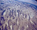
Basin and range topography is characterized by alternating parallel mountain ranges and valleys. It is a result of crustal extension due to mantle upwelling...
11 KB (1,236 words) - 16:53, 5 January 2024

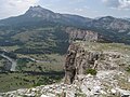
by unique basin and range topography, characterized by abrupt changes in elevation, alternating between narrow faulted mountain chains and flat arid valleys...
21 KB (2,290 words) - 22:24, 20 December 2024

and portions of California, Idaho, Oregon, Wyoming, and Baja California. It is noted for both its arid climate and the basin and range topography that...
34 KB (3,620 words) - 23:49, 4 April 2025

Mojave Desert (redirect from Mojave Basin and Range (ecoregion))
Basin deserts, form a larger North American desert. Of these, the Mojave is the smallest and driest. It displays typical basin and range topography,...
53 KB (4,046 words) - 23:10, 10 May 2025
Mojave, Sonoran, and Chihuahuan Deserts. Basin and range topography characterizes the desert: wide valleys bordered by parallel mountain ranges generally oriented...
49 KB (5,051 words) - 11:45, 6 May 2025

Fault (geology) (redirect from Synthetic and antithetic faults)
horsts on the surface of the Earth produces a characteristic basin and range topography. A listric fault is a type of normal fault that has a concave-upward...
33 KB (3,760 words) - 16:13, 16 May 2025

golden eagle, and many species of bat, lizard, and snake. Basin and Range Province Basin and range topography List of national monuments of the United States...
11 KB (1,039 words) - 06:25, 14 February 2025

Bolson (category Basins)
a type of endorheic basin characteristic of basin and range topography. The term was an Americanism originating in the 1830s and 1840s during the explorations...
2 KB (211 words) - 04:06, 1 February 2025
Basin and range topography, type of topography typical of the Basin and Range Province Basin and Range National Monument, in Lincoln and Nye counties in...
524 bytes (114 words) - 16:41, 15 May 2024

Wadi (category Canyons and gorges)
portions of alluvial fans and extend to inland sabkhas or dry lakes. In basin and range topography, wadis trend along basin axes at the terminus of fans...
10 KB (1,047 words) - 07:27, 18 May 2025
Basin and Range topography. The greater Bryce area was uplifted as part of the High Plateaus by the same forces. Uplift of the Colorado Plateaus and the...
27 KB (3,374 words) - 23:16, 4 May 2025
populations in isolated mountain and valley habitats in western North America, where the basin and range topography creates areas that are insular in...
15 KB (1,768 words) - 00:26, 29 November 2024

geology, horst and graben (or range and valley) refers to topography consisting of alternating raised and lowered fault blocks known as horsts and grabens....
3 KB (368 words) - 19:26, 11 January 2025

now more or less exposed by erosion. The large Basin and Range Province is a basin and range topography resulting from crustal extension (extensional tectonics)...
18 KB (2,637 words) - 20:52, 14 February 2025
opening of the Rhine Graben, a major extensional basin. Horst and graben Basin and range topography Fault-block mountain Plateau Originally published...
8 KB (821 words) - 19:16, 5 November 2024

number of horst and graben features on the seafloor, similar to basin and range topography. Many of the Aegean Islands are peaks from these features reaching...
7 KB (819 words) - 16:55, 18 May 2025

× 48 km) and comprising 1,500 square miles (3,900 km2). It is characterized by basin and range topography with three north south trending mountain ranges, the...
4 KB (421 words) - 18:11, 17 May 2025

North American Cordillera (category Mountain ranges of North America)
Texas, Utah, and Wyoming, as well as much of northern Mexico. It is an extremely arid region characterized by basin and range topography. The Colorado...
39 KB (4,651 words) - 22:40, 12 April 2025

region instead of moving out to sea or further inland. Basin and range topography Basin and Range Province California earthquake forecast (UCERF) Earthquake...
6 KB (546 words) - 14:41, 3 May 2025
Sevier orogeny (section How and when)
Basin and range topography Geology of the Rocky Mountains Yonkee, W. Adolph; Weil, Arlo Brandon (2015-11-01). "Tectonic evolution of the Sevier and Laramide...
25 KB (2,895 words) - 05:23, 31 December 2024

Range) gives rise to the basin and range topography of parallel ridges and basins. During the Cretaceous, regional uplift and erosion brought the Textural...
26 KB (2,702 words) - 07:46, 15 May 2025
book Basin and Range, about the origin of Basin and Range topography, Deffeyes teaches geology to McPhee and his readers by analyzing road cuts and the...
5 KB (486 words) - 17:57, 24 June 2024

extension as part of the basin and range topography of western North America. The Forest Service is in charge of 83.6% of the mountains and the Bureau of Land...
3 KB (288 words) - 04:17, 15 April 2024
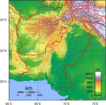
Balochistan Plateau, Salt Range, and the Sistan Basin. All the rivers of Pakistan, i.e. Sindh, Ravi River, Chenab River, Jhelum River, and Sutlej River, originate...
9 KB (1,302 words) - 17:48, 25 January 2025

which replicated the phenomena of sand dunes, a hands-on basin and range topography display, and a mock lava tube, which children could climb through. This...
15 KB (1,462 words) - 06:21, 28 February 2025

endorheic basin (/ˌɛndoʊˈriː.ɪk/ EN-doh-REE-ik; also endoreic basin and endorreic basin) is a drainage basin that normally retains water and allows no...
33 KB (3,789 words) - 00:52, 11 April 2025

Utah (category States and territories established in 1896)
corridor, and population growth is rapid. Western Utah is a mostly arid desert with a basin and range topography. Small mountain ranges and rugged terrain...
207 KB (18,159 words) - 00:26, 12 May 2025
Tuttle Ranch) Bernadette Manuelito is assigned to patrol the basin and range topography of the rugged Animas Mountains of Hidalgo County in the extreme...
21 KB (2,994 words) - 21:21, 29 March 2025

from four lanes to two and crosses remote terrain characterized by Basin and Range topography. The summits start out low and gradually increase in elevation...
60 KB (4,913 words) - 02:32, 30 April 2025

Jerome, Arizona (section Economy and culture)
15 million years ago created Basin and Range topography in central and southern Arizona, caused volcanic activity near Jerome, and induced movement along the...
66 KB (6,602 words) - 02:58, 7 May 2025