Geopotential height, also known as geopotential altitude or geopotential elevation, is a vertical coordinate (with dimension of length) representing the...
8 KB (977 words) - 16:55, 20 April 2025

Elevation (redirect from Geometric height)
when referring to points on the Earth's surface, while altitude or geopotential height is used for points above the surface, such as an aircraft in flight...
6 KB (561 words) - 17:58, 4 May 2025
Geopotential (symbol W) is the potential of the Earth's gravity field. It has SI units of square metre per square seconds (m2/s2). For convenience it is...
12 KB (1,766 words) - 17:58, 2 August 2025

Tropical cyclone (section Geopotential height)
geopotential heights are used when creating forecasts and analyzing pressure systems. Geopotential heights represent the estimate of the real height of...
224 KB (21,901 words) - 01:05, 16 July 2025
H {\displaystyle H} = geopotential height at which pressure is calculated (m) H b {\displaystyle H_{b}} = geopotential height of reference level b (meters;...
9 KB (1,108 words) - 02:50, 19 July 2025
Vertical position (redirect from Geopotential metre)
Drying height Dynamic height Ellipsoidal height Geocentric altitude Geopotential Height above mean sea level Height above average terrain Height above...
8 KB (837 words) - 02:51, 21 February 2025

oscillation index is defined using the daily or monthly 1000 hPa geopotential height anomalies from latitudes 20° N to 90° N. The anomalies are projected...
14 KB (1,530 words) - 21:44, 28 August 2024

geostrophic wind at a given pressure level flows along geopotential height contours on a map, and the geopotential thickness of a pressure layer is proportional...
12 KB (1,498 words) - 11:58, 16 December 2024
alternative for orthometric height or normal height. It can be computed (in SI units of metre) by dividing the location's geopotential number (symbol C, in square...
3 KB (355 words) - 02:38, 21 March 2025
of warmer air increases pressure levels which decreases poleward geopotential height gradients. As these gradients are the reason that cause west to east...
83 KB (9,033 words) - 03:48, 7 July 2025

Contour line (redirect from Height Contours)
constant density. An isoheight or isohypse is a line of constant geopotential height on a constant pressure surface chart. Isohypse and isoheight are...
38 KB (4,496 words) - 06:30, 9 July 2025
\nabla \cdot \mathbf {v} ,} (6) where Φ {\displaystyle \Phi } is the geopotential height. Writing the absolute vorticity as ζ a = ∇ × v + 2 Ω {\textstyle...
24 KB (3,795 words) - 17:50, 15 July 2025

in the fields of atmospheric variables (like surface pressure or geopotential height, temperature, or wind velocity) which may either propagate (traveling...
5 KB (594 words) - 10:49, 12 May 2025

of warmer air increases pressure levels which decreases poleward geopotential height gradients. As these gradients are the reason that cause west to east...
29 KB (6,235 words) - 09:52, 22 July 2025
Arctic oscillation. Omega blocks are so-named because the isobars or geopotential height contours with which they are associated in the Northern Hemisphere...
17 KB (1,946 words) - 20:30, 23 June 2025

contrasts play no role in its formation. Given a grid point field of geopotential height, storm tracks can be visualized by contouring its average standard...
2 KB (229 words) - 21:37, 6 May 2024
computer for the first time, using an observed field of 500 hPa geopotential height for the first timestep. This was one of the first successful instances...
3 KB (433 words) - 15:17, 21 December 2024

respect to height, and thus the baroclinicity in the atmosphere can be simulated using the 500 mb (15 inHg) and 1,000 mb (30 inHg) geopotential height surfaces...
44 KB (5,669 words) - 06:24, 4 April 2025

with an assumed linear distribution of absolute temperature T against geopotential altitude h. The other two values (pressure P and density ρ) are computed...
8 KB (721 words) - 00:42, 7 June 2024

Normalhöhennull (section Old East German height system)
reference height is a geodetic, fixed point on the New Church of St. Alexander at Wallenhorst in the German state of Lower Saxony. The geopotential height of...
6 KB (572 words) - 00:08, 23 July 2024

Geoid (redirect from Geoid height)
orthometric heights, geopotential heights, and dynamic heights (see Geodesy). All points on a geoid surface have the same geopotential (the sum of gravitational...
29 KB (3,444 words) - 09:22, 15 July 2025

one January, and one in March. Zonal mean temperature, wind, and geopotential height exert varying deviations from their normal values before and after...
38 KB (7,307 words) - 21:18, 5 July 2025

Sea level (section Height above mean sea level)
measured Extreme points of Earth Geopotential height – Type of altitude above mean sea level Height above average terrain – Height based on large area surrounding...
21 KB (4,033 words) - 02:22, 19 July 2025

{\varphi }}_{1}-{\boldsymbol {\varphi }}_{0}\right)\,,} where the φ are geopotential height fields with φ1 > φ0, f is the Coriolis parameter, and k is the upward-pointing...
29 KB (3,346 words) - 15:56, 3 November 2024

a cyclonic northward deflection of the trade winds. Asiatic low Geopotential height Surface weather analysis The Hong Kong Observatory, Weather Map at...
10 KB (1,247 words) - 12:47, 5 August 2025
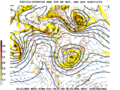
movement of Rossby waves (that is, the troughs and ridges of 500 hPa geopotential height) over a limited amount of time (a few days). In the 1950s, the first...
23 KB (2,718 words) - 04:08, 19 May 2025
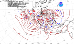
An example of 500 mbar geopotential height and absolute vorticity prediction from a numerical weather prediction model...
76 KB (7,769 words) - 08:30, 5 August 2025
Ridge was characterized by a broad region of anomalously positive geopotential height on monthly to annual timescales. This persistent high pressure system...
13 KB (1,164 words) - 13:38, 18 July 2025
The proportional symbol technique uses point symbols of different sizes (height, length, area, or volume) to represent quantitative statistical values associated...
28 KB (3,084 words) - 15:29, 26 May 2025
{\displaystyle z} coordinate with a pressure coordinate system, in which the geopotential heights of constant-pressure surfaces become dependent variables, greatly...
70 KB (7,628 words) - 08:48, 24 June 2025