
Kootenay National Park is a national park of Canada in southeastern British Columbia. The park consists of 1,406 km2 (543 sq mi) of the Canadian Rockies...
37 KB (3,799 words) - 10:44, 18 May 2024

The Kootenays or Kootenay (/ˈkuːtni/ KOOT-nee) is a region of southeastern British Columbia. It takes its name from the Kootenay River, which in turn was...
11 KB (1,014 words) - 14:16, 16 May 2024
The Kootenay River or Kootenai River is a major river of the Northwest Plateau in southeastern British Columbia, Canada, and northern Montana and Idaho...
96 KB (10,722 words) - 08:42, 21 May 2024

landscapes. Provincial forests and Yoho National Park are neighbours to the west, while Kootenay National Park is located to the south and Kananaskis Country...
87 KB (9,223 words) - 22:00, 18 May 2024

in southeastern British Columbia, bordered by Kootenay National Park to the south and Banff National Park to the east in Alberta. The word Yoho is a Cree...
12 KB (1,083 words) - 11:09, 18 May 2024

Radium Hot Springs, British Columbia (category Populated places in the Regional District of East Kootenay)
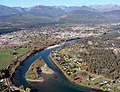
residents in the East Kootenay region of British Columbia. The village is named for the hot springs in the nearby Kootenay National Park. From Banff, Alberta...
9 KB (561 words) - 18:34, 20 April 2024
Kootenay River in British Columbia, Canada Kootenay National Park, a national park in British Columbia at the source of the Kootenay River Kootenay Pass...
3 KB (401 words) - 19:58, 27 January 2024

Montana, United States. Waterton was the fourth Canadian national park, formed in 1895 as Kootenay Lakes Forest Reserve. It is named after Waterton Lake...
26 KB (2,314 words) - 11:26, 18 May 2024

coordinates) GPX (secondary coordinates) Canada's national parks are protected areas under the Canada National Parks Act, owned by the Government of Canada and...
82 KB (3,183 words) - 22:31, 21 May 2024

Burgess Shale (category Yoho National Park)
near the town of Field in Yoho National Park and the Kicking Horse Pass. Another outcrop is in Kootenay National Park 42 km to the south. The Burgess...
23 KB (2,512 words) - 14:42, 1 May 2024

The Regional District of East Kootenay (RDEK) is a regional district in the Canadian province of British Columbia, Canada. In the 2016 census, the population...
21 KB (782 words) - 08:46, 20 April 2024
British Columbia Highway 93 (redirect from Kootenay Highway)
8 mi) to the western gate of Kootenay National Park. Through the park, the highway travels northeast along the Kootenay and Vermilion rivers for 93 km...
10 KB (645 words) - 22:55, 22 September 2022
Banff–Windermere Highway (category Kootenay National Park)
(midway between Banff and Lake Louise), passing through Kootenay National Park and Banff National Park. It is designated as part of British Columbia Highway...
12 KB (978 words) - 22:50, 10 May 2023

Mount Kindersley (category Kootenay National Park)
is located 12 kilometres (7.5 mi) north of Radium Hot Springs in Kootenay National Park. The peak is the second-highest point of the Brisco Range which...
4 KB (278 words) - 18:52, 16 May 2024
Mount Ball (category Kootenay National Park)
located on the Continental Divide, on the borders of Banff and Kootenay national parks in Western Canada. Mt. Ball is the highest peak of the Ball Range...
5 KB (397 words) - 10:10, 30 October 2023

Great Divide Trail (category Kootenay National Park)
trails. The GDT passes through five National Parks: Waterton Lakes, Banff, Kootenay, Yoho and Jasper; nine Provincial Parks: Akamina-Kishinena, Castle, Castle...
7 KB (764 words) - 04:03, 6 March 2022
Haiduk Peak (category Kootenay National Park)
is located on the Continental Divide on the border of Banff and Kootenay National Parks at the head of Haiduk Creek. The mountain was named in 1917, probably...
2 KB (112 words) - 12:22, 29 October 2023

Kootenay National Park". National Park Service. Archived from the original on 2019-09-29. Retrieved 2020-09-23. "Geology Fieldnotes". National Park Service...
29 KB (3,142 words) - 21:29, 17 March 2024
British Columbia Simpson Peninsula, Nunavut Simpson River, a river in Kootenay National Park, British Columbia (also North Simpson River) Simpson's River, a...
3 KB (323 words) - 07:17, 22 September 2023
Fay hut (category Kootenay National Park)
The Fay hut was an alpine hut located above Prospectors Valley in Kootenay National Park, British Columbia. Although the higher Neil Colgan hut superseded...
21 KB (2,058 words) - 01:53, 20 November 2022

Deltaform Mountain (category Kootenay National Park)
Columbia and Alberta, and also on the border between Banff and Kootenay National Parks in Canada. The mountain was originally named Saknowa by Samuel...
4 KB (301 words) - 07:02, 25 October 2023
Fieldnotes". National Park Service. Archived from the original on 2013-05-22. Retrieved 2010-11-28. "Backpacking - Kootenay National Park". National Park Service...
18 KB (2,088 words) - 08:37, 8 December 2023

Mount Sinclair (category Kootenay National Park)
located nine kilometres (5.6 mi) north of Radium Hot Springs in Kootenay National Park. The peak is the third-highest point of the Stanford Range which...
5 KB (338 words) - 03:10, 17 May 2024

Shale and 44 specimens found in 2012 at the Marble Canyon bed in Kootenay National Park. Whilst named after the Ediacaran organism Spriggina, later work...
10 KB (956 words) - 02:07, 8 September 2023

from British Columbia Highway 95 at Radium Hot Springs, through Kootenay National Park and Vermilion Pass across the Continental Divide, to the junction...
18 KB (1,011 words) - 08:07, 20 April 2024

clusters of national parks including Mount Revelstoke National Park, Glacier National Park (Canada), Yoho National Park, and Kootenay National Park on the...
95 KB (10,305 words) - 09:45, 13 May 2024
National Recreation Area Flathead Lake In Canada, the mountain range contains these national parks: Banff National Park Jasper National Park Kootenay...
54 KB (5,464 words) - 08:14, 2 May 2024

Continental Divide between Vermilion Pass and Red Earth Pass in Kootenay National Park, Canada. The range is named after John Ball, a politician who helped...
3 KB (146 words) - 05:18, 2 October 2023

a Burgess Shale locality known as the Tokumm Creek in northern Kootenay National Park. Ursactis is the most abundant Cambrian polychaete found as of 2023...
2 KB (185 words) - 10:49, 16 January 2024

Isabelle Peak (category Kootenay National Park)
peak located on the Continental Divide on the border of Banff and Kootenay National Parks in the Canadian Rockies. The mountain was named in 1913 by R.D...
4 KB (267 words) - 03:02, 15 August 2021