
Route 3A, also known as Team Gushue Highway, is a currently 6.6-kilometre-long (4.1 mi) north-south freeway on the Avalon Peninsula of Newfoundland in...
7 KB (610 words) - 21:57, 8 March 2025
This is a list of highways in Newfoundland and Labrador. Newfoundland and Labrador is unusual among jurisdictions in Canada in that it exclusively uses...
39 KB (2,795 words) - 03:06, 2 March 2024

The Trans-Labrador Highway (TLH) is the primary public road in Labrador, the mainland portion of the province of Newfoundland and Labrador, Canada. The...
25 KB (1,536 words) - 11:01, 17 February 2025
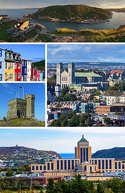
St. John's is the capital and largest city of the Canadian province of Newfoundland and Labrador. It is located on the eastern tip of the Avalon Peninsula...
160 KB (13,404 words) - 19:07, 8 June 2025

Newfoundland and Labrador. It leads from Sheppardville, at Route 1 (Trans-Canada Highway), to a dead end in Fleur de Lys, Newfoundland and Labrador....
5 KB (314 words) - 03:31, 24 May 2025

Avalon Peninsula of Newfoundland in the Canadian province of Newfoundland and Labrador. Its southern terminus is at Route 10 in Goulds and its northern terminus...
4 KB (295 words) - 01:44, 16 July 2024

of Newfoundland and Labrador. Its eastern terminus is the intersection at the Trans-Canada Highway (Route 1) in the Town of Badger, and the route ends...
4 KB (312 words) - 01:44, 16 July 2024

Route 30 is a 12.0-kilometre-long (7.5 mi) north-south provincial highway in Newfoundland and Labrador, extending from St. John's through Logy Bay-Middle...
3 KB (180 words) - 23:28, 14 February 2024

province of Newfoundland and Labrador. The road provides a direct link from the Trans-Canada Highway (TCH) to downtown St. John's, Newfoundland, which was...
10 KB (653 words) - 22:11, 30 August 2024

Peninsula of Newfoundland in the Canadian province of Newfoundland and Labrador. It extends from the city of St. John's west to Paradise. Route 50 begins...
4 KB (256 words) - 23:29, 14 February 2024

Route 470, also known as La Poile Highway, is a highway on the West Coast of the Canadian province of Newfoundland and Labrador. It is the last provincial...
5 KB (368 words) - 01:44, 16 July 2024
Route 1 is a highway in the Canada province of Newfoundland and Labrador, and is the easternmost stretch of the Trans-Canada Highway. Route 1 is the primary...
32 KB (1,175 words) - 00:58, 24 December 2024

Route 463, also known as Lourdes Road, is a rural highway in Newfoundland and Labrador that leads from Route 460 at Abraham's Cove to Cape St. George....
4 KB (229 words) - 06:40, 24 December 2024

Cove-St. Philips in Newfoundland and Labrador, Canada. Route 40 also serves as the primary access to St. John's International Airport and the Bell Island...
4 KB (271 words) - 21:09, 30 August 2024

Newfoundland in the Canadian province of Newfoundland and Labrador. It begins at a junction of Route 430 in Wiltondale and terminates at Trout River. It serves...
4 KB (244 words) - 18:21, 5 April 2024
3A: Alberta Highway 3A British Columbia Highway 3A Manitoba Highway 3A Newfoundland and Labrador Route 3A (Team Gushue Highway) Nova Scotia Trunk 3A (former)...
1 KB (98 words) - 15:53, 26 June 2024
turn and coming to an end shortly thereafter at another intersection with Route 235 (Church Street). As with most highways in Newfoundland and Labrador, the...
12 KB (593 words) - 01:43, 16 July 2024

Canadian province of Newfoundland and Labrador. The route begins at the intersection of Route 1 (The Trans Canada Highway) in Deer Lake and ends in St. Anthony...
14 KB (825 words) - 18:21, 5 April 2024

Province of Newfoundland and Labrador. It connects the towns of Roddickton, Bide Arm, Main Brook, along with many other smaller communities, with Route 430 (Great...
4 KB (186 words) - 18:21, 5 April 2024

in the Canadian province of Newfoundland and Labrador. It connects the town of Burgeo with the Trans-Canada Highway (Route 1). The highway is a winding...
4 KB (286 words) - 16:35, 18 April 2023

kind in the entire province of Newfoundland and Labrador. Route 520 begins at an intersection with Route 500 (Trans Labrador Highway) at the western edge...
4 KB (225 words) - 23:55, 10 May 2023

the Canadian province of Newfoundland and Labrador. The highway begins at a junction with Route 1 (Trans-Canada Highway) and continues to its west terminus...
3 KB (186 words) - 15:42, 22 October 2022

of Newfoundland and Labrador. It connects the town of Cartwright, along with the community of Paradise River, with the Trans-Labrador Highway (Route 510)...
4 KB (260 words) - 20:58, 14 July 2024

Route 239 is a highway in the Trinity Bight portion of Newfoundland in the Canadian province of Newfoundland and Labrador. It is a short route, running...
3 KB (216 words) - 15:16, 22 October 2022
Route 220 is the southern portion of the Heritage Run in the Canadian province of Newfoundland and Labrador, running along the southern and western coastlines...
9 KB (517 words) - 06:11, 1 September 2024
Route 404 is a short provincial highway on the west coast of Newfoundland in the Canadian province of Newfoundland and Labrador. It is one of four provincial...
4 KB (213 words) - 01:44, 16 July 2024

the Canadian province of Newfoundland and Labrador. It serves as the only roadway access to the eastern half of the island. Route 334 begins in Fogo Island...
2 KB (132 words) - 01:43, 16 July 2024

Route 360, also known as Bay d'Espoir Highway, is a provincial highway in Newfoundland and Labrador. It runs from the Bishop's Falls area to Bay d'Espoir...
7 KB (426 words) - 01:44, 16 July 2024

highway on the Avalon Peninsula of Newfoundland. It runs between the town of Cupids and the city of St. John's. Route 60 begins as Topsail Road at the west...
8 KB (342 words) - 06:57, 16 January 2023

dead end near the western tip of the island. List of Newfoundland and Labrador highways "Route 350" (Map). Google Maps. Retrieved February 21, 2020....
5 KB (356 words) - 15:28, 22 October 2022