
Ocean Reef Road is an arterial east-west road in Perth, Western Australia. It is located within the northern suburbs of Perth, from Ocean Reef in the west...
11 KB (1,278 words) - 02:59, 9 January 2024
Ocean Reef Marina is a development project in Ocean Reef, Western Australia to construct a new marina with commercial and residential areas at the existing...
35 KB (4,614 words) - 00:29, 30 April 2024

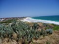
Ocean Reef is a suburb in northern Perth, Western Australia. It is located within the City of Joondalup. The name was coined by developers in the 1970s...
5 KB (580 words) - 10:28, 31 October 2023

The Great Ocean Road is an Australian National Heritage-listed 240-kilometre (150 mi) stretch of road along the south-eastern coast of Australia, between...
33 KB (2,870 words) - 20:53, 21 May 2024
Mitchell Freeway (category WikiProject Australian Roads articles with a junction list using templates)
in Osborne Park. By the end of the 1980s, the freeway had reached Ocean Reef Road in Edgewater. The Joondalup railway line was constructed in the freeway...
66 KB (5,585 words) - 01:20, 15 January 2024

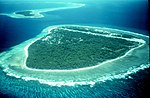
A fringing reef is one of the three main types of coral reef. It is distinguished from the other main types, barrier reefs and atolls, in that it has...
15 KB (1,851 words) - 15:09, 30 April 2024

the north by Ocean Reef Road and to the east by Wanneroo Road. Trappers Drive runs through Woodvale, from Whitfords Avenue to Ocean Reef Road. The area within...
4 KB (390 words) - 12:20, 21 April 2023
Oceanside Promenade and Ocean Reef Road 461 Whitfords Station to Joondalup Station – serves Dampier Avenue and Ocean Reef Road 462 Whitfords Station...
4 KB (312 words) - 10:33, 7 May 2024

reaching Ocean Reef Road, which is a grade-separated interchange with Wanneroo Road free-flowing over traffic light junctions at Ocean Reef Road. North...
21 KB (1,775 words) - 12:50, 8 January 2024
years, about 70 to 90% of all coral reefs will disappear. With primary causes being warming ocean waters, ocean acidity, and pollution. In 2008, a worldwide...
93 KB (10,536 words) - 03:06, 4 June 2024
Joondalup (section Road transport)
Joondalup and wetlands which stretches out between Burns Beach Road to the north and Ocean Reef Road to the south. These wetlands provide refuge for migratory...
16 KB (1,882 words) - 10:20, 8 May 2024
Gnangara Road provides a connection between Great Northern Highway (via West Swan Road) and Wanneroo Road. The construction of the Ocean Reef Road extension...
15 KB (898 words) - 12:19, 22 January 2024

Waterpocket Fold. Locally, reef refers to any rocky barrier to land travel, just as ocean reefs are barriers to sea travel. Capitol Reef encompasses the Waterpocket...
40 KB (4,226 words) - 22:26, 6 March 2024
Beldon, Western Australia (section Roads)
Whitfords Station to Joondalup Station – serves Craigie Drive and Ocean Reef Road Though not directly served, the nearest train station is Edgewater...
7 KB (726 words) - 11:37, 23 April 2024

Marmion Avenue (category Infobox Australian road articles with an infobox mapframe map)
Avenue is managed by Main Roads Western Australia after previously being managed by the City of Joondalup from Ocean Reef Road to the City of Joondalup-Wanneroo...
26 KB (1,841 words) - 08:52, 9 May 2024
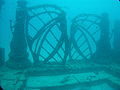
through, requiring a re-engineering of the Reef. The reef stretches across 16 acres (65,000 m2) of ocean floor designed as both a home for sea life and...
6 KB (598 words) - 01:27, 28 November 2023

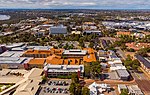
City of Joondalup (section Roads)
would be involved in the planning and development. June 1992 saw the Ocean Reef Road bridge at the end of the Mitchell freeway open and the tender for the...
54 KB (5,561 words) - 01:32, 4 June 2024
north, Admiral Grove to the east, Ocean Reef Road to the south, and Marmion Ave via Mermaid Way and Poseidon Road to the west. The Metropolitan Region...
12 KB (1,367 words) - 10:18, 10 April 2024

Key Largo (redirect from Ocean Reef, Florida)
able to dissipate up to 97% of the oceanic wave forces exerted during hurricanes and other tropical storms, with the reef serving as a protective buffer against...
13 KB (1,207 words) - 16:03, 13 May 2024

of the suburb. Edgewater is bounded by Joondalup Drive to the west, Ocean Reef Road to the south and Yellagonga Regional Park to the east. Edgewater is...
3 KB (238 words) - 05:11, 24 July 2022
Joondalup Drive (category Infobox Australian road articles with an infobox mapframe map)
Highway from the Mitchell Freeway. The route from Ocean Reef Road to Burns Beach Road was gazetted as Road No. 10951 by the Shire of Wanneroo in 1953. Joondalup...
10 KB (1,106 words) - 03:12, 9 January 2024
with Gnangara. Gnangara is bounded by Ocean Reef Road and Gnangara Road to the south, Badgerup Road and Ross Road to the west and the Gnangara Pine Plantation...
3 KB (291 words) - 09:55, 22 March 2024

of animals and algae. Slowly and over time, the reefs build up to the surface in oceans. Coral reefs are found in shallow, warm salt water. The sunlight...
61 KB (8,018 words) - 04:35, 18 May 2024
Road routes in Western Australia assist drivers navigating roads in urban, rural, and scenic areas of the state. The route numbering system is composed...
81 KB (2,134 words) - 15:09, 24 April 2024
Mirrabooka Avenue (category Infobox Australian road articles with an infobox mapframe map)
northern end, it is continuous with Gnangara Road, which meets up with Ocean Reef Road and state route 84. In 2010, construction started on a diamond interchange...
7 KB (240 words) - 19:36, 8 June 2023
Tourist Drives in Western Australia (redirect from Caves Road Tourist Drive)
Hillarys, Mullaloo, and finally Ocean Reef, travelling along Challenger Parade, West Coast Highway, Karrinyup Road, West Coast Drive, Whitfords Avenue...
37 KB (3,154 words) - 00:17, 5 January 2024

Reef, which includes West, Middle and East Islands, in addition to two lagoons, as well as Cartier Reef, which includes Cartier Island. Ashmore Reef covers...
21 KB (2,045 words) - 14:03, 11 April 2024

North Beach Road remain as a reminder of earlier times. The Mitchell Freeway's extension to Erindale Road in 1984 and to Ocean Reef Road in 1986-87 facilitated...
14 KB (1,435 words) - 10:39, 31 March 2023
by the boundaries formed by Wanneroo Road and the Mitchell Freeway in an east–west alignment and Ocean Reef Road to the north. The south border is in...
9 KB (797 words) - 20:05, 23 April 2024
Street, London W1D 3JB Freeport Tribune, August 2008 Baker's Bay Golf & Ocean Club Save Guana Cay Reef Global Coral Reef Alliance Mangrove Action Project...
4 KB (459 words) - 12:23, 23 August 2020