
The Parque Nacional de las Cavernas del Río Camuy (English: Camuy River Cave National Park) is a cave system in Puerto Rico. It is located between the...
9 KB (881 words) - 04:39, 4 June 2024
Puerto Rico located in Camuy, Parque Nacional de las Cavernas del Río Camuy was destroyed, and would remain closed for four years. Camuy belongs to the zone...
38 KB (2,934 words) - 22:14, 10 December 2023
El Yunque National Forest (category Museums in Rio Grande, Puerto Rico)
2002, the U.S. Congress designated areas bounded by the Río Mameyes, Río de la Mina, and Río Icacos in the Caribbean National Forest as components of...
57 KB (6,063 words) - 18:54, 13 May 2024

com. Retrieved 21 July 2018. "Reconocen a Flamenco como una de las mejores 25 playas del mundo". Elnuevodia.ocm. 22 February 2017. Retrieved 21 July 2018...
12 KB (1,007 words) - 22:28, 5 May 2024
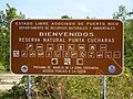
22, 1981. Reserva Natural Isla Caja de Muertos: Laboratorio Natural para Fomentar el Estudio de las Aves dentro del Escutismo. Javier González Delgado...
32 KB (3,599 words) - 17:50, 2 June 2024
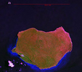
Del norte, Ataúd, Nuevos Lirios and Gallinas on Isla de Mona, with thousands of examples of native art, marks and later on, graffiti. The Isla de Mona...
36 KB (3,494 words) - 13:34, 6 May 2024

part of the Isla de Cabras State Park (often referred to as Parque Nacional Isla de Cabras as state parks in Puerto Rico are called parques nacionales in...
23 KB (2,469 words) - 21:02, 25 January 2024

Rincón, Añasco, Mayagüez, Las Marías, Maricao, Hormigueros, San Germán, Sabana Grande, Guánica, Lajas and Cabo Rojo. The Porta del Sol tourism region was...
21 KB (1,883 words) - 22:17, 19 March 2024
Arecibo Observatory, Cueva Ventana and Cueva del Indio. Another prominent landmark of the region is the Camuy River Caverns, one of the largest of its type...
48 KB (5,337 words) - 05:44, 4 June 2024
Xtabi Cueva de Los Indios Cueva del Indio Cuevas Las Cabachuelas Cueva Lucero Cueva Ventana Parque Nacional de las Cavernas del Río Camuy Pozo de Jacinto...
69 KB (5,526 words) - 12:43, 14 May 2024
Las Bocas Canyon (Spanish: Cañón Las Bocas) is a steep gorge formed by the Frío River (Río Frío) and numerous other creeks, primarily the Hondo River (Río...
5 KB (461 words) - 18:34, 7 September 2023
Aguas Buenas Cave System (redirect from Sistema de cuevas y cavernas de Aguas Buenas)
The Aguas Buenas Cave System (Spanish: Sistema de cuevas y cavernas de Aguas Buenas) is a cave system located in the municipality of Aguas Buenas. The...
4 KB (406 words) - 20:29, 25 February 2023

"Beaches". Retrieved 21 October 2011. El Parque Acuatico de Ponce... ¿Tenía permisos? Alex David. La Opinión del Sur. 14 July 2010. Page 2. Retrieved 10...
11 KB (1,118 words) - 12:44, 20 April 2024

Bahía de Jobos has continued to change. The Corporacion Amoros private reserve borders the Aguirre State Forest on the East, a fisherman village (Las Mareas)...
6 KB (615 words) - 14:35, 6 May 2024
August 18, 2010. OFICINA DEL GOBERNADOR, JUNTA DE PLANIFICACIÓN (December 22, 2016). "PLAN SECTORIAL PARA LA RESERVA NATURAL DE RÍO CIALITOS" (PDF). pr.gov...
53 KB (1,674 words) - 14:50, 4 June 2024

Retrieved 23 July 2022. "Río Abajo Forest Reserve (Bosque Estatal de Río Abajo ) | NatureFind". Retrieved 2021-12-14. "Los beneficios de hacer senderismo en...
10 KB (949 words) - 20:42, 17 January 2024

List of protected areas of Puerto Rico (section State Parks (Parques Nacionales de Puerto Rico) and other protected areas)
Chalets de Bairoa Natural Area (Caguas) Cerro Borrás (Caguas) Río Hondo Community Forest (Mayagüez) "Directorio de agencias - Compañía de Parques Nacionales...
14 KB (968 words) - 17:45, 18 November 2023
Punta Salinera, el Río del Real Anón, Isla de Caja de Muerto e Isla de Cardona. CyberNews. 3 July 2019. Ponce, Puerto Rico: La Perla del Sur. Accessed 6...
41 KB (2,487 words) - 03:44, 2 December 2023
in Puerto Rico. Aguas Buenas Cave System Cavernas del Río Camuy Cueva de Los Indios Cueva del Indio Cueva del Indio (Arecibo) Cueva La Espiral Cueva Lucero...
720 bytes (43 words) - 15:18, 27 May 2023
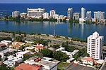
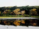
Condado Lagoon (redirect from Laguna del Condado)
Retrieved 2021-01-08. Media related to Condado Lagoon at Wikimedia Commons Lagos De Puerto Rico Parque Laguna del Condado Official state website (in Spanish)...
3 KB (249 words) - 03:36, 8 August 2022

Ortiz (2012-01-12). "En las entrañas de Adjuntas un bosque para el pueblo". Atabey (in Spanish). Retrieved 2021-10-10. "Bosque del Pueblo". Casa Pueblo •...
5 KB (468 words) - 21:25, 9 August 2023
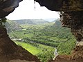
situated atop a limestone cliff in Arecibo, Puerto Rico, overlooking the Río Grande de Arecibo valley. It is visible from the PR-123 but is accessible from...
5 KB (431 words) - 20:52, 20 February 2023

(257): 75–84 – via ufl.edu. "Los Bosques de Puerto Rico - EnciclopediaPR". 2014-08-27. Retrieved 2023-09-05. "Parques y reservas". Discover Puerto Rico (in...
36 KB (2,205 words) - 23:37, 23 May 2024

Pelicans being fed on Crash Boat Puerto Rico portal Flamenco Beach La Pocita de Isabela List of beaches in Puerto Rico Puerto Rico Tourism Company Smith,...
4 KB (245 words) - 19:01, 26 December 2023
Resources (DRNA), then the park will be properly established as Parque Nacional Las Cabachuelas. Taíno "Nueva opción al turismo para explorar cuevas...
6 KB (492 words) - 00:17, 20 March 2023

San Cristóbal Canyon (redirect from Cañón de San Cristóbal)
flow of the Usabón River, an eastward tributary of the La Plata River (Río de la Plata), which at approximately 46 miles (74 km) is the longest river...
10 KB (1,230 words) - 13:20, 13 March 2024
Petroglyph Group (Spanish: Grupo de Petroglifos de Icacos), also known as the Río Blanco Petroglyphs (Petroglifos de Río Blanco), is an ensemble of indigenous...
6 KB (646 words) - 10:22, 5 May 2024

mountain towns and scenic vistas of the Cordillera Central. Bosque del Pueblo Camuy River Caves Park (partial) El Rabanal Conservation Easement Foreman...
15 KB (1,208 words) - 11:47, 5 October 2023

Toro Negro State Forest (redirect from Bosque Estatal de Toro Negro)
south (Río Indalecia, Río Guayo, Río Inabón, Río Blanco, Río Anón and Río Prieto), and three that flow north (Río Saliente, Río Toro Negro, and Río Matrullas)...
99 KB (10,192 words) - 02:52, 24 May 2024
Reserva Natural Punta Cucharas (redirect from Las Cucharas)
Accessed 8 June 2016. Informe Final del Proyecto de Monitoreo Socioeconómico en las Áreas Protegidas Marinas y Costeras de Puerto Rico: Reserva Natural Punta...
62 KB (4,533 words) - 02:04, 19 January 2024