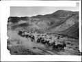
Sierra Highway or El Camino Sierra is a road in Southern California, United States. El Camino Sierra refers to the full length of a trail formed in the...
24 KB (1,974 words) - 07:37, 27 September 2023
The Trans-Sierra Highway was a potential highway project proposed to traverse the Sierra Nevada, connecting the Central Valley of California to regions...
7 KB (694 words) - 10:47, 4 January 2024

California State Route 14 (redirect from California State Highway 14)
SR 14 from Silver Queen Road north of Rosamond to Mojave is known as Sierra Highway, as is the old routing between I-5 and Silver Queen Road where SR 14...
37 KB (3,395 words) - 01:12, 21 November 2023

Santa Clarita, California (section Highways)
interchange of I-5 and CA-14 collapsed, and Sierra Highway became the only route in and out of the valley; Sierra Highway was soon closed as well. Several surface...
157 KB (15,616 words) - 15:11, 22 May 2024

The Sierra Nevada (/siˌɛrə nɪˈvædə, -ˈvɑːd-/ see-ERR-ə niv-A(H)D-ə) is a mountain range in the Western United States, between the Central Valley of California...
70 KB (7,049 words) - 19:44, 22 May 2024

known as Highway 6, then Highway 14, and finally the present-day Sierra Highway. The cut for the tunnel is located to the west of today's Highway 14, and...
12 KB (1,471 words) - 10:10, 15 May 2024

California State Route 168 (redirect from Sierra Freeway)
168) is an east-west state highway in the U.S. state of California that is separated into two distinct segments by the Sierra Nevada. The western segment...
17 KB (1,484 words) - 06:08, 22 August 2023

codes mostly follows Sierra Highway - addresses west of or along the highway are in 91351, while addresses east of the highway are in 91387. ZIP codes...
13 KB (1,246 words) - 13:41, 13 December 2023

Sierra Leone, officially the Republic of Sierra Leone, is a country on the southwest coast of West Africa. It shares its southeastern border with Liberia...
228 KB (24,678 words) - 07:21, 22 May 2024

Chevrolet Silverado (redirect from GMC Sierra)
Silverado and Sierra models received the General Motors Super Cruise semi-autonomous driving system, allowing for hands-free driving on most highways, and all...
110 KB (10,185 words) - 01:26, 23 May 2024
dubbed "the Naturalist Queen of the Eastern Sierra". Starting in 1958, Smith lobbied against a Trans-Sierra Highway starting at Minaret Summit near Mammoth...
4 KB (308 words) - 05:18, 13 December 2022

known as US Highway 6, then state Highway 14, and finally the present-day Sierra Highway. The cut for the tunnel is west of today's Highway 14. Butterfield...
7 KB (795 words) - 19:58, 8 January 2024

U.S. Route 6 in California (category U.S. Highways in California)
Southern California. It traveled along with what is now US 395, SR 14 (Sierra Highway), I-5, I-110/SR 110, and SR 1. When the Four Level Interchange was constructed...
10 KB (1,071 words) - 09:13, 25 February 2024

Avenue P and south of Columbia Way (Avenue M). The western border is Sierra Highway, and the plant extends east to around 40th Street East, south of Avenue...
18 KB (1,841 words) - 00:57, 22 May 2024
number 652. Mule Team Borax Terminus was located at what is now 16246 Sierra Highway, Mojave, California. California Historical Landmark status was given...
15 KB (1,965 words) - 06:39, 7 March 2024
sequences were filmed on the Sierra Highway, Agua Dulce Canyon Road, Soledad Canyon Road, and Angeles Forest Highway. Spielberg insisted on shooting...
53 KB (6,457 words) - 21:41, 8 May 2024
Sierra Entertainment, Inc. (formerly On-Line Systems and Sierra On-Line, Inc.) was an American video game developer and publisher founded in 1979 by Ken...
58 KB (6,297 words) - 22:00, 16 May 2024

Ecuador Highway 35 (E-35), officially named "Troncal de la Sierra" (Highland's Road) but colloquially known as "La Panamericana", is a primary highway in Ecuador...
2 KB (124 words) - 18:55, 30 October 2023
(secondary coordinates) This is a table of principal paved highway passes on or near the crest of the Sierra Nevada, United States. The road passes are generally...
17 KB (830 words) - 09:03, 7 January 2024

Donner Pass (category Lincoln Highway)
nearby highway could be plowed sufficiently for a caravan of automobiles to carry them the few miles to Nyack Lodge. In the spring of 1868, the Sierra Nevada...
21 KB (2,125 words) - 15:33, 4 May 2024

U.S. Route 395 in California (redirect from California State Highway 395)
several names including El Camino Sierra. The route of US 395 in California is split into two segments, as the highway exits and reenters California via...
53 KB (4,632 words) - 05:46, 6 May 2024

California State Route 49 (redirect from California State Highway 49)
in the State Scenic Highway System, and from the Sierra-Yuba county line to Yuba Summit is officially designated as a scenic highway by the California Department...
36 KB (2,930 words) - 12:41, 26 April 2024

California Roads portal "Sierra Vista Scenic Byway". American's Byways. Federal Highway Administration. Retrieved June 20, 2011. "Sierra Vista Scenic Byway:...
5 KB (466 words) - 03:36, 1 March 2024

Interstate 80 in California (redirect from Eastshore Highway)
US 40/Lincoln Highway route over Donner Pass is about two miles (3.2 km) to the south. This highway was replaced as the official trans-Sierra route by I-80...
69 KB (4,647 words) - 06:08, 12 May 2024

Minaret Summit (category Mountain passes of the Sierra Nevada (United States))
Minaret Summit is a mountain pass on Highway 203 in the central Sierra Nevada. The pass, lying on the Madera-Mono County border, is within the Mammoth...
5 KB (449 words) - 05:45, 7 July 2023
Sierra Valley is a large mountain valley located east of the crest of California's Sierra Nevada mountain range in Plumas and Sierra Counties, north of...
4 KB (441 words) - 15:21, 26 February 2024
its route parallel the former US Route 6, now San Fernando Road and Sierra Highway. This is the only Metrolink line contained entirely within Los Angeles...
21 KB (1,797 words) - 04:12, 21 April 2024
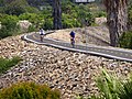
path is between Alamitos Avenue on the west to 54th Place on the east. Sierra Highway Bike Path – runs 7.1 miles in the Antelope Valley, from East Avenue...
37 KB (3,698 words) - 16:15, 15 March 2024

transport in Sierra Leone, a country in West Africa, which possess road, rail, air and water infrastructure, including a network of highways and several...
5 KB (640 words) - 10:21, 22 October 2022
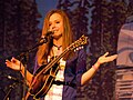
Sierra Dawn Hull (born September 27, 1991) is an American bluegrass singer-songwriter, mandolinist, and guitarist. Hull was signed to Rounder Records at...
21 KB (1,204 words) - 16:54, 1 November 2023