
known as the Velarde map, is a map of the Philippines made and first published in Manila in 1734 by the Jesuit cartographer Pedro Murillo Velarde [es], the...
17 KB (1,648 words) - 15:21, 4 January 2025
up Velarde in Wiktionary, the free dictionary. Velarde may refer to: Velarde, New Mexico Velarde CF, Spanish football team Velarde map, a 1734 map of...
1 KB (207 words) - 21:53, 27 August 2021

the Philippines through the Treaty of Washington in 1900 via the 1734 Velarde map, as well as by the People's Republic of China and the Republic of China...
89 KB (9,846 words) - 12:59, 21 April 2025
the 1734 Murillo Velarde map, regarded as "The Mother of All Philippine Maps," through an auction at Sotheby's London in 2014. The map served as critical...
11 KB (1,078 words) - 23:43, 31 December 2024

Spratly Islands (category Articles containing OSM location maps)
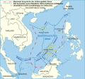
Bajos de Paragua" off the coast of Palawan (Paragua) on the Velarde map An 1801 Cary Map of the East Indies and Southeast Asia showing Panacot, the Scarborough...
120 KB (11,819 words) - 11:02, 19 May 2025

Nine-dash line (redirect from Nine-dash map)
Retrieved 18 November 2018. Jadloc, M. (October 2018). Map Rights Wrong: The 1734 Murillo Velarde Map. Update Journal Volume 1-2 Number 1. STRATFOR's Global...
58 KB (5,751 words) - 14:11, 15 April 2025
cartographer; see Archaeology of the Philippines Velarde map or Murillo Velarde map, a historical map of the Philippines This disambiguation page lists...
301 bytes (66 words) - 06:08, 28 October 2020

24 hours of release and was praised for its depiction of the Murillo–Velarde map of the Philippines, while the video for "Bazinga", directed by Jonathan...
107 KB (5,557 words) - 14:34, 17 May 2025

"Dapyto" in Sanson's map of 1652 and "Dapitan" which can be found in Moll's map of the East Indies, 1729 and in Murillo Velarde's map of 1734. After Legazpi's...
72 KB (6,426 words) - 06:16, 13 May 2025

[lit. 'chico'] tributary or Itabes (Itawis) river meet." In the Murillo Velarde Map (1734), towns in the area are identified as "Gatara" and "Nasipin". The...
20 KB (1,477 words) - 22:35, 11 April 2025
Spratly Islands dispute (category Articles containing OSM location maps)
referred as the Velarde map) was published by the Spanish colonial government. According to Philippine judge Antonio Carpio, the map shows Philippine...
129 KB (11,890 words) - 16:44, 4 May 2025
War Artifacts Boxer Codex Doctrina Christiana UST Baybayin Documents Velarde map American colonial period (1898–1946) Tagalog Republic Negros Republic...
12 KB (1,034 words) - 12:58, 9 March 2025

municipality on July 25, 1569. Based on the 1734 Murillo Velarde map, one of the earliest cartographic maps of the Philippine archipelago, the town is identified...
39 KB (4,252 words) - 10:28, 18 May 2025

War Artifacts Boxer Codex Doctrina Christiana UST Baybayin Documents Velarde map American colonial period (1898–1946) Tagalog Republic Negros Republic...
60 KB (4,759 words) - 17:08, 21 April 2025
Christ, or the saints) to spread Roman Catholicism. Maps were also printed, including the 1734 Velarde map. Printmaking has diversified to include woodblock...
179 KB (15,739 words) - 04:11, 16 May 2025

blessings from the Almighty for a significant "end". In 17th century map Murillo-Velarde Map it somewhat appears as Dijolongan. Three barrios were created in...
22 KB (1,394 words) - 09:12, 15 May 2025
Territorial disputes in the South China Sea (category Articles containing OSM location maps)
depictions from the Velarde map. According to retired Philippine Supreme Court justice Antonio Carpio, territories in these maps fell under the sovereignty...
175 KB (16,941 words) - 21:16, 8 April 2025
War Artifacts Boxer Codex Doctrina Christiana UST Baybayin Documents Velarde map American colonial period (1898–1946) Tagalog Republic Negros Republic...
12 KB (1,306 words) - 02:39, 16 March 2025

December 19, 2019. Analyn Perez (November 25, 2009). "The Ampatuan Massacre: a map and timeline". GMA News. Archived from the original on February 15, 2015...
76 KB (5,788 words) - 09:20, 1 May 2025
War Artifacts Boxer Codex Doctrina Christiana UST Baybayin Documents Velarde map American colonial period (1898–1946) Tagalog Republic Negros Republic...
26 KB (2,322 words) - 03:13, 9 April 2025

Pinatubo; Tagalog: Bundok/Bulkang Pinatubo IPA: [pɪ.nɐˈtuː.boʔ] "Tarlac map". University of Texas in Austin Library. Archived from the original on July...
43 KB (4,445 words) - 12:45, 7 April 2025

War Artifacts Boxer Codex Doctrina Christiana UST Baybayin Documents Velarde map American colonial period (1898–1946) Tagalog Republic Negros Republic...
10 KB (740 words) - 05:57, 12 March 2025

where it can fish and exploit offshore oil and gas, also citing the Velarde map as reference. He also expressed a wish to form partnerships with other...
187 KB (16,298 words) - 02:30, 18 May 2025

Detail from the Murillo Velarde map (c.1734) of the Philippines, showing an areca palm with fruits, captioned Bongas con que se hace el buyo de que usa...
67 KB (7,495 words) - 02:27, 6 May 2025

War Artifacts Boxer Codex Doctrina Christiana UST Baybayin Documents Velarde map American colonial period (1898–1946) Tagalog Republic Negros Republic...
79 KB (7,928 words) - 17:13, 14 May 2025

War Artifacts Boxer Codex Doctrina Christiana UST Baybayin Documents Velarde map American colonial period (1898–1946) Tagalog Republic Negros Republic...
100 KB (10,893 words) - 20:07, 5 May 2025

colonial government published the first edition of the Velarde map. According to the Philippines, this map shows the territories of the Philippines including...
108 KB (11,043 words) - 20:46, 6 May 2025

War Artifacts Boxer Codex Doctrina Christiana UST Baybayin Documents Velarde map American colonial period (1898–1946) Tagalog Republic Negros Republic...
108 KB (11,115 words) - 09:15, 17 May 2025

The Murillo Velarde Map (Carta Hydrographica y Chorographica de las Yslas Filipinas Dedicada al Rey Nuestro Señor por el Mariscal d. Campo D. Fernando...
33 KB (3,250 words) - 10:42, 27 March 2025
War Artifacts Boxer Codex Doctrina Christiana UST Baybayin Documents Velarde map American colonial period (1898–1946) Tagalog Republic Negros Republic...
9 KB (203 words) - 20:21, 7 May 2025