
The Advanced Spaceborne Thermal Emission and Reflection Radiometer (ASTER) is a Japanese remote sensing instrument onboard the Terra satellite launched...
13 KB (1,082 words) - 21:33, 9 February 2025

processes, and the alteration of minerals by surface and/or subsurface water. The Advanced Spaceborne Thermal Emission and Reflection Radiometer (ASTER)...
15 KB (1,610 words) - 18:39, 7 April 2024

acquires thermal data in two 10 and 11 bands from Thermal Infrared Sensor (TIRS). Advanced Spaceborne Thermal Emission and Reflection Radiometer (ASTER)...
13 KB (1,276 words) - 20:01, 22 May 2025
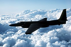
Lockheed U-2 (section Pilot selection and training)
Resolution Imaging Spectroradiometer (MODIS) and Advanced Spaceborne Thermal Emission and Reflection Radiometer (ASTER) satellite instruments. In 2020, the...
168 KB (20,244 words) - 18:44, 8 August 2025

NASA WorldWind (section Add-ons and plugins)
(SRTM), National Elevation Dataset (NED) and Advanced Spaceborne Thermal Emission and Reflection Radiometer (ASTER). This means one can view topographic...
20 KB (2,027 words) - 15:04, 1 November 2024

Earth's environment and ongoing changes in its climate system: ASTER (Advanced Spaceborne Thermal Emission and Reflection Radiometer) ASTER creates high-resolution...
12 KB (1,035 words) - 17:22, 30 July 2025

Digital elevation model (category Geographic data and information)
Mission (SRTM, 2000) using single-pass SAR and the Advanced Spaceborne Thermal Emission and Reflection Radiometer (ASTER, 2000) instrumentation on the Terra...
32 KB (3,353 words) - 16:34, 22 July 2025
elevation. Shuttle Radar Topography Mission Advanced Spaceborne Thermal Emission and Reflection Radiometer USGS EROS Archive - Digital Elevation - Global...
6 KB (128 words) - 21:28, 14 September 2023

VNIR (redirect from Visible and near-infrared)
working on the spectral range of VNIR. Advanced Spaceborne Thermal Emission and Reflection Radiometer Airborne Real-time Cueing Hyperspectral Enhanced...
3 KB (316 words) - 09:11, 12 May 2023
Aerial archaeology (section Thermal imaging)
(advanced spaceborne thermal emission and reflection radiometer) is used to create maps of "land surface temperature, reflectance, and elevation." It is attached...
38 KB (4,661 words) - 20:48, 18 July 2025

rock pile, and an airstrip capable of landing aircraft as large as Boeing 737s and C130 Hercules. The complex also houses processing, power and boiler plants...
11 KB (1,114 words) - 16:22, 5 August 2025

causing widespread damage and loss of life. The deadly landslide (or debris flow) followed a 10-day period of heavy rain and a minor earthquake (magnitude...
18 KB (2,049 words) - 00:41, 9 May 2025

global environmental changes: ASTER (Advanced Spaceborne Thermal Emission and Reflection Radiometer) CERES (Clouds and the Earth's Radiant Energy System)...
15 KB (1,659 words) - 14:46, 19 July 2025

Plume of Icelandic Volcano". NASA. "NASA ASTER (Advanced Spaceborne Thermal Emission and Reflection Radiometer), Volcanology". Archived from the original on...
30 KB (3,433 words) - 13:15, 22 July 2025

Present. Satellite image of Trou au Natron via Advanced Spaceborne Thermal Emission and Reflection Radiometer (ASTER) Satellite image of the Tousside volcano...
7 KB (720 words) - 03:33, 25 June 2025
Ring ditch (category Types of monuments and memorials)
measure and record ring ditches: First, ASTER, Advanced Spaceborne Thermal Emission and Reflection Radiometer, was used in combination with GPS data to help...
6 KB (743 words) - 16:20, 8 August 2024

model National Geospatial-Intelligence Agency Advanced Spaceborne Thermal Emission and Reflection Radiometer SRTM Water Body Data WorldDEM private data with...
21 KB (2,113 words) - 14:45, 20 June 2025

Subglacial lake (section History and expeditions)
to monitor and investigate this lake, including ICESat, CryoSat-2, the Advanced Spaceborne Thermal Emission and Reflection Radiometer, and SPOT5. Gray...
86 KB (9,912 words) - 23:20, 4 August 2025
Imaging Spectroradiometer Advanced Very High Resolution Radiometer Advanced Spaceborne Thermal Emission and Reflection Radiometer Landsat 7 "Satellite Spec"...
12 KB (302 words) - 08:51, 17 March 2025

Iceberg A-38 (section Splitting and movement north)
was grounded (and therefore stationary) high-resolution imagery from the Advanced Spaceborne Thermal Emission and Reflection Radiometer satellite could...
10 KB (1,200 words) - 12:02, 22 April 2025
occurrence of heat waves in Guangdong, China. Advanced Spaceborne Thermal Emission and Reflection Radiometer (ASTER): freely available satellite imagery...
5 KB (492 words) - 14:03, 23 May 2025

lithology with Advanced Spaceborne Thermal Emission and Reflection Radiometer (ASTER) multispectral thermal infrared ‘radiance-at-sensor’ data. Remote...
63 KB (7,134 words) - 14:51, 8 June 2025
Legendre Advanced Composite Materials (journal) Advanced Light Source Advanced Photon Source Advanced Spaceborne Thermal Emission and Reflection Radiometer Advanced...
28 KB (2,896 words) - 06:45, 28 July 2025
Multispectral pattern recognition (section Multispectral imaging using discrete detectors and scanning mirrors)
ImageSat International, Inc. (EROS A1) NASA Terra Advanced Spaceborne Thermal Emission and Reflection Radiometer (ASTER) NASA Terra Multiangle Imaging Spectroradiometer...
13 KB (1,645 words) - 22:39, 19 June 2025
List of GIS data sources (category Geographic data and information)
used in geographic information systems (GIS) and spatial databases for purposes of geospatial analysis and cartographic mapping. This list categorizes...
44 KB (559 words) - 05:15, 10 July 2025