
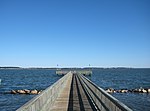
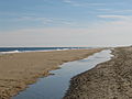
Assateague State Park is a public recreation area in Worcester County, Maryland, located at the north end of Assateague Island, a barrier island bordered...
6 KB (507 words) - 05:52, 1 August 2023

The Maryland section contains the majority of Assateague Island National Seashore and Assateague State Park. The Virginia section contains Chincoteague...
21 KB (1,747 words) - 23:57, 2 May 2024

Assateague Island National Seashore is a unit of the National Park Service system of the U.S. Department of the Interior. Located on the East Coast along...
19 KB (2,361 words) - 10:31, 1 February 2024

Chincoteague pony (redirect from Assateague Pony)
(referred to in the literature of the National Park Service as Assateague horses) live within Assateague Island National Seashore. They are generally treated...
40 KB (4,776 words) - 00:01, 3 May 2024

Maryland, 21811, within walking distance of the Assateague Island Visitor Center at Assateague State Park, Maryland. Built of Flemish bond brick with random...
10 KB (1,080 words) - 18:12, 3 December 2023
This list of Maryland state parks includes the state parks and state battlefields listed in the Maryland Department of Natural Resources's current acreage...
32 KB (193 words) - 05:49, 2 August 2023

Maryland Route 611 (redirect from Maryland State Highway 611)
lot of Assateague State Park on Assateague Island. The state highway immediately intersects Bayberry Road, which is the access road to Assateague Island...
7 KB (744 words) - 20:40, 8 January 2024
The following state parks are within 30 miles (48 km) of Holts Landing State Park: Assateague State Park (Maryland) Cape Henlopen State Park (Sussex County)...
15 KB (1,740 words) - 22:20, 1 August 2023

following state parks are within 30 miles (48 km) of Delaware Seashore State Park: Assateague State Park (Maryland) Cape Henlopen State Park (Sussex County)...
7 KB (638 words) - 22:10, 1 August 2023
Assateague Channel is a channel on the Eastern Shore of Virginia between Chincoteague Island and Assateague Island. The Assateague Channel connects to...
2 KB (202 words) - 15:13, 28 August 2023
National Historic Landmarks by State" (PDF). Archived from the original (PDF) on 2007-06-09. Retrieved 2007-05-20. National Park Service. "National Historic...
40 KB (295 words) - 19:32, 9 February 2024

Eastern Shore of Maryland (redirect from Eastern Shore (proposed state))
intervened before reconstruction by creating the Assateague Island National Seashore and Assateague State Park to preserve this area rather than have it be...
42 KB (3,325 words) - 23:21, 21 February 2024

totaled $30 million. Large swells ahead of the hurricane reached Assateague State Park, Maryland, by September 9, prompting the Maryland Department of...
121 KB (10,490 words) - 07:10, 27 April 2024
following state parks are within 30 miles (48 km) of Fenwick Island State Park: Assateague State Park (Maryland) Cape Henlopen State Park (Sussex County)...
8 KB (830 words) - 15:20, 28 August 2023
original state parks were Seashore State Park (now First Landing State Park), Westmoreland State Park, Staunton River State Park, Douthat State Park, Fairy...
18 KB (235 words) - 20:52, 26 May 2024

Point Lookout State Park is a public recreation area and historic preserve occupying Point Lookout, the southernmost tip of a peninsula formed by the confluence...
17 KB (1,472 words) - 21:58, 25 March 2024

bands bringing rain and gusty winds to the state. Large swells ahead of the hurricane reached Assateague State Park, Maryland, by September 9, prompting the...
77 KB (7,379 words) - 00:27, 23 May 2024
Pocahontas State Park is a state park located in Chesterfield, Virginia, United States, not far from the state capitol of Richmond. The park was laid out...
4 KB (343 words) - 19:06, 15 November 2023

Gwynns Falls/Leakin Park is a park in Baltimore, Maryland. It is the second-largest woodland park in the United States, constituting a contiguous area...
16 KB (1,797 words) - 13:08, 15 February 2024

and bridges in the state, and part of MD 295, also known as the Baltimore–Washington Parkway, is maintained by the National Park Service as a National...
227 KB (556 words) - 04:17, 27 May 2024
north of and directly adjacent to the similarly sized Cunningham Falls State Park. In the 1930s, after years of making charcoal to fuel nearby iron furnaces...
5 KB (448 words) - 03:56, 6 August 2023

Wye Oak (redirect from Wye Oak State Park)
oak tree in the United States and the State Tree of Maryland from 1941 until its demise in 2002. Wye Oak State Park preserves the site where the revered...
11 KB (1,149 words) - 22:51, 28 April 2024

Fish & Wildlife Service. It is primarily located on the Virginia half of Assateague Island with portions (only about 3%) located on the Maryland side of the...
21 KB (2,707 words) - 21:24, 26 July 2023

Hungry Mother State Park is a state park in southwestern Virginia. Much of the land for Hungry Mother State Park was donated by local landowners to develop...
4 KB (299 words) - 10:09, 26 October 2022

Ocean City, Maryland (section Parks and recreation)
thousands of years by Indigenous peoples including the Algonquian-speaking Assateague and Nanticoke peoples. The land on which the city was built and much of...
44 KB (4,125 words) - 12:28, 2 May 2024

It is owned by Maryland, not by the National Park Service. NPS, however, does own part of Assateague Island. Like the larger and more famous Verrazzano-Narrows...
4 KB (210 words) - 00:59, 8 May 2022

Patapsco Valley State Park /pəˈtæpˌskoʊ/ is a Maryland state park extending along 32 miles (51 km) of the Patapsco River south and west of the city of...
17 KB (1,595 words) - 22:15, 30 April 2024

Patterson Park is an urban park in Southeast Baltimore, Maryland, United States, adjacent to the neighborhoods of Canton, Highlandtown, Patterson Park, and...
14 KB (1,415 words) - 12:40, 29 July 2023

Delmarva Peninsula (redirect from Delmarva (proposed state))
the wildlife refuge is administered by the National Park Service as the southern portion of Assateague Island National Seashore. Crisfield, Maryland, is...
38 KB (3,659 words) - 22:49, 23 April 2024

Virginia (redirect from State of Virginia)
forty Virginia state parks and 59,222 acres (239.7 km2) in 65 Natural Area Preserves, plus three undeveloped parks. Breaks Interstate Park crosses the Kentucky...
300 KB (26,631 words) - 14:19, 2 June 2024