
The Center for Land Use Interpretation (CLUI) is a non-profit research and education organization involved in exploring, examining, and understanding contemporary...
12 KB (1,099 words) - 09:52, 30 May 2025

(PDF). The Lay of the Land: The Center for Land Use Interpretation Newsletter. Culver City, CA: The Center for Land Use Interpretation: 6–7. Spring 2002....
12 KB (1,071 words) - 15:55, 27 May 2025
article Center for Land Use Interpretation article about the origins and accuracy of the marker Roadside America article USGS information The Center of the...
11 KB (1,292 words) - 17:14, 27 May 2025

detonated, and nuclear power plants. In the United States, the Center for Land Use Interpretation has conducted tours of the Nevada Test Site, Trinity Site...
18 KB (1,754 words) - 08:32, 16 April 2025
"Warrenton Training Center Site D, Virginia". Center for Land Use Interpretation. Retrieved February 8, 2021. Warrenton Training Center Station B description...
22 KB (2,003 words) - 02:41, 14 January 2025

Observatoire du Land Art (in German) Using land art as a form of advertising Center for Land Use Interpretation entry for Land Art The Case for Land Art | The...
21 KB (2,418 words) - 14:34, 17 April 2025
Mel's Hole (category Use mdy dates from September 2022)
Deen, Paul Laffoley, The Firesign Theatre, Gary Panter, The Center for Land Use Interpretation, James Hayward, Cathy Ward, Eric Wright and Craig Stecyk....
9 KB (920 words) - 12:17, 23 April 2025

Bishop Castle (category Pages using gadget WikiMiniAtlas)
History, photos and status as of June 2007 Entry at the Center for Land Use Interpretation Entry for Bishop Castle at the National Scenic Byways website Portals:...
13 KB (1,109 words) - 23:18, 24 March 2025
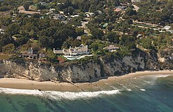
California Coastal Records Project (section Uses)
6 May 2012. "The California Coastal Records Project". The Center for Land Use Interpretation. Spring 2003. Retrieved 2024-01-29. California coast & ocean...
7 KB (649 words) - 15:51, 18 March 2025

Zzyzx, California (category Use mdy dates from January 2025)
System: Zzyzx Spring Zzyzx photos and historical information Center for Land Use Interpretation site page with directions, details, photos, and map link Miech...
12 KB (1,060 words) - 13:00, 4 February 2025

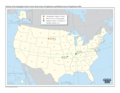
Angle Inlet, Minnesota (category Use mdy dates from July 2023)
United Divide: A Linear Portrait of the USA/Canada Border. The Center for Land Use Interpretation. Winter 2015. "Census of Population and Housing". Census.gov...
10 KB (413 words) - 06:03, 11 May 2025

Drop City (category Pages using gadget WikiMiniAtlas)
the Land: The Center for Land Use Interpretation Newsletter. Culver City, CA, US: Center for Land Use Interpretation. Summer 1996. OCLC 728045237. Archived...
15 KB (1,242 words) - 14:46, 24 February 2025
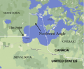
Northwest Angle (category Use mdy dates from July 2023)
USA/Canada Border. The Center for Land Use Interpretation. Winter 2015. "JIM'S CORNER, MINNESOTA". The Center for Land Use Interpretation. Winter 2020. Radil...
26 KB (2,783 words) - 13:50, 14 May 2025

California Men's Colony (category Pages using gadget WikiMiniAtlas)
California Department of Corrections Center for Land Use Interpretation. California Men's Colony. Entry in Land Use Database of "unusual and exemplary sites...
17 KB (1,985 words) - 01:37, 28 January 2025

Lubec, Maine (category Use mdy dates from January 2025)
United Divide: A Linear Portrait of the USA/Canada Border. The Center for Land Use Interpretation. Winter 2015. Cox, Tim (June 11, 2014). "Bay of Fundy International...
19 KB (1,511 words) - 00:09, 4 May 2025

The Center for Land Use Interpretation. Retrieved 2012-10-09. "Fifth Principal Meridian". The Center for Land use Interpretation. Retrieved 2012-10-09....
4 KB (459 words) - 01:19, 3 December 2023

Lima Army Tank Plant (redirect from Joint Systems Manufacturing Center)
Press Release, Closing of Detroit Arsenal Tank Plant. "The Center for Land Use Interpretation". clui.org. Archived from the original on 6 June 2011. Retrieved...
11 KB (1,156 words) - 04:09, 25 May 2024

California State Prison, Corcoran (category Pages using gadget WikiMiniAtlas)
official CDCR webpage Corcoran State Prison[usurped] at the Center for Land Use Interpretation California Department of Corrections and Rehabilitation Official...
25 KB (2,562 words) - 17:31, 20 April 2025

Great Lakes (category Use mdy dates from March 2024)
United Divide: A Linear Portrait of the USA/Canada Border. The Center for Land Use Interpretation. Winter 2015. "Great Lake Seaway Cargoes – American Great...
118 KB (12,428 words) - 14:20, 14 May 2025

Information System: Cathedral Canyon "Cathedral Canyon". Center for Land Use Interpretation. Retrieved May 12, 2022. Burrud, Bill. Queho's Secret Hideout...
8 KB (721 words) - 06:25, 7 April 2025

United Divide: A Linear Portrait of the USA/Canada Border. The Center for Land Use Interpretation. Winter 2015. Irish border photos show how invisible line...
5 KB (365 words) - 04:35, 30 April 2025

Point Roberts, Washington (category Use American English from April 2025)
United Divide: A Linear Portrait of the USA/Canada Border. The Center for Land Use Interpretation. Winter 2015. Archived from the original on November 14, 2017...
49 KB (4,838 words) - 05:36, 21 May 2025

One Wilshire (category Use American English from May 2023)
began One Wilshire's importance as a telecom site. — The Center for Land Use Interpretation, 2013 In 1992, One Wilshire underwent a major renovation,...
19 KB (1,535 words) - 15:30, 15 May 2025
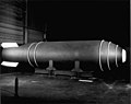
the area. A marker was placed on the site in 1996 by the Center for Land Use Interpretation, but it was later removed. Five MK 17/24 casings are on display...
9 KB (900 words) - 14:31, 20 May 2025

Whitefish Point (category Pages using gadget WikiMiniAtlas)
United Divide: A Linear Portrait of the USA/Canada Border. The Center for Land Use Interpretation. Winter 2015. Stonehouse, Frederick (1985, 1998). Lake Superior’s...
7 KB (341 words) - 05:46, 11 December 2024
Border irregularities of the United States (category Pages using gadget WikiMiniAtlas)
United Divide: A Linear Portrait of the USA/Canada Border. The Center for Land Use Interpretation. Winter 2015. Archived from the original on 2018-12-10. Retrieved...
18 KB (2,176 words) - 19:21, 28 May 2025

Richard J. Donovan Correctional Facility (category Use mdy dates from April 2023)
September 24, 2011. "Otay Mesa Prison Area, California". The Center for Land Use Interpretation. Retrieved April 15, 2018. "California Department of Corrections...
27 KB (2,184 words) - 03:02, 14 May 2025

Derby Line, Vermont (category Use mdy dates from May 2024)
United Divide: A Linear Portrait of the USA/Canada Border. The Center for Land Use Interpretation. Winter 2015. "History of Butterfield's". The Stanstead Journal...
19 KB (1,292 words) - 03:59, 10 May 2025

Haskell Free Library and Opera House (category Use mdy dates from February 2025)
United Divide: A Linear Portrait of the USA/Canada Border. The Center for Land Use Interpretation. Winter 2015. "Haskell Free Library and Opera House". Alpine...
17 KB (1,686 words) - 21:52, 30 May 2025

Thousand Islands Bridge (category Use mdy dates from January 2025)
United Divide: A Linear Portrait of the USA/Canada Border. The Center for Land Use Interpretation. Winter 2015. "Ground Is Broken On Site Of Bridge Over St...
12 KB (892 words) - 15:01, 13 May 2025