The Canadian province of British Columbia has a system of numbered highways that travel between various cities and regions with onward connections to...
94 KB (1,333 words) - 10:43, 20 August 2024
Highway 1 is a provincial highway in British Columbia, Canada, that carries the main route of the Trans-Canada Highway (TCH). The highway is 1,047 kilometres...
71 KB (3,894 words) - 02:36, 14 September 2024
Highway 99 is a provincial highway in British Columbia that runs 377 kilometres (234 mi) from the U.S. border to near Cache Creek, serving Greater Vancouver...
100 KB (8,919 words) - 00:23, 16 September 2024
Highway 5 is a 543 km (337 mi) north–south route in southern British Columbia, Canada. Highway 5 connects the southern Trans-Canada route (Highway 1) with...
37 KB (2,910 words) - 15:54, 25 July 2024

with a higher proportion of gravel surfaces Alberta's 1 to 216 series of provincial highways are Alberta's main highways. They are numbered from 1 to...
157 KB (1,036 words) - 15:50, 30 August 2024
south to north: List of British Columbia provincial highways Landmark Kilometre Inventory (PDF). British Columbia Ministry of Transportation and Infrastructure...
11 KB (684 words) - 17:16, 29 March 2023
Highway 16 is a highway in British Columbia, Canada. It is an important section of the Yellowhead Highway, a part of the Trans-Canada Highway that runs...
25 KB (1,876 words) - 20:00, 4 September 2024
north: Roads portal List of British Columbia provincial highways Landmark Kilometre Inventory (PDF). British Columbia Ministry of Transportation and Infrastructure...
10 KB (645 words) - 22:55, 22 September 2022
Highway 91 is an alternative freeway route to Highway 99 through Delta, New Westminster and Richmond, British Columbia. The highway was built in two sections...
20 KB (1,378 words) - 00:31, 27 August 2024
The British Columbia Provincial Police (BCPP) was the provincial police service of British Columbia, Canada, between 1858 and 1950. One of the first law...
19 KB (2,408 words) - 07:33, 1 May 2024

construction of high-mobility alternative routes or bypasses. The building and maintenance of provincial highways is the responsibility of the British Columbia Ministry...
175 KB (15,820 words) - 04:58, 19 September 2024

The premier of British Columbia is the first minister for the Canadian province of British Columbia. The province was a British crown colony governed...
35 KB (634 words) - 02:29, 19 September 2024

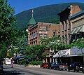
the Canadian province of British Columbia, located at the north end of Howe Sound on the Sea to Sky Highway. The population of the Squamish census agglomeration...
46 KB (2,759 words) - 00:11, 12 July 2024
Arm of Kootenay Lake in the Southern Interior of British Columbia, Canada. Known as "The Queen City" and acknowledged for its impressive collection of restored...
35 KB (2,738 words) - 23:00, 1 August 2024
This is a list of Saskatchewan's highways: Only Highways 1, 2, 5, 6, 7, 11, 12, 16, and 39 contain sections of divided highway. Speed limits range from...
112 KB (550 words) - 20:34, 6 February 2024

Crowsnest Highway is an east-west highway in British Columbia and Alberta, Canada. It stretches 1,161 km (721 mi) across the southern portions of both provinces...
21 KB (1,527 words) - 05:40, 27 August 2024
of the Southern Interior of British Columbia, Canada. It is 440 km (270 mi) northeast of Vancouver. Named after Forbes George Vernon, a former MLA of...
59 KB (4,786 words) - 21:04, 20 September 2024

city in British Columbia, Canada. It is located south of the Fraser River on the Canada–United States border. It is a member municipality of the Metro...
101 KB (7,471 words) - 02:41, 19 August 2024
Highway 17 is a provincial highway in British Columbia, Canada. It comprises two separate sections connected by a ferry link. The Vancouver Island section...
32 KB (2,264 words) - 03:08, 29 February 2024

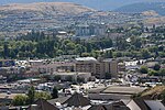
KRAN-bruuk) is a city in southeast British Columbia, Canada, located approximately 10 km southwest of the confluence of the Kootenay River and the St. Mary's...
37 KB (2,133 words) - 16:06, 14 August 2024
BC United (redirect from Liberal Party of British Columbia (BC Liberals Party))
known until 2023 as the British Columbia Liberal Party or BC Liberals, is a provincial political party in British Columbia, Canada. On August 28, 2024...
63 KB (6,004 words) - 15:28, 14 September 2024
This list consists of decomissioned or retired highways that have since been replaced with newer highways within Alberta's provincial highway network....
59 KB (998 words) - 09:39, 31 August 2024
east; list excludes United Boulevard. The entire route is in Metro Vancouver. Landmark Kilometre Inventory (PDF). British Columbia Ministry of Transportation...
8 KB (731 words) - 23:20, 10 May 2023

sign British Columbia sign along Klondike Highway List of Alaska Routes List of British Columbia provincial highways List of Yukon territorial highways Overland...
11 KB (864 words) - 03:47, 21 August 2024

Roads in Canada (redirect from Highways in Canada)
There are many classes of roads in Canada. The only inter-provincial systems are the Trans-Canada Highway and National Highway System. County roads in...
2 KB (58 words) - 18:41, 29 July 2024

of British Columbia, Canada. Located nearly evenly between the cities of Prince George and Williams Lake, it is on the main route to northern British...
42 KB (2,349 words) - 23:52, 9 July 2024

the West Kootenay region of British Columbia, Canada. In the Selkirk Mountains, at the confluence of the Kootenay and Columbia Rivers, it is a regional...
24 KB (1,908 words) - 16:52, 16 September 2024

Vancouver Island in the province of British Columbia, Canada. Langford is one of the 13 component municipalities of Greater Victoria and is within the...
33 KB (2,478 words) - 01:33, 17 August 2024

a village of about 250 residents in southern British Columbia, Canada, on the east side of the Fraser River and primarily the south side of the Thompson...
38 KB (2,856 words) - 15:22, 26 August 2024

Armstrong, officially the City of Armstrong is a city in the North Okanagan of the Canadian province of British Columbia, between Vernon and Enderby. It...
27 KB (1,667 words) - 02:18, 24 July 2024