
Ireland Motorways in the Republic of Ireland History of roads in Ireland Trunk roads in Ireland Transport in Ireland "Local Government (Roads and Motorways)...
6 KB (767 words) - 14:45, 23 March 2025

of roads in Ireland are allocated blocks of numbers so that no number is used more than once save in the case of local primary roads. Not all road numbers...
30 KB (3,606 words) - 17:53, 22 May 2025

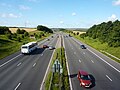
trackways in Ireland connecting settlements and facilitating trade since ancient times and the country now has an extensive network of public roads connecting...
77 KB (8,959 words) - 18:27, 13 January 2025

The main roads in Northern Ireland are signed "M"/"A"/"B" as in Great Britain. Whereas the roads in Great Britain are numbered according to a zonal system...
8 KB (544 words) - 04:47, 25 March 2025

link road. Trunk and link roads were identified by numbers prefixed with the letter T or L respectively; lesser roads had no such identifiers. In 1977...
35 KB (1,554 words) - 20:44, 22 May 2025

The functions of local government in the Republic of Ireland are mostly exercised by thirty-one local authorities, termed County, City, or City and County...
28 KB (2,421 words) - 17:08, 2 May 2025
Local government in Northern Ireland is divided among 11 single-tier districts known as 'Local Government Districts' (abbreviated LGDs) and formerly known...
166 KB (1,944 words) - 18:30, 28 January 2025

bypassed former N11. Roads in Ireland National primary road National secondary road Roads Act 1993 (Classification of Regional Roads) Order 2019 – Department...
4 KB (363 words) - 18:22, 2 June 2023

maintenance, creating a hierarchy from national to local roads. Design type classification groups roads by geometric and operational characteristics, such...
44 KB (4,349 words) - 14:34, 8 May 2025
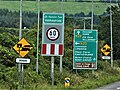
Road signs in Ireland do not differ greatly from those used elsewhere in Europe – with the notable exception that hazard or warning signs follow the 'MUTCD'...
54 KB (5,586 words) - 15:04, 27 May 2025

one of the longest regional roads in Ireland (longer than most national roads). Indeed, much of the route comprises roads that were formerly part of the...
13 KB (1,244 words) - 07:40, 8 September 2023

Secondary Roads, all existing Regional Roads and all existing Local Roads radiating from the town. The consequent benefit will be a reduction in traffic...
5 KB (492 words) - 03:40, 14 April 2025
public roads in Ireland. The alphanumeric marks (or "registration numbers", officially termed "identification marks") themselves are issued by the local authority...
57 KB (6,135 words) - 21:14, 13 May 2025
county council or unitary authority. In Northern Ireland, DfI Roads is responsible for all 5,592 miles (8,999 km) roads. The pan-UK total is 15,260 miles...
71 KB (7,445 words) - 16:05, 10 March 2025

black on white as on local roads. National primary & secondary roads. Route numbers are written in yellow. Regional & local roads On non-motorways only...
299 KB (2,993 words) - 08:29, 28 May 2025
Rocky Road To Dublin The song performed by Christoph Nolte. Problems playing this file? See media help. "Rocky Road to Dublin" is a 19th-century Irish song...
15 KB (1,151 words) - 07:32, 29 May 2025

Reform of local government in Northern Ireland saw the replacement of the twenty-six districts created in 1973 with a smaller number of "super districts"...
21 KB (1,682 words) - 23:39, 3 October 2024

Springfield Road (Irish: Bóthar Chluanaí) is a residential area and road traffic thoroughfare adjacent to the Falls Road in west Belfast. The local population...
30 KB (3,667 words) - 21:28, 19 April 2025

Military Road by John Godden. Retrieved: 2011-12-04. Statutory Instrument 54 of 2012 — Roads Act 1993 (Classification of Regional Roads) Order 2012, Irish Statute...
8 KB (707 words) - 09:07, 6 November 2024
motorway at Kilbeggan. Roads in Ireland Motorways in Ireland National primary road Regional road N80 Mountmellick Inner Relief Road N52 Tullamore Bypass...
5 KB (394 words) - 01:46, 10 August 2023
Cavan and the border with County Fermanagh. The A509 and A46 roads in Northern Ireland form part of an overall route connecting to Enniskillen, and northwest...
16 KB (1,322 words) - 18:40, 22 May 2025

that established a system of local government in Ireland similar to that already created for England and Wales by the Local Government Act 1888 (51 & 52...
30 KB (3,308 words) - 19:48, 1 May 2025

limits in Ireland apply on all public roads in the state. These are regulated in the Road Traffic Act 2004, and are signposted and legislated for in kilometres...
18 KB (2,255 words) - 21:46, 23 May 2025

primary roads and national secondary roads are managed by Transport Infrastructure Ireland, while regional roads and local roads are managed by the local authorities...
224 KB (19,874 words) - 14:49, 16 May 2025

sub-schemes in use: one for motorways, and another for non-motorway roads. While some of Great Britain's major roads form part of the international E-road network...
24 KB (2,992 words) - 17:45, 18 May 2025
National Roads Authority, local authorities, and the Health Service Executive, these are not factored into RSA statistics. The RSA defines a road traffic...
22 KB (1,226 words) - 10:09, 23 April 2025
Griffith Avenue all in the city of Dublin. Roads in Ireland National primary road National secondary road Regional road Map of first section of R102, Google...
4 KB (363 words) - 16:18, 22 August 2024

The R629 road is a regional road in southeast County Cork, Ireland. It travels from the R630 road at Ballinacurra's grotto, southeastwards through Kearney's...
3 KB (160 words) - 12:26, 17 February 2023

Local elections were held in Northern Ireland on 18 May 2023. The elections were delayed by two weeks to avoid overlapping with the coronation of King...
166 KB (1,318 words) - 23:51, 29 April 2025

The R630 road is a regional road in southeast County Cork, Ireland. It travels from the R907 road at Midleton's Youghal Road, southwards through Ballinacurra...
3 KB (164 words) - 21:09, 22 October 2024