
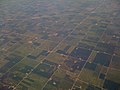
The Public Land Survey System (PLSS) is the surveying method developed and used in the United States to plat, or divide, real property for sale and settling...
53 KB (6,035 words) - 14:29, 7 June 2025
the layout of the Public Land Survey System used in the United States, but has several differences. The DLS is the dominant survey method in the Prairie...
27 KB (3,570 words) - 20:34, 21 May 2025
Spanish land grants, does not use the Public Land Survey System (also known as the Section Township Range and the Jeffersonian System). Land grants from...
4 KB (548 words) - 20:13, 23 August 2024

A survey township, sometimes called a Congressional township or just township, as used by the United States Public Land Survey System and by Canada's...
6 KB (642 words) - 11:20, 2 October 2024

In U.S. land surveying under the Public Land Survey System (PLSS), a section is an area nominally one square mile (2.6 square kilometers), containing 640...
13 KB (1,656 words) - 03:12, 23 May 2025
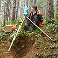
Surveying or land surveying is the technique, profession, art, and science of determining the terrestrial two-dimensional or three-dimensional positions...
57 KB (7,282 words) - 07:24, 12 March 2025
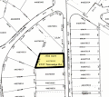
The lot and block survey system is a method used in the United States and Canada to locate and identify land, particularly for lots in densely populated...
6 KB (890 words) - 04:23, 2 June 2025

Homestead Act of 1862. The Land Ordinance established the basis for the Public Land Survey System. The initial surveying was performed by Thomas Hutchins...
30 KB (3,817 words) - 02:34, 6 June 2025
Geodesy Public Land Survey System, the method of determining township boundaries in the USA Construction engineering, a primary use of Land Survey products...
718 bytes (118 words) - 05:50, 16 October 2018
enactment of the Land Ordinance of 1785, which created the Public Land Survey System, the Treasury Department had already overseen the survey of the Northwest...
10 KB (939 words) - 00:46, 18 August 2024

Genesee Township, Michigan (section Public facilities)
Genesee County in the U.S. state of Michigan. In the Public Land Survey System, the township is survey area township 8 north, range 7 east. The population...
14 KB (1,434 words) - 19:54, 21 May 2025

Surveying in North America is heavily influenced by the United States Public lands survey system. It inherits the basis of its land tenure from the United...
7 KB (855 words) - 20:07, 21 February 2024

divided into 640-acre numbered sections (260 ha) according to the Public Land Survey System; odd-numbered plots were given to private railroad companies,...
10 KB (1,084 words) - 02:59, 2 June 2025

Real property (redirect from Land for sale)
recorded in the files of the County Engineer). The Public Land Survey System (PLSS) is the surveying method developed and used in the United States to...
26 KB (3,637 words) - 18:26, 22 May 2025

right down to the present day. Category:Historic surveying landmarks in the United States Public Land Survey System Washington as Public Land Surveyor...
7 KB (953 words) - 19:32, 9 February 2025

surveys in Wisconsin and northeastern Minnesota. It is part of the Public Land Survey System that covers most of the United States. The fourth principal meridian...
6 KB (572 words) - 14:14, 1 February 2025
no other land survey system (such as the US Public Land Survey System), parcels are the most reliable way to describe a particular area of land. This is...
3 KB (350 words) - 17:03, 18 November 2022
Badger Township, Polk County, Minnesota (section Native land cessions and incorporation into United States territory)
Metropolitan Statistical Area. Under the United States Public Land Survey System it is a survey township identified as Township 149 North, Range 42 West...
19 KB (2,250 words) - 23:49, 9 September 2023
Line and Meridian, Arizona Mason and Dixon Survey Terminal Point, West Virginia Public Land Survey System List of principal and guide meridians and base...
4 KB (459 words) - 01:19, 3 December 2023
Cadastre (redirect from Cadastral land surveys)
survey information is often a base element in Geographic Information Systems (GIS) or Land Information Systems (LIS) used to assess and manage land and...
20 KB (2,258 words) - 01:27, 26 May 2025
follows the original survey route marked by Augustus Jones after the Between the Lakes Purchase in 1792. Public Land Survey System (United States) List...
6 KB (724 words) - 18:13, 19 February 2025
The Boise meridian is one of the 35 principal meridians of the Public Land Survey System of the United States. Adopted in 1867, its longitude is 116° 23′...
3 KB (265 words) - 14:22, 1 February 2025
established the basis for the Public Land Survey System. The Land Ordinance of 1785 provided a method for settling that land and establishing government...
17 KB (2,008 words) - 18:02, 11 February 2025
of 400 sq mi, but is not 20 miles square. In the United States Public Land Survey System, "square mile" is an informal synonym for section. Rowlett, Russ...
4 KB (247 words) - 12:13, 12 May 2025
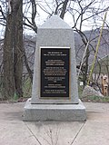
Beginning Point of the U.S. Public Land Survey is the point from which the United States in 1786 began the formal survey of the lands known then as the...
6 KB (587 words) - 17:27, 13 January 2025
Red River Rebellion (category Surveying of Canada)
the land according to the square township system used in the Public Land Survey System. The Métis, led by Riel, prevented McDougall from entering the...
39 KB (4,302 words) - 02:59, 27 May 2025
townships are divided into a 6-by-6 grid of 36 sections. In the U.S. Public Land Survey System, Section 1 of a township is in the northeast corner, and the numbering...
13 KB (1,372 words) - 17:23, 25 May 2025

Diablo in California at W 121° 54.845. Established under the U.S. Public Land Survey System, it is used to describe lands in most of northern California and...
2 KB (182 words) - 14:17, 1 February 2025
Land surveying in Kentucky is the practice of land surveying in the Commonwealth of Kentucky. Boundary Survey: In this type of survey, property corners...
9 KB (944 words) - 22:39, 23 September 2024

Seven Ranges (category Surveying of the United States)
Seven Ranges) was a land tract in eastern Ohio that was the first tract to be surveyed in what became the Public Land Survey System. The tract is 42 miles...
15 KB (1,820 words) - 02:34, 9 January 2024