Satellite navigation solution for the receiver's position (geopositioning) involves an algorithm. In essence, a GNSS receiver measures the transmitting...
13 KB (1,920 words) - 11:40, 2 January 2025

A satellite navigation or satnav system is a system that uses satellites to provide autonomous geopositioning. A satellite navigation system with global...
45 KB (4,560 words) - 11:19, 28 May 2025
The Global Positioning System (GPS) is a satellite-based hyperbolic navigation system owned by the United States Space Force and operated by Mission Delta...
184 KB (19,110 words) - 08:39, 20 June 2025

A satellite navigation (satnav) device or GPS device is a device that uses satellites of the Global Positioning System (GPS) or similar global navigation...
39 KB (4,142 words) - 23:23, 17 April 2025
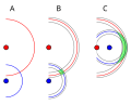
term used in satellite navigation and geomatics engineering to specify the error propagation as a mathematical effect of navigation satellite geometry on...
16 KB (2,224 words) - 18:22, 1 July 2024

BeiDou (redirect from Beidou satellite navigation system)
The BeiDou Navigation Satellite System (BDS; Chinese: 北斗卫星导航系统; pinyin: běidǒu wèixīng dǎoháng xìtǒng) is a satellite-based radio navigation system owned...
68 KB (5,866 words) - 01:18, 2 June 2025
Galileo is a global navigation satellite system (GNSS) created by the European Union through the European Space Agency (ESA) and operated by the European...
104 KB (10,186 words) - 08:22, 4 June 2025
Time to first fix (category Satellite navigation)
time required for a GPS navigation device to acquire satellite signals and navigation data, and calculate a position solution (called a fix). The TTFF...
4 KB (427 words) - 14:53, 18 August 2024

military satellite is an artificial satellite used for a military purpose. The most common missions are intelligence gathering, navigation and military...
17 KB (1,612 words) - 19:49, 13 June 2025
World Geodetic System (category Navigation)
Geodetic System (WGS) is a standard used in cartography, geodesy, and satellite navigation including GPS. The current version, WGS 84, defines an Earth-centered...
24 KB (2,842 words) - 03:41, 26 April 2025
GNSS augmentation (redirect from Satellite navigation augmentation system)
Augmentation of a global navigation satellite system (GNSS) is a method of improving the navigation system's attributes, such as precision, reliability...
15 KB (1,588 words) - 13:54, 20 April 2025
Automotive navigation system Marine navigation systems using sonar Satellite navigation system Global Positioning System, a group of satellites and computers...
5 KB (551 words) - 12:16, 9 October 2024

Galileo and GLONASS constellations for navigation and geodesy in MEO, the Iridium and Globalstar satellite telephony services and Orbcomm messaging...
25 KB (1,737 words) - 10:21, 3 June 2025
technology and navigation services. A chosen solution would be the most cost-effective for the civil aviation authority, as opposed to a solution being established...
18 KB (2,433 words) - 04:44, 6 March 2024

Michibiki (みちびき, "guidance"), is a four-satellite regional satellite navigation system and a satellite-based augmentation system developed by the Japanese government...
23 KB (1,908 words) - 01:40, 26 February 2025

needed] Satellite navigation systems send several signals that are used to decode the satellite's position, distance between the user satellite, and the...
40 KB (5,315 words) - 22:23, 16 January 2025
Trimble Inc. (redirect from Trimble Navigation Ltd.)
global navigation satellite system (GNSS) receivers, scanners, total stations, laser rangefinders, unmanned aerial vehicles (UAVs), inertial navigation systems...
8 KB (567 words) - 09:34, 26 March 2025
European satellite navigation system Galileo. The European Satellite Navigation Competition (ESNC) seeks to gather innovative ideas and solutions for commercial...
10 KB (1,113 words) - 19:58, 7 June 2024

CoMaps (category Satellite navigation software)
transparency, and community collaboration, aiming to provide a navigation solution that is not only easy to use, but also respects user data and fosters...
7 KB (566 words) - 12:06, 20 June 2025
key role in the development of the guidance, navigation, and control of the U.S. Navy's Transit satellite system at Johns Hopkins Applied Physics Laboratories...
8 KB (963 words) - 20:16, 27 April 2025
Wide Area Augmentation System (category Satellite-based augmentation systems)
system a satellite-based augmentation system (SBAS). Europe and Asia are developing their own SBASs: the Indian GPS aided GEO augmented navigation (GAGAN)...
42 KB (4,012 words) - 16:26, 17 March 2025

Differential GPS (redirect from Differential satellite navigation)
supplement and enhance the positional data available from global navigation satellite systems (GNSSs). A DGPS can increase accuracy of positional data...
26 KB (2,943 words) - 22:01, 14 April 2025
Iridium Communications (redirect from Iridium satellite)
that approves the use of Iridium for Future Air Navigation System (FANS) data links, enabling satellite data links with air-traffic control for aircraft...
43 KB (3,960 words) - 10:50, 27 May 2025
Receiver autonomous integrity monitoring (category Air navigation)
collected and integrated by the receiver units employed in a Global Navigation Satellite System (GNSS). The integrity of received signals and resulting correctness...
10 KB (1,477 words) - 10:47, 22 February 2024

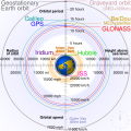
Geostationary orbit (redirect from Geostationary satellite)
located. Weather satellites are also placed in this orbit for real-time monitoring and data collection, as are navigation satellites in order to provide...
49 KB (4,893 words) - 06:24, 20 May 2025
Satellites. BeiDou Navigation Satellite System Signal In Space. China Satellite Navigation Office. December 2013. Access 2 May 2021. O3b satellites Satellite...
10 KB (1,037 words) - 23:27, 10 October 2024

An inertial navigation system (INS; also inertial guidance system, inertial instrument) is a navigation device that uses motion sensors (accelerometers)...
47 KB (5,956 words) - 10:04, 19 June 2025

application of surveying to correct for common errors in current satellite navigation (GNSS) systems. It uses measurements of the phase of the signal's...
12 KB (1,344 words) - 00:31, 11 June 2025

conventional navigation systems, like dead reckoning, to eliminate the incorrect position solution. The first of these hyperbolic navigation systems was...
22 KB (2,818 words) - 08:37, 13 April 2025

Hyperbolic navigation is a class of radio navigation systems in which a navigation receiver instrument is used to determine location based on the difference...
38 KB (5,303 words) - 04:20, 17 June 2025