/ 25.6137°N 80.384°W / 25.6137; -80.384 The Center for Southeastern Tropical Advanced Remote Sensing (CSTARS) is a ground station owned by the University...
8 KB (817 words) - 17:00, 30 May 2024

GOES-3 was decommissioned 29 June 2016 at the Center for Southeastern Tropical Advanced Remote Sensing facility in Miami, Florida. GOES-3 was built by...
9 KB (593 words) - 01:09, 1 November 2024
Rosenstiel School of Marine, Atmospheric, and Earth Science (section Cooperative Institute for Marine and Atmospheric Studies)
Health Center, National Resource for Aplysia, National Center for Coral Reef Research, Center for Southeastern Tropical Advanced Remote Sensing (CSTARS)...
32 KB (2,905 words) - 01:22, 12 June 2025
antenna used for long interferometry. The University of Miami's Rosenstiel School's Center for Southeastern Tropical Advanced Remote Sensing and Richmond...
140 KB (11,759 words) - 03:23, 20 June 2025
processed, 35-year-old Seasat SAR imagery. The Center for Southeastern Tropical Advanced Remote Sensing (CSTARS) downlinks and processes SAR data (as well...
26 KB (3,688 words) - 10:31, 27 March 2025

hunters. These aircraft fly directly into the cyclone and take direct and remote-sensing measurements. The aircraft launch GPS dropsondes inside the cyclone...
224 KB (21,892 words) - 17:55, 20 June 2025

including both stationary and mobile (surface and aerial) in-situ and remote sensing (passive and active) instruments generates new ideas and refines existing...
119 KB (12,560 words) - 04:51, 28 June 2025

the Zapata Swamp, with over 4,520 km2 (1,750 sq mi). A recent global remote sensing analysis suggested that there were 675 km2 of tidal flats in Cuba, making...
25 KB (2,097 words) - 13:19, 26 May 2025

carbon emissions from cities using Orbiting Carbon Observatory-2". Remote Sensing of Environment. 233. 111359. Bibcode:2019RSEnv.23311359L. doi:10.1016/j...
251 KB (22,017 words) - 22:46, 26 June 2025
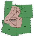
southwest of Monument Valley at the north end of the Hopi Reservation, this remote coal-laden highland has about half of the Colorado Plateau's acreage north...
35 KB (4,138 words) - 10:38, 8 June 2025

can be tracked from the ground visually using theodolites. Remote sensing techniques for wind include SODAR, Doppler lidars and radars, which can measure...
107 KB (11,323 words) - 21:10, 27 June 2025

Urban heat island (section On energy usage for cooling)
surface temperatures within the UHI can be easily seen via thermal remote sensing. As is often the case with daytime heating, this warming also has the...
85 KB (9,659 words) - 19:14, 22 June 2025

the application of remote sensors to study coastal environments. He co-edited with Richard Miller and Brent McKee, Remote Sensing of the Coastal Environment...
94 KB (11,282 words) - 00:18, 26 June 2025
fire history can be recorded on fire maps and atlases, often using remote sensing. The Canadian National Fire Database is a record of large fire events...
26 KB (3,186 words) - 21:22, 19 June 2025

and pathways through forests, and preventing fire. Many tools like remote sensing, GIS and photogrammetry modelling have been developed to improve forest...
112 KB (22,464 words) - 14:33, 23 May 2025
call signs (telephony designator). Historical assignments are also included for completeness. All 0–9 A B C D E F G H I J K L M N O P Q R S T U V W X Y Z...
3 KB (782 words) - 21:23, 6 June 2025

Coral reef (redirect from Tropical coral reef)
and coral reef ecosystems: Clues from coral proxies and remote sensing records" (PDF). Centre for Marine Studies. Synthesis of research from an ARC Linkage...
169 KB (18,828 words) - 13:57, 19 June 2025
concentrated in the Sierra Madre del Sur, the Yucatán Peninsula, and the most remote and difficult-to-access areas, such as the Sierra Madre Oriental, the Sierra...
250 KB (24,812 words) - 08:51, 25 June 2025

observations, for example from storm spotters; and on remote sensing, especially weather radar. Some in situ measurements are used for direct detection...
36 KB (4,280 words) - 06:13, 25 January 2025

maui wildfires, implications and needs for satellite-based wildfire disaster monitoring". Science of Remote Sensing. 10: 100142. Bibcode:2024SciRS..1000142R...
61 KB (6,313 words) - 06:31, 28 June 2025

predicted that all coral reefs will be in danger. In the Caribbean Sea and tropical Pacific Ocean, direct contact between coral and common seaweeds causes...
95 KB (10,766 words) - 20:50, 14 June 2025
PMID 15590771. Grimm, David (26 May 2017). "Earliest evidence for dog breeding found on remote Siberian island". Science. Retrieved 28 May 2020. Possehl,...
255 KB (25,842 words) - 10:47, 25 June 2025

the continental ice sheet, is being revealed by techniques such as remote sensing, ground-penetrating radar, and satellite imagery. Geologically, West...
149 KB (16,060 words) - 05:02, 28 June 2025

Waterway Research. INPOH National Institute for Space Research in São Paulo conducts ocean remote sensing research. INPE Brazilian universities with oceanography...
57 KB (5,090 words) - 10:26, 18 June 2025

H (2019). Raptor perch sites for biological control of agricultural pest rodents. In: Geo-trekking in Ethiopia's Tropical Mountains – The Dogu'a Tembien...
105 KB (10,725 words) - 07:35, 25 June 2025

located in southeastern New England.: 57–9 In 1809, the number of mills had grown to 62, with 25 under construction. To meet increased demand for cloth,...
329 KB (38,600 words) - 00:35, 19 June 2025

November 21, 2009. Preliminary data from NASA's Lunar Crater Observation and Sensing Satellite, or LCROSS, indicates the mission successfully uncovered water...
431 KB (44,381 words) - 05:52, 28 June 2025

of Madagascar and numerous smaller peripheral islands. Lying off the southeastern coast of Africa, it is the world's fourth largest island, the second-largest...
247 KB (24,093 words) - 12:20, 22 June 2025

policies have made the prospect of official recognition of many ethnicities a remote possibility. Current trends in ethno-tourism have led many former Plains...
200 KB (23,960 words) - 13:13, 28 June 2025

Islands, Remote Oceania, Polynesia, and Wallacea. In Indonesia, the nationalistic term Nusantara, from Old Javanese, is also popularly used for the Indonesian...
280 KB (25,877 words) - 13:51, 18 June 2025