
A nautical chart or hydrographic chart is a graphic representation of a sea region or water body and adjacent coasts or banks. Depending on the scale of...
18 KB (2,302 words) - 22:01, 20 May 2025
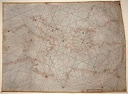
Portolan charts are nautical charts, first made in the 13th century in the Mediterranean basin and later expanded to include other regions. The word portolan...
19 KB (2,309 words) - 12:34, 28 May 2025

surround) for a specific purpose are often known as charts, such as a nautical chart or aeronautical chart, typically spread over several map sheets. Other...
13 KB (1,513 words) - 22:21, 24 May 2025

Compass rose (section Depiction on nautical charts)
monuments. It is particularly common in navigation systems, including nautical charts, non-directional beacons (NDB), VHF omnidirectional range (VOR) systems...
27 KB (2,818 words) - 04:58, 27 May 2025

A chart datum is the water surface serving as origin (or coordinate surface) of depths displayed on a nautical chart and for reporting and predicting tide...
10 KB (1,220 words) - 20:30, 20 April 2025
Knot (unit) (redirect from Knot (nautical))
system. As a result, nautical miles and knots are convenient units to use when navigating an aircraft or ship. On a standard nautical chart using Mercator projection...
10 KB (1,233 words) - 09:41, 22 May 2025

Cambridge History of Scandinavia. Cambridge University Press. p. 37. Nautical chart: International no. 1205, SE61, Baltic Sea, North, Sea of Åland. Jeppe...
11 KB (1,051 words) - 07:46, 2 May 2025

Navigator (section Nautical charts)
navigator is in charge of maintaining the aircraft or ship's nautical charts, nautical publications, and navigational equipment, and they generally have...
14 KB (1,834 words) - 20:49, 19 March 2025

Admiralty charts are nautical charts issued by the United Kingdom Hydrographic Office (UKHO) and subject to Crown Copyright. Over 3,500 Standard Nautical Charts...
27 KB (3,140 words) - 06:38, 31 May 2025

worldwide. Hydrographic/nautical chart – Topographic map of a maritime area and adjacent coastal regions General Bathymetric Chart of the Oceans – Publicly...
9 KB (1,929 words) - 01:05, 12 January 2025

the color pattern of the compass rose found on many nautical charts. Insignia including nautical stars: United States Coast Guard officer rank insignia...
8 KB (747 words) - 18:02, 6 March 2025
authority on hydrographic surveying and nautical charting. When referring to hydrography and nautical charting in conventions and similar instruments,...
16 KB (1,767 words) - 01:01, 29 May 2025

Depth sounding (redirect from Lead line (nautical))
such as the seabed topography. Soundings were traditionally shown on nautical charts in fathoms and feet. The National Oceanic and Atmospheric Administration...
13 KB (1,721 words) - 21:54, 19 April 2025

alternative to paper nautical charts for navigation by ships. IMO refers to similar systems not meeting the regulations as Electronic Chart Systems (ECSs)....
15 KB (1,604 words) - 04:17, 5 May 2025

map, nautical chart, engineering drawing, or architectural drawing. A scale bar is common element of map layouts. On large scale maps and charts, those...
6 KB (605 words) - 06:42, 18 May 2024

A vigia is a warning on a nautical chart indicating a possible rock, shoal, or other hazard which has been reported but not yet verified or surveyed. Some...
5 KB (450 words) - 18:35, 27 May 2025
Mercator projection (redirect from Mercator chart)
cylindrical projection List of map projections Mercator 1569 world map Nautical chart Omission of New Zealand from maps – often believed to be caused by the...
49 KB (6,858 words) - 07:09, 29 May 2025
Look up charting in Wiktionary, the free dictionary. Charting may refer to: Chart, graphical representation of data Nautical chart, process of building...
271 bytes (67 words) - 15:19, 20 May 2023
mariner's handbook of written sailing directions. Before the advent of nautical charts, rutters were the primary store of geographic information for maritime...
14 KB (1,665 words) - 16:41, 1 March 2025

Cornaro Atlas (section Nautical charts)
Atlas (Egerton MS 73) is an extensive Venetian collection (c. 1489) of nautical charts and tracts, currently held in the Egerton Collection of manuscripts...
11 KB (1,519 words) - 14:51, 10 May 2025
This glossary of nautical terms is an alphabetical listing of terms and expressions connected with ships, shipping, seamanship and navigation on water...
315 KB (39,194 words) - 00:28, 3 June 2025
An aeronautical chart is a map designed to assist in the navigation of aircraft, much as nautical charts do for watercraft, or a roadmap does for drivers...
4 KB (583 words) - 23:36, 13 January 2025
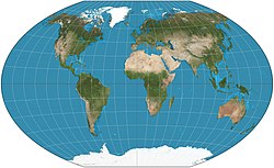
best-known projection is the Mercator Projection, originally designed as a nautical chart. Mercator projection (showing between 82°S and 82°N) Mollweide projection...
9 KB (905 words) - 02:27, 3 June 2025

rectangular island in the 1424 portolan chart of Zuane Pizzigano. Thereafter, it routinely appeared in most nautical charts of the 15th century. After 1492,...
40 KB (5,239 words) - 18:35, 2 February 2025
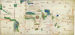
and the evolution of nautical cartography during the Age of Discovery. The Cantino planisphere is the earliest extant nautical chart that depicts places...
18 KB (2,415 words) - 14:31, 24 May 2025
(Majorcan cartographic school) Barcelona Angelino Dulcert Abraham Cresques Nautical chart Països Catalans Rhumbline network Història de la Marina Catalana La...
4 KB (433 words) - 06:52, 4 August 2024

Danish Nautical Charts Archive (Danish: Det Kongelige danske Søkortarkiv) was a Danish Navy department, responsible for making accurate nautical charts for...
3 KB (291 words) - 08:14, 23 October 2024
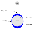
tide chart is not available, most nautical charts have "tidal diamonds" which relate specific points on the chart to a table giving tidal flow direction...
109 KB (13,077 words) - 15:20, 26 May 2025
OpenSeaMap (category Nautical charts)
project collecting freely usable nautical information and geospatial data to create a worldwide nautical chart. This chart is available on the OpenSeaMap...
10 KB (1,134 words) - 20:29, 15 March 2025