Area navigation (RNAV, usually pronounced as /ˈɑːrnæv/) is a method of instrument flight rules (IFR) navigation that allows aircraft to fly along a desired...
11 KB (1,326 words) - 09:50, 14 February 2025
ICAO performance-based navigation (PBN) specifies that aircraft required navigation performance (RNP) and area navigation (RNAV) systems performance requirements...
18 KB (2,433 words) - 04:44, 6 March 2024
aviation, lateral navigation (LNAV, usually pronounced el-nav) is azimuth navigation, without vertical navigation (VNAV). Area navigation (RNAV) approach...
2 KB (188 words) - 04:33, 6 March 2024
Indian Regional Navigation Satellite System (IRNSS), with an operational name of NavIC (acronym for Navigation with Indian Constellation; also, nāvik 'sailor'...
64 KB (5,319 words) - 14:04, 21 May 2025
A satellite navigation or satnav system is a system that uses satellites to provide autonomous geopositioning. A satellite navigation system with global...
45 KB (4,560 words) - 11:19, 28 May 2025
The field of navigation includes four general categories: land navigation, marine navigation, aeronautic navigation, and space navigation. It is also the...
83 KB (9,370 words) - 14:32, 23 May 2025
Sonne (German for "sun") was a radio navigation system developed in Germany during World War II. It was developed from an earlier experimental system known...
22 KB (3,148 words) - 03:58, 28 May 2025
The Wide Area Augmentation System (WAAS) is an air navigation aid developed by the Federal Aviation Administration to augment the Global Positioning System...
42 KB (4,012 words) - 16:26, 17 March 2025
aircraft to fly a specific path between two 3D-defined points in space. Area navigation (RNAV) and RNP systems are fundamentally similar. The key difference...
27 KB (3,644 words) - 03:29, 24 February 2025
VHF omnidirectional range (category Aeronautical navigation systems)
means navigation system for commercial and general aviation, (D)VOR are gradually decommissioned and replaced by DME-DME RNAV (area navigation) 7.2.3...
53 KB (6,919 words) - 09:32, 11 March 2025
the reference beacon(s). Rho-Theta methodology is a key component in Area Navigation (RNAV). The term "Rho-Theta" consists of the two Greek letters corresponding...
2 KB (164 words) - 22:45, 24 May 2025
Ice navigation is a specialist area of navigation involving the use of maritime skills to determine and monitor the position of ships in cold waters,...
6 KB (733 words) - 12:07, 6 December 2023
application to arriving IFR aircraft destined for certain airports. Area navigation (RNAV) STAR/FMSP procedures for arrivals serve the same purpose but...
5 KB (683 words) - 05:41, 19 January 2025
video game AI in 2000. A navigation mesh is a collection of two-dimensional convex polygons (a polygon mesh) that define which areas of an environment are...
6 KB (658 words) - 03:28, 17 February 2025
Web navigation refers to the process of navigating a network of information resources in the World Wide Web, which is organized as hypertext or hypermedia...
11 KB (1,140 words) - 17:22, 22 May 2025
Radio navigation or radionavigation is the application of radio waves to determine a position of an object on the Earth, either the vessel or an obstruction...
40 KB (5,315 words) - 22:23, 16 January 2025
Battle of the Beams (redirect from Knickebein (navigation))
Force (Luftwaffe) used a number of increasingly accurate systems of radio navigation for night bombing in the United Kingdom. British scientific intelligence...
30 KB (4,306 words) - 22:20, 19 April 2025
The basic principles of air navigation are identical to general navigation, which includes the process of planning, recording, and controlling the movement...
21 KB (3,087 words) - 22:23, 29 March 2025
Distance measuring equipment (category Radio navigation)
In aviation, distance measuring equipment (DME) is a radio navigation technology that measures the slant range (distance) between an aircraft and a ground...
18 KB (2,366 words) - 04:55, 29 March 2025
the continental shelf. Their jurisdiction covers, depending on the area: navigation, fishing, mineral extraction from the seabed, customs, fiscal, research...
3 KB (421 words) - 16:45, 27 August 2024
Inuit navigation techniques are those navigation skills used for thousands of years by the Inuit, a group of culturally similar indigenous peoples who...
12 KB (1,294 words) - 00:43, 25 May 2025
Submarine navigation underwater requires special skills and technologies not needed by surface ships. The challenges of underwater navigation have become...
10 KB (967 words) - 13:41, 14 December 2024
Lowest safe altitude (redirect from Area minimum altitude)
the flight path depends on the method of navigation (radio navigation aid, dead reckoning or area navigation systems) and on the flight rules (instrument...
6 KB (900 words) - 09:51, 15 April 2025
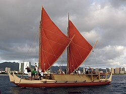
Polynesian navigation or Polynesian wayfinding was used for thousands of years to enable long voyages across thousands of kilometres of the open Pacific...
59 KB (6,995 words) - 19:59, 23 May 2025
term used in satellite navigation and geomatics engineering to specify the error propagation as a mathematical effect of navigation satellite geometry on...
16 KB (2,224 words) - 18:22, 1 July 2024
Eurocontrol (redirect from European organisation for the safety of air navigation)
The European Organisation for the Safety of Air Navigation, commonly known as Eurocontrol (stylised EUROCONTROL), is an international organisation working...
19 KB (1,522 words) - 11:50, 10 February 2025
Navigational instruments are instruments used by nautical navigators and pilots as tools of their trade. The purpose of navigation is to ascertain the...
6 KB (779 words) - 15:27, 8 October 2024
An automotive navigation system is part of the automobile controls or a third party add-on used to find direction in an automobile. It typically uses a...
21 KB (2,335 words) - 22:46, 5 May 2025
Marine navigation is the art and science of steering a ship from a starting point (sailing) to a destination, efficiently and responsibly. It is an art...
30 KB (2,842 words) - 09:03, 25 May 2025
Geodesics on an ellipsoid (redirect from Geodesic polygon area)
for Area Navigation (PDF) (Technical report). Washington, D.C.: U.S. Federal Aviation Administration. Sjöberg, L. E. (2006). "Determination of areas on...
73 KB (8,506 words) - 15:35, 22 April 2025


