the OpenSeaMap website, and can also be downloaded for use as an electronic chart for offline applications. The project is part of OpenStreetMap. OpenSeaMap...
10 KB (1,134 words) - 20:29, 15 March 2025
railway infrastructure based on OSM data. OpenSeaMap is a world nautical chart built as a mashup of OpenStreetMap, crowdsourced water depth tracks, and third-party...
111 KB (10,744 words) - 06:46, 7 August 2025

Nautical chart (redirect from Sea map)
In modern times, echo sounding is used for measuring the seabed in the open sea. When measuring the safe depth of water over an entire obstruction, such...
18 KB (2,301 words) - 00:26, 14 June 2025

www.baken-net.de. Retrieved 21 February 2019. "OpenSeaMap - The free nautical chart". map.openseamap.org. Retrieved 21 February 2019. "UFS TW/EMS". www...
33 KB (3,796 words) - 17:42, 2 August 2025

used by Reginald Fessenden to develop sonars. In the free nautical chart OpenSeaMap, 175 seamarks with bells as fog signals have been entered by volunteers...
13 KB (1,520 words) - 13:48, 20 June 2025

2022-09-13. "Norwegian ENC Data in OpenCPN". 2017-09-11. Wikimedia Commons has media related to OpenCPN. Free and open-source software portal OpenSeaMap v t e...
3 KB (167 words) - 17:25, 4 October 2024
between 1250m and 1500m along the edge of a basin. "OpenSeaMap - Sinking location". map.openseamap.org. Retrieved 2020-06-09. "Deperm (ADG 10) / ex-YDG-10...
3 KB (161 words) - 22:18, 23 June 2025

Sens. 12, 52 Bärlocher, Markus (March 2013). "OpenSeaMap – the Free Nautical Chart" (PDF). openseamap.org. Hydro International. pp. 28–33. "NOAA Hydrographic...
34 KB (4,103 words) - 09:33, 14 May 2025

on the Internet Archive "OpenSeaMap: Frequently Asked Questions". OpenSeaMap.org. Retrieved April 28, 2012. "OpenStreetMap: Copyright and License". Openstreetmap...
47 KB (1,926 words) - 08:33, 7 August 2025
historical map of the world using OpenStreetMap technology and processes. OpenSeaMap is a free nautical chart covering seas, lakes, inland waterways and rivers...
82 KB (9,070 words) - 21:30, 16 June 2025
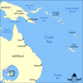
Map all coordinates using OpenStreetMap Download coordinates as: KML GPX (all coordinates) GPX (primary coordinates) GPX (secondary coordinates) The Coral...
59 KB (5,941 words) - 15:38, 23 June 2025
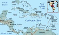
List of Caribbean islands (redirect from List of islands in the Caribbean Sea)
Map all coordinates using OpenStreetMap Download coordinates as: KML GPX (all coordinates) GPX (primary coordinates) GPX (secondary coordinates) Most...
105 KB (18,788 words) - 09:09, 31 July 2025

Village | North Cyprus". www.northcyprus.co.uk. Retrieved 2016-04-08. "OpenSeaMap". "A History of Cyprus". kypros.org. Retrieved 2016-04-08. Northern Cyprus...
6 KB (337 words) - 11:50, 22 November 2024
Philippine Sea' on the map". South China Morning Post. Retrieved April 22, 2025. Kang, Taejun (April 17, 2025). "Beijing, Manila at odds over Google Maps update...
164 KB (14,286 words) - 00:43, 17 July 2025

A sea is a large body of salt water. There are particular seas and the sea. The sea commonly refers to the ocean, the interconnected body of seawaters...
179 KB (19,098 words) - 23:22, 1 August 2025

Map all coordinates using OpenStreetMap Download coordinates as: KML GPX (all coordinates) GPX (primary coordinates) GPX (secondary coordinates) This...
60 KB (11,329 words) - 16:19, 4 August 2025
Map all coordinates in "Geography of the North Sea" using OpenStreetMap Download coordinates as: KML GPX (all coordinates) GPX (primary coordinates) GPX...
137 KB (12,141 words) - 06:12, 3 July 2025
The Open Polar Sea was a conjectured ice-free body of water that was believed to encircle the North Pole. Although this theory was widely accepted and...
6 KB (749 words) - 19:14, 3 February 2025

said to exist to the west that was washed away in the sixteenth century. OpenSeaMap show the island name as Fraoch-eilean with Seana Bhaile being identified...
6 KB (833 words) - 09:22, 4 August 2025
one of the first maps of the world, which was circular in form and showed the known lands of the world grouped around the Aegean Sea at the center. This...
74 KB (8,610 words) - 04:58, 21 July 2025

List of islands of Turkey (section Aegean Sea islands)
coordinates. The following islands are in the Aegean Sea: Map this section's coordinates using OpenStreetMap Download coordinates as: KML GPX (all coordinates)...
36 KB (591 words) - 09:31, 5 December 2024
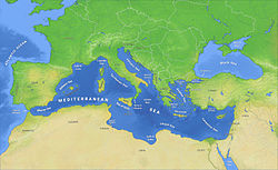
The Mediterranean Sea (/ˌmɛdɪtəˈreɪniən/ MED-ih-tə-RAY-nee-ən) is a sea connected to the Atlantic Ocean, surrounded by the Mediterranean basin and almost...
166 KB (15,210 words) - 02:50, 3 August 2025
Map all coordinates using OpenStreetMap Download coordinates as: KML GPX (all coordinates) GPX (primary coordinates) GPX (secondary coordinates) This...
1 KB (188 words) - 23:01, 30 January 2025
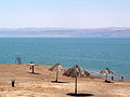
rift valley (from the Sea of Galilee to the present-day Dead Sea....) in the Late Neogene. After its disconnection from the open sea that could be associated...
89 KB (9,618 words) - 17:16, 18 July 2025

atmosphere less than a MAP sensor reads. At sea level one can convert boost to MAP by adding approximately 100 kPa. One can convert from MAP to boost by subtracting...
7 KB (979 words) - 07:13, 18 July 2025

Map all coordinates using OpenStreetMap Download coordinates as: KML GPX (all coordinates) GPX (primary coordinates) GPX (secondary coordinates) This...
45 KB (2,422 words) - 03:34, 1 August 2025
The heights are given in metres above the Adriatic Sea. Map all coordinates using OpenStreetMap Download coordinates as: KML GPX (all coordinates) GPX...
93 KB (777 words) - 01:12, 12 February 2025

the sea in the first half of the 19th century. The Second Kamchatka Expedition under Vitus Bering systematically mapped the entire coast of the sea, starting...
20 KB (2,167 words) - 05:43, 28 July 2025

a map projection is any of a broad set of transformations employed to represent the curved two-dimensional surface of a globe on a plane. In a map projection...
59 KB (6,472 words) - 04:30, 30 July 2025

Map all coordinates using OpenStreetMap Download coordinates as: KML GPX (all coordinates) GPX (primary coordinates) GPX (secondary coordinates) The tallest...
254 KB (944 words) - 23:09, 6 August 2025