OpenStreetMap (abbreviated OSM) is a free, open map database updated and maintained by a community of volunteers via open collaboration. Contributors...
111 KB (10,651 words) - 17:25, 14 June 2025
first State of the Map conference in Manchester. In October 2009, the foundation announced that its members, rather than the OpenStreetMap contributors at...
13 KB (1,173 words) - 05:11, 24 June 2025
historical data with an open access model. However, it has a peer review process, which is distinct from the OpenHistoricalMap and OpenStreetMap projects' focus...
21 KB (1,984 words) - 18:47, 16 July 2025

Organic Maps is a free and open-source, offline navigation app that uses map data from OpenStreetMap. The application is designed to function without internet...
8 KB (737 words) - 14:32, 14 June 2025

for OpenRailwayMap - Apps on Google Play". play.google.com. Retrieved 2024-09-08. "OpenRailwayMap/API - OpenStreetMap Wiki". wiki.openstreetmap.org....
6 KB (487 words) - 20:53, 7 April 2025
the OpenSeaMap website, and can also be downloaded for use as an electronic chart for offline applications. The project is part of OpenStreetMap. OpenSeaMap...
10 KB (1,134 words) - 20:29, 15 March 2025
Maps APIs. Since 2020, the map data is provided by TomTom, OpenStreetMap and others. Bing Maps was originally launched as MSN Virtual Earth, which was released...
46 KB (3,319 words) - 19:43, 21 June 2025
"MapQuest Open – Beta". Open MapQuest.co.uk. Retrieved 2011-12-20. "MapQuest - OpenStreetMap Wiki". Chuang, Tamara (19 October 2015). "MapQuest gets a new look...
14 KB (1,362 words) - 01:01, 24 February 2025
Map all coordinates using OpenStreetMap Download coordinates as: KML GPX (all coordinates) GPX (primary coordinates) GPX (secondary coordinates) Most...
105 KB (18,788 words) - 19:58, 27 July 2025
freely on GitHub. OpenDroneMap has been integrated within American Red Cross's in-field Portable OpenStreetMap system. OpenDroneMap can be controlled...
5 KB (466 words) - 09:33, 4 June 2025

CoMaps is a community-driven, free and open-source, offline navigation app that uses map data from OpenStreetMap (OSM). The app is designed to function...
9 KB (719 words) - 10:18, 27 July 2025
list of alpine ski resorts in the U.S. State of Colorado. Map all coordinates using OpenStreetMap Download coordinates as: KML GPX (all coordinates) GPX...
4 KB (400 words) - 16:14, 13 May 2025

cartography, a trap street is a fictitious entry in the form of a misrepresented street on a map, often outside the area the map nominally covers, for...
7 KB (821 words) - 22:45, 9 September 2024
Maps.me is a mobile app for Android, iOS and BlackBerry that provides offline maps using OpenStreetMap data. It was formerly known as MapsWithMe. In November...
9 KB (715 words) - 21:59, 28 May 2025

tiled maps include Google Maps API, OpenLayers and Leaflet. "OpenStreetMap wiki". "Slippy map tilenames - OpenStreetMap Wiki". wiki.openstreetmap.org....
5 KB (678 words) - 04:55, 19 March 2025


StreetComplete is an easy to use OpenStreetMap editor that can be used without prior knowledge about OpenStreetMap. The app prompts users to answer questions...
6 KB (443 words) - 07:04, 10 June 2025

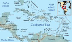
The World (archipelago) (category World maps)
France on OpenStreetMap 25°13′24″N 55°09′34″E / 25.22334°N 55.15937°E / 25.22334; 55.15937 (France) 2713321 (x j a h) California on OpenStreetMap 25°12′11″N...
31 KB (3,115 words) - 04:58, 25 July 2025
Comparison of satellite navigation software Comparison of web map services OpenStreetMap Here Map Creator Wikimapia "Installation and setup. Set up the app...
10 KB (890 words) - 15:43, 9 May 2025
Web Mercator projection (category Google Maps)
used by virtually all major online map providers, including Google Maps, CARTO, Mapbox, Bing Maps, OpenStreetMap, Mapquest, Esri, and many others. Its...
16 KB (1,712 words) - 13:28, 25 May 2025

Map all coordinates using OpenStreetMap Download coordinates as: KML GPX (all coordinates) GPX (primary coordinates) GPX (secondary coordinates) This...
45 KB (2,418 words) - 16:32, 29 July 2025

Map all coordinates using OpenStreetMap Download coordinates as: KML GPX (all coordinates) GPX (primary coordinates) GPX (secondary coordinates) Bermuda...
31 KB (93 words) - 02:26, 21 March 2025
all having coordinates below may be seen on a map by clicking "Map all coordinates using OpenStreetMap" at the right side of this page. Pegla (Zadar,...
70 KB (1,916 words) - 12:34, 12 July 2025

Mapy.com (category OpenStreetMap)
Retrieved 7 December 2024. "OpenStreetMap Wiki: Mapy.cz". wiki.openstreetmap.org. Retrieved 2024-12-06. "Corporate Members". OpenStreetMap Foundation. Retrieved...
7 KB (569 words) - 12:17, 26 June 2025

Map all coordinates in "Category:Kochi Metro stations" using OpenStreetMap Download coordinates as: KML GPX (all coordinates) GPX (primary coordinates)...
17 KB (597 words) - 02:41, 1 June 2025
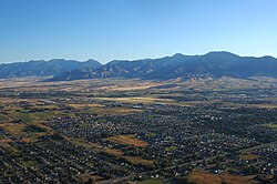
Map all coordinates using OpenStreetMap Download coordinates as: KML GPX (all coordinates) GPX (primary coordinates) GPX (secondary coordinates) Bozeman...
78 KB (7,165 words) - 11:06, 9 July 2025

North–South MRT line (category Railway lines opened in 1987)
December 2015. OpenStreetMap contributors (28 March 2020). "Woodlands MRT station" (Map). OpenStreetMap. Retrieved 28 March 2020. {{cite map}}: |author=...
97 KB (7,154 words) - 02:22, 29 July 2025
2016. Baidu uses map data supplied by NavInfo, MapKing, Here, LocalKing and OpenStreetMap. In 2016, it was reported that Baidu Maps had over 348 million...
15 KB (1,068 words) - 05:06, 10 May 2025

Map all coordinates using OpenStreetMap Download coordinates as: KML GPX (all coordinates) GPX (primary coordinates) GPX (secondary coordinates) The 180th...
7 KB (416 words) - 17:01, 10 July 2025
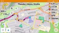
OsmAnd (category OpenStreetMap)
(/ˈoʊsəmænd/; OpenStreetMap Automated Navigation Directions) is a free and open-source map and navigation app for Android and iOS. It uses the OpenStreetMap (OSM)...
12 KB (1,298 words) - 12:46, 6 July 2025