
The Satellite Data System (SDS) is a system of United States military communications satellites. At least three generations have been used: SDS-1 from...
12 KB (527 words) - 14:10, 4 June 2025
and Data Relay Satellite System (TDRSS, pronounced "T-driss") is a network of American communications satellites (each called a tracking and data relay...
19 KB (2,575 words) - 07:32, 5 April 2025

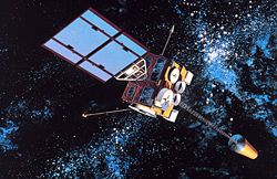
tracking and data relay satellite (TDRS) is a type of communications satellite that forms part of the Tracking and Data Relay Satellite System (TDRSS) used...
14 KB (1,402 words) - 02:42, 10 June 2025

is a classified artificial intelligence (AI)–powered satellite-based intelligence analysis system developed and operated by the National Reconnaissance...
28 KB (2,041 words) - 16:59, 31 July 2025

and others in the Argos system) or in dedicated satellites (such as SCD). The data rate is typically much lower than in satellite Internet access. Commercialization...
50 KB (5,998 words) - 19:38, 22 July 2025

navigation satellite system (GNSS) provides coverage for any user on Earth, including air, land, and sea. There are four operational GNSS systems: the United...
45 KB (4,562 words) - 19:13, 4 August 2025
The Global Positioning System (GPS) is a satellite-based hyperbolic navigation system owned by the United States Space Force and operated by Mission Delta...
185 KB (19,205 words) - 16:49, 1 August 2025
Indian Data Relay Satellite System or IDRSS is a planned Indian constellation of Inter-satellite communications satellites. It is planned to initially...
8 KB (625 words) - 07:47, 31 December 2024

Argos is a global satellite-based system that collects, processes, and disseminates (spreads, distributes) environmental data from fixed and mobile platforms...
11 KB (1,126 words) - 09:05, 4 June 2025

Quasi-Zenith Satellite System (QZSS) (Japanese: 準天頂衛星システム, Hepburn: juntenchō eisei shisutemu), also known as Michibiki (みちびき, "guidance"), is a four-satellite regional...
22 KB (1,892 words) - 05:25, 27 July 2025
Iridium Communications (redirect from Iridium satellite)
constellation, a system of 80 satellites: 66 are active satellites and the remaining fourteen function as in-orbit spares. Iridium Satellites are used for...
43 KB (3,960 words) - 10:50, 27 May 2025

Indian Regional Navigation Satellite System (IRNSS), with an operational name of NavIC (acronym for Navigation with Indian Constellation; also, nāvik 'sailor'...
64 KB (5,319 words) - 00:02, 5 July 2025
BeiDou (redirect from Beidou satellite navigation system)
Navigation Satellite System (BDS; Chinese: 北斗卫星导航系统; pinyin: běidǒu wèixīng dǎoháng xìtǒng) is a satellite-based radio navigation system owned and operated...
69 KB (5,974 words) - 17:24, 27 July 2025

The Transit system, also known as NAVSAT or NNSS (for Navy Navigation Satellite System), was the first satellite navigation system to be used operationally...
32 KB (3,712 words) - 08:02, 31 May 2025
The Joint Polar Satellite System (JPSS) is the latest generation of U.S. polar-orbiting, non-geosynchronous, environmental satellites. JPSS will provide...
22 KB (2,481 words) - 13:22, 1 July 2025
Galileo is a global navigation satellite system (GNSS) created by the European Union through the European Space Agency (ESA) and operated by the European...
103 KB (10,187 words) - 17:33, 2 August 2025
Environmental Satellite (GOES), operated by the United States' National Oceanic and Atmospheric Administration (NOAA)'s National Environmental Satellite, Data, and...
40 KB (4,222 words) - 15:35, 10 June 2025
A satellite data unit (SDU) is an avionics device installed in an aircraft that allows air/ground communication via a satellite network. It is an integral...
3 KB (369 words) - 02:22, 27 August 2024

and systems that use satellites in low Earth orbit (LEO), 640 to 1,120 kilometers (400 to 700 miles) above the Earth. The connection and regular data order...
46 KB (4,889 words) - 23:04, 10 July 2025
The World Geodetic System (WGS) is a standard used in cartography, geodesy, and satellite navigation including GPS. The current version, WGS 84, defines...
25 KB (2,857 words) - 01:38, 17 July 2025

KH-11 KENNEN (redirect from KH-11 spy satellite)
Hazzard. The KENNEN system transmits its imagery as data through the Satellite Data System (SDS), a network of communications satellites. These digital images...
53 KB (5,166 words) - 23:24, 22 July 2025
The National Environmental Satellite, Data, and Information Service (NESDIS) was created by the National Oceanic and Atmospheric Administration (NOAA)...
8 KB (699 words) - 01:45, 16 January 2025

Satellite images (also Earth observation imagery, spaceborne photography, or simply satellite photo) are images of Earth collected by imaging satellites...
32 KB (3,731 words) - 12:52, 27 July 2025
The European Data Relay System (EDRS) system is a European constellation of GEO satellites that relay information and data between satellites, spacecraft...
12 KB (1,152 words) - 12:33, 30 May 2025
The Indian National Satellite System or INSAT, is a series of multipurpose geostationary satellites launched by the Indian Space Research Organisation...
37 KB (2,953 words) - 12:15, 26 October 2024
GLONASS (redirect from GLObal NAvigation Satellite System)
'Global Navigation Satellite System') is a Russian satellite navigation system operating as part of a radionavigation-satellite service. It provides...
72 KB (6,263 words) - 21:05, 25 July 2025

of the US Tracking and Data Relay Satellite System. The first generation of satellites was created by NPO-PM using the satellite platform KAUR-4 (its first...
15 KB (1,179 words) - 20:33, 24 October 2024

identification system (AIS) is an automatic tracking system that uses transceivers on ships and is used by vessel traffic services (VTS). When satellites are used...
90 KB (11,207 words) - 15:47, 26 June 2025

Moons of Jupiter (redirect from Satellite of Jupiter)
captured by telescopes. All together, Jupiter's moons form a satellite system called the Jovian system. The most massive of the moons are the four Galilean moons:...
122 KB (6,833 words) - 04:25, 17 July 2025

grade satellite Internet service is typically provided to individual users through geostationary satellites that can offer relatively high data speeds...
70 KB (8,440 words) - 08:28, 28 June 2025